![](/images/other/stat-length.png)
![Trail Walking Saint-Arcons-de-Barges - Boucle de la forêt d'Arlempdes - Saint Arcon de Barges - Photo](https://media.geolcdn.com/t/1900/400/ext.pjpeg?maxdim=2&url=https%3A%2F%2Fservices.sitytrail.com%2FGeolivesWS%2FDownloadMedia.ashx%3FTrailID%3D107372%26Media%3D12272_2.jpg)
Boucle de la forêt d'Arlempdes - Saint Arcon de Barges
tracegps
User
![Length](/images/other/stat-length.png)
Length
13.5 km
![Max alt](https://static1.geolcdn.com/siteimages/upload/files/1508320355ic_sort_altitude_max_24dp.png)
Max alt
1068 m
![Uphill gradient](https://static1.geolcdn.com/siteimages/upload/files/1508320355ic_sort_den_pos_24dp.png)
Uphill gradient
491 m
![Km-Effort](/images/other/stat-length.png)
Km-Effort
20 km
![Min alt](https://static1.geolcdn.com/siteimages/upload/files/1508320355ic_sort_altitude_min_24dp.png)
Min alt
802 m
![Downhill gradient](https://static1.geolcdn.com/siteimages/upload/files/1508320355ic_sort_den_neg_24dp.png)
Downhill gradient
486 m
![Boucle](https://static1.geolcdn.com/siteimages/upload/files/16400158638029165_repeat_loop_refresh_sync_direction_icon.png)
Boucle
No
Creation date :
2014-12-10 00:00:00.0
Updated on :
2014-12-10 00:00:00.0
![Walking](https://static1.geolcdn.com/sitytour/trail-icons/101.png)
5h00
Difficulty : Medium
![Scan this QR Code to open this trail in the SityTrail application](https://capi.geolives.com/qq0zvz2zws4bq2lad0pu/sitytour/trails/107372/qr.png?size=200)
FREE GPS app for hiking
About
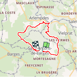
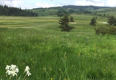
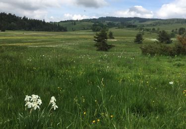
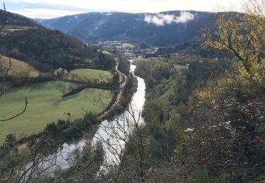
Trail Walking of 13.5 km to be discovered at Auvergne-Rhône-Alpes, Haute-Loire, Saint-Arcons-de-Barges. This trail is proposed by tracegps.
Description
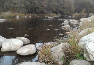
Beau circuit bien balisé en jaune. Ne pas rater le franchissement du cours d'eau avec les traverses en fer... peu orthodoxe mais pratique.
Positioning
Country:
France
Region :
Auvergne-Rhône-Alpes
Department/Province :
Haute-Loire
Municipality :
Saint-Arcons-de-Barges
Location:
Unknown
Start:(Dec)
Start:(UTM)
573217 ; 4965411 (31T) N.
Comments
Trails nearby
![Trail Walking Salettes - Camp D’Anthoune, Salettes (Haute-Loire) - Photo](https://media.geolcdn.com/t/375/260/cc87e0ec-268a-4d12-8da8-5e2775afe0e1.jpg&format=jpg&maxdim=2)
![Walking Walking](https://static1.geolcdn.com/sitytour/trail-icons/101.png)
Camp D’Anthoune, Salettes (Haute-Loire)
Walking
Salettes,
Auvergne-Rhône-Alpes,
Haute-Loire,
France
![](/images/other/stat-length.png)
4.2 km | 5.1 km-effort
1h 31min
![](https://static1.geolcdn.com/siteimages/upload/files/16400158638029165_repeat_loop_refresh_sync_direction_icon.png)
No
![Trail Walking Saint-Arcons-de-Barges - Mont Tartas - Photo](https://media.geolcdn.com/t/375/260/d3449528-8074-43c8-ab62-947ff7456094.jpg&format=jpg&maxdim=2)
![Walking Walking](https://static1.geolcdn.com/sitytour/trail-icons/101.png)
Mont Tartas
Walking
Easy
Saint-Arcons-de-Barges,
Auvergne-Rhône-Alpes,
Haute-Loire,
France
![](/images/other/stat-length.png)
4.6 km | 6.3 km-effort
55min
![](https://static1.geolcdn.com/siteimages/upload/files/16400158638029165_repeat_loop_refresh_sync_direction_icon.png)
No
![Trail Walking Coucouron - La tour de Villeneuve - Photo](https://media.geolcdn.com/t/375/260/05c31301-19c6-480c-919d-4c3f58fe8aa7.jpg&format=jpg&maxdim=2)
![Walking Walking](https://static1.geolcdn.com/sitytour/trail-icons/101.png)
La tour de Villeneuve
Walking
Medium
Coucouron,
Auvergne-Rhône-Alpes,
Ardèche,
France
![](/images/other/stat-length.png)
12.6 km | 16.4 km-effort
3h 6min
![](https://static1.geolcdn.com/siteimages/upload/files/16400158638029165_repeat_loop_refresh_sync_direction_icon.png)
Yes
![Trail Walking Arlempdes - Le Château d'Arlempdes et l'ancien Vivarais - Photo](https://media.geolcdn.com/t/375/260/ext.jpg?maxdim=2&url=https%3A%2F%2Fservices.sitytrail.com%2FGeolivesWS%2FDownloadMedia.ashx%3FTrailID%3D653301%26Media%3Dfix__20161030172715.jpg)
![Walking Walking](https://static1.geolcdn.com/sitytour/trail-icons/101.png)
Le Château d'Arlempdes et l'ancien Vivarais
Walking
Easy
(1)
Arlempdes,
Auvergne-Rhône-Alpes,
Haute-Loire,
France
![](/images/other/stat-length.png)
5.3 km | 7.4 km-effort
1h 39min
![](https://static1.geolcdn.com/siteimages/upload/files/16400158638029165_repeat_loop_refresh_sync_direction_icon.png)
Yes
![Walking Walking](https://static1.geolcdn.com/sitytour/trail-icons/101.png)
SityTrail - 2820318 - coucouron-x-moulin-courbet (1)
Walking
Easy
Coucouron,
Auvergne-Rhône-Alpes,
Ardèche,
France
![](/images/other/stat-length.png)
13.8 km | 17.7 km-effort
4h 1min
![](https://static1.geolcdn.com/siteimages/upload/files/16400158638029165_repeat_loop_refresh_sync_direction_icon.png)
Yes
![Trail Walking Coucouron - Coucouron - Moulin Courbet - Photo](https://media.geolcdn.com/t/375/260/79fd5b74-50ac-4cda-9410-542a3eb7c9bd.jpg&format=jpg&maxdim=2)
![Walking Walking](https://static1.geolcdn.com/sitytour/trail-icons/101.png)
Coucouron - Moulin Courbet
Walking
Difficult
(1)
Coucouron,
Auvergne-Rhône-Alpes,
Ardèche,
France
![](/images/other/stat-length.png)
13.8 km | 17.8 km-effort
4h 15min
![](https://static1.geolcdn.com/siteimages/upload/files/16400158638029165_repeat_loop_refresh_sync_direction_icon.png)
Yes
![Trail Walking Arlempdes - 2018-11-02 08:58:25 Jour - Photo](https://media.geolcdn.com/t/375/260/9b51640b-5e3d-4585-9ba4-1d73ef8d9e45.jpg&format=jpg&maxdim=2)
![Walking Walking](https://static1.geolcdn.com/sitytour/trail-icons/101.png)
2018-11-02 08:58:25 Jour
Walking
Very difficult
Arlempdes,
Auvergne-Rhône-Alpes,
Haute-Loire,
France
![](/images/other/stat-length.png)
31 km | 46 km-effort
9h 36min
![](https://static1.geolcdn.com/siteimages/upload/files/16400158638029165_repeat_loop_refresh_sync_direction_icon.png)
Yes
![Trail Walking Arlempdes - Masclaux Brugeyvoles - Photo](https://media.geolcdn.com/t/375/260/ext.jpg?maxdim=2&url=https%3A%2F%2Fservices.sitytrail.com%2FGeolivesWS%2FDownloadMedia.ashx%3FTrailID%3D419048%26Media%3Dfix__20150510173022.jpg)
![Walking Walking](https://static1.geolcdn.com/sitytour/trail-icons/101.png)
Masclaux Brugeyvoles
Walking
Very easy
Arlempdes,
Auvergne-Rhône-Alpes,
Haute-Loire,
France
![](/images/other/stat-length.png)
35 km | 47 km-effort
9h 55min
![](https://static1.geolcdn.com/siteimages/upload/files/16400158638029165_repeat_loop_refresh_sync_direction_icon.png)
No
![Trail 4x4 Lafarre - Rando haute Loire jour 2 - Photo](https://media.geolcdn.com/t/375/260/35379468-edfd-49e2-9922-298ad046e9ea.jpg&format=jpg&maxdim=2)
![4x4 4x4](https://static1.geolcdn.com/sitytour/trail-icons/403.png)
Rando haute Loire jour 2
4x4
Very difficult
Lafarre,
Auvergne-Rhône-Alpes,
Haute-Loire,
France
![](/images/other/stat-length.png)
48 km | 66 km-effort
3h 3min
![](https://static1.geolcdn.com/siteimages/upload/files/16400158638029165_repeat_loop_refresh_sync_direction_icon.png)
Yes