![](/images/other/stat-length.png)
![Trail Mountain bike Cunlhat - Route du Lait Cunlhat Domaize - Photo](https://media.geolcdn.com/t/1900/400/ext.pjpeg?maxdim=2&url=https%3A%2F%2Fstatic1.geolcdn.com%2Fsiteimages%2Fupload%2Ffiles%2F1524743154velo.jpg)
Route du Lait Cunlhat Domaize
tracegps
User
![Length](/images/other/stat-length.png)
![Max alt](https://static1.geolcdn.com/siteimages/upload/files/1508320355ic_sort_altitude_max_24dp.png)
![Uphill gradient](https://static1.geolcdn.com/siteimages/upload/files/1508320355ic_sort_den_pos_24dp.png)
![Km-Effort](/images/other/stat-length.png)
![Min alt](https://static1.geolcdn.com/siteimages/upload/files/1508320355ic_sort_altitude_min_24dp.png)
![Downhill gradient](https://static1.geolcdn.com/siteimages/upload/files/1508320355ic_sort_den_neg_24dp.png)
![Boucle](https://static1.geolcdn.com/siteimages/upload/files/16400158638029165_repeat_loop_refresh_sync_direction_icon.png)
![Mountain bike](https://static1.geolcdn.com/sitytour/trail-icons/202.png)
1h45
Difficulty : Difficult
![Scan this QR Code to open this trail in the SityTrail application](https://capi.geolives.com/qq0zvz2zws4bq2lad0pu/sitytour/trails/107340/qr.png?size=200)
FREE GPS app for hiking
About
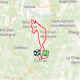
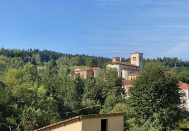
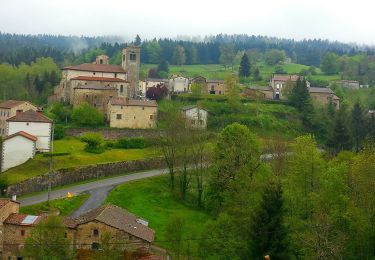
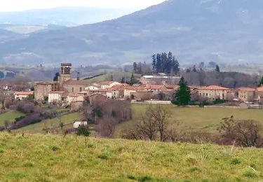
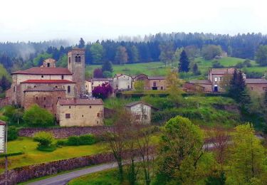
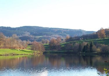
Trail Mountain bike of 22 km to be discovered at Auvergne-Rhône-Alpes, Puy-de-Dôme, Cunlhat. This trail is proposed by tracegps.
Description
Boucle VTT depuis Cunlhat (départ Place de l'Eglise) alternant chemins champêtres, chemins empierrés et petites routes. Le parcours va de hameaux en hameaux avec à l'arrivée un petit détour au château de Terrol. Parcours "difficile" en raison de quelques raides mais courts passages. L'ensemble reste très roulant et vous pourrez découvrir les mille et une fermes et hameaux (un vrai labyrinthe: merci le gps!) entre Cunlhat et Domaize.
Positioning
Comments
Trails nearby
![Trail Walking Auzelles - Auzelles_Sentier_Henriette - Photo](https://media.geolcdn.com/t/375/260/0998b436-04ee-4124-9f4e-bbd1323617bb.jpg&format=jpg&maxdim=2)
![Walking Walking](https://static1.geolcdn.com/sitytour/trail-icons/101.png)
Walking
![](/images/other/stat-length.png)
![](https://static1.geolcdn.com/siteimages/upload/files/16400158638029165_repeat_loop_refresh_sync_direction_icon.png)
![Trail On foot Ceilloux - Le Chemin du Bost - Photo](https://media.geolcdn.com/t/375/260/ba816805-0ba6-4be0-9595-fd3279994b1d.jpeg&format=jpg&maxdim=2)
![On foot On foot](https://static1.geolcdn.com/sitytour/trail-icons/100.png)
On foot
![](/images/other/stat-length.png)
![](https://static1.geolcdn.com/siteimages/upload/files/16400158638029165_repeat_loop_refresh_sync_direction_icon.png)
![Trail On foot Cunlhat - Le Chemin de Ronde - Photo](https://media.geolcdn.com/t/375/260/2fa8e53b-b8eb-4d5b-89fc-8615fa6c98ff.jpeg&format=jpg&maxdim=2)
![On foot On foot](https://static1.geolcdn.com/sitytour/trail-icons/100.png)
On foot
![](/images/other/stat-length.png)
![](https://static1.geolcdn.com/siteimages/upload/files/16400158638029165_repeat_loop_refresh_sync_direction_icon.png)
![Trail Walking Auzelles - La croix de Pradier, Auzelles - Photo](https://media.geolcdn.com/t/375/260/ff689157-2257-4cef-a67b-8243c47cd03e.jpeg&format=jpg&maxdim=2)
![Walking Walking](https://static1.geolcdn.com/sitytour/trail-icons/101.png)
Walking
![](/images/other/stat-length.png)
![](https://static1.geolcdn.com/siteimages/upload/files/16400158638029165_repeat_loop_refresh_sync_direction_icon.png)
![Trail On foot Cunlhat - La Pointe du Jour - Photo](https://media.geolcdn.com/t/375/260/2fa8e53b-b8eb-4d5b-89fc-8615fa6c98ff.jpeg&format=jpg&maxdim=2)
![On foot On foot](https://static1.geolcdn.com/sitytour/trail-icons/100.png)
On foot
![](/images/other/stat-length.png)
![](https://static1.geolcdn.com/siteimages/upload/files/16400158638029165_repeat_loop_refresh_sync_direction_icon.png)
![Trail On foot Auzelles - La Croix de Pradier - Photo](https://media.geolcdn.com/t/375/260/329d3c5e-d331-4c34-925f-d6dc7365d10e.jpeg&format=jpg&maxdim=2)
![On foot On foot](https://static1.geolcdn.com/sitytour/trail-icons/100.png)
On foot
![](/images/other/stat-length.png)
![](https://static1.geolcdn.com/siteimages/upload/files/16400158638029165_repeat_loop_refresh_sync_direction_icon.png)
![Trail Walking Tours-sur-Meymont - Tours_Meymont_Gorges_Dore - Photo](https://media.geolcdn.com/t/375/260/63fd52ef-9088-4caf-ab22-5e5d95806189.jpg&format=jpg&maxdim=2)
![Walking Walking](https://static1.geolcdn.com/sitytour/trail-icons/101.png)
Walking
![](/images/other/stat-length.png)
![](https://static1.geolcdn.com/siteimages/upload/files/16400158638029165_repeat_loop_refresh_sync_direction_icon.png)
![Trail Walking Auzelles - Auzelles_Croix_Pradier - Photo](https://media.geolcdn.com/t/375/260/e369bdcc-5010-4fb5-a830-f5591c707b99.jpg&format=jpg&maxdim=2)
![Walking Walking](https://static1.geolcdn.com/sitytour/trail-icons/101.png)
Walking
![](/images/other/stat-length.png)
![](https://static1.geolcdn.com/siteimages/upload/files/16400158638029165_repeat_loop_refresh_sync_direction_icon.png)
![Trail Walking Cunlhat - Cunlhat_Pointe_Jour - Photo](https://media.geolcdn.com/t/375/260/28565595-e7b6-4d92-8863-622673064867.jpg&format=jpg&maxdim=2)
![Walking Walking](https://static1.geolcdn.com/sitytour/trail-icons/101.png)
Walking
![](/images/other/stat-length.png)
![](https://static1.geolcdn.com/siteimages/upload/files/16400158638029165_repeat_loop_refresh_sync_direction_icon.png)