Trail Walking Le Mayet-de-Montagne - Balade entre Saint Clément et Le Mayet de Montagne - Photo

Balade entre Saint Clément et Le Mayet de Montagne

 tracegps
tracegps

User

© OpenStreetMap contributors
Length
Length
10.4 km
Max alt
Max alt
600 m
Uphill gradient
Uphill gradient
275 m
Km-Effort
Km-Effort  
14.1 km
Min alt
Min alt
454 m
Downhill gradient
Downhill gradient
273 m
Boucle
Boucle
Yes
Creation date :
2014-12-10 00:00:00.0
Updated on :
2014-12-10 00:00:00.0

(0 Reviews)

Walking
Walking
2h30
Difficulty : Medium

Scan this QR Code to open this trail in the SityTrail application

FREE GPS app for hiking

Logo SityTrail SityTrail

IGN / Geographical institutes

Download SityTrail from the App Store Download SityTrail from Google Play

Logo SityTrail SityTrail World

The world is yours!

Download SityTrail from the App Store Download SityTrail from Google Play Download SityTrail on Huawei AppGallery

About

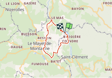
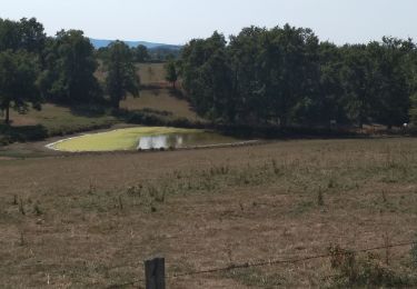
Trail Walking of 10.4 km to be discovered at Auvergne-Rhône-Alpes, Allier, Le Mayet-de-Montagne. This trail is proposed by tracegps.

Description

Départ et arrivée parking plan d'eau de Saint Clément 03250. Longer le plan d'eau par la rive gauche, traverser la route menant à Chatel Montagne, prendre un petit chemin sur la droite le long de la Bresbre, monter en direction de Bletière, redescendre sur la route départementale 207. À l'entrée du bourg du Mayet de Montagne, prendre à gauche sous la station d'épuration puis direction chez Benon, Mauvesin, les Grands Vignauds et le plan d'eau.

Elevation profile

Positioning

Country:
France
Region :
Auvergne-Rhône-Alpes
Department/Province :
Allier
Municipality :
Le Mayet-de-Montagne
Location:
Unknown
Start:(UTM)
553667 ; 5103182 (31T) N.

Trails nearby

Trail Running Châtel-Montagne - jour 7 CAP Jeanot - Photo
Running
jeannat

Running

Very easy
Châtel-Montagne, Auvergne-Rhône-Alpes, Allier, France
33 km | 43 km-effort
4h 29min
No
Trail Walking Châtel-Montagne - Charguéraud a La Croix Bruyère  - Photo
Walking
NANE51

Walking

Easy
Châtel-Montagne, Auvergne-Rhône-Alpes, Allier, France
12.2 km | 16.9 km-effort
3h 9min
No
Trail Walking Châtel-Montagne - Le Puy du Roc - Châtel-Montagne - Photo
Walking
tracegps

Walking

Medium
Châtel-Montagne, Auvergne-Rhône-Alpes, Allier, France
10.2 km | 15.3 km-effort
3h 0min
Yes
Trail Walking Le Mayet-de-Montagne - Saint Clément - Photo
Walking
tracegps

Walking

Difficult
Le Mayet-de-Montagne, Auvergne-Rhône-Alpes, Allier, France
15.9 km | 23 km-effort
3h 30min
Yes
Trail Hybrid bike Châtel-Montagne - jour 7 - Photo
Hybrid bike
nathbab

Hybrid bike

Very easy
Châtel-Montagne, Auvergne-Rhône-Alpes, Allier, France
27 km | 32 km-effort
2h 6min
No
Trail Walking Châtel-Montagne - Balade autour du Mont Aigu - Le Moulin Chatel - Photo
Walking
tracegps

Walking

Medium
Châtel-Montagne, Auvergne-Rhône-Alpes, Allier, France
10.4 km | 14.1 km-effort
2h 30min
Yes
Trail Walking Le Mayet-de-Montagne - Le Grand Roc - Le Mallot - Photo
Walking
tracegps

Walking

Medium
Le Mayet-de-Montagne, Auvergne-Rhône-Alpes, Allier, France
10.4 km | 15.2 km-effort
2h 45min
Yes
Trail Equestrian Saint-Clément - 2024-06-16_20h48m09_st-clement-03250 - Photo
Equestrian
jacky jouve

Equestrian

Medium
Saint-Clément, Auvergne-Rhône-Alpes, Allier, France
30 km | 42 km-effort
Unknown
Yes
Trail Equestrian Saint-Clément - 2024-06-16_20h47m36_Chatel_montagne (1) - Photo
Equestrian
jacky jouve

Equestrian

Medium
Saint-Clément, Auvergne-Rhône-Alpes, Allier, France
25 km | 35 km-effort
Unknown
Yes


Close
My subscriptions