![](/images/other/stat-length.png)
![Trail Walking Breil-sur-Roya - Circuit de Carleva - Photo](https://media.geolcdn.com/t/1900/400/ext.pjpeg?maxdim=2&url=https%3A%2F%2Fstatic1.geolcdn.com%2Fsiteimages%2Fupload%2Ffiles%2F1553511878bg_sport_marche.png)
Circuit de Carleva
domi06
User
![Length](/images/other/stat-length.png)
Length
11.4 km
![Max alt](https://static1.geolcdn.com/siteimages/upload/files/1508320355ic_sort_altitude_max_24dp.png)
Max alt
887 m
![Uphill gradient](https://static1.geolcdn.com/siteimages/upload/files/1508320355ic_sort_den_pos_24dp.png)
Uphill gradient
802 m
![Km-Effort](/images/other/stat-length.png)
Km-Effort
22 km
![Min alt](https://static1.geolcdn.com/siteimages/upload/files/1508320355ic_sort_altitude_min_24dp.png)
Min alt
278 m
![Downhill gradient](https://static1.geolcdn.com/siteimages/upload/files/1508320355ic_sort_den_neg_24dp.png)
Downhill gradient
803 m
![Boucle](https://static1.geolcdn.com/siteimages/upload/files/16400158638029165_repeat_loop_refresh_sync_direction_icon.png)
Boucle
Yes
Creation date :
2019-01-14 17:30:19.746
Updated on :
2019-01-14 17:30:19.746
![Walking](https://static1.geolcdn.com/sitytour/trail-icons/101.png)
4h25
Difficulty : Medium
![Scan this QR Code to open this trail in the SityTrail application](https://capi.geolives.com/qq0zvz2zws4bq2lad0pu/sitytour/trails/1073029/qr.png?size=200)
FREE GPS app for hiking
About
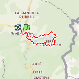
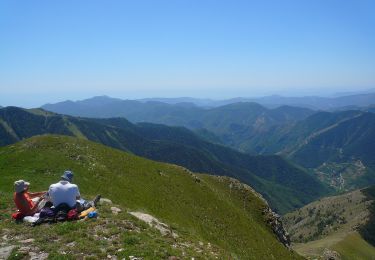
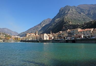
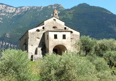
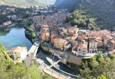
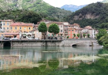
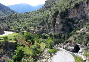
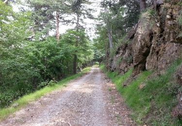
Trail Walking of 11.4 km to be discovered at Provence-Alpes-Côte d'Azur, Maritime Alps, Breil-sur-Roya. This trail is proposed by domi06.
Description
Départ pont inférieur du lac de Breil:B1,longer les fortifications B3,Oratoire B105,prendre à gauche-Serre de Pozzo,Cabanasso.B107-B104
Positioning
Country:
France
Region :
Provence-Alpes-Côte d'Azur
Department/Province :
Maritime Alps
Municipality :
Breil-sur-Roya
Location:
Unknown
Start:(Dec)
Start:(UTM)
380723 ; 4865864 (32T) N.
Comments
Trails nearby
![Trail On foot Breil-sur-Roya - Circuit de la Déa - Photo](https://media.geolcdn.com/t/375/260/15d73491-8abb-4be2-abb9-38a85c62a210.jpeg&format=jpg&maxdim=2)
![On foot On foot](https://static1.geolcdn.com/sitytour/trail-icons/100.png)
Circuit de la Déa
On foot
Medium
Breil-sur-Roya,
Provence-Alpes-Côte d'Azur,
Maritime Alps,
France
![](/images/other/stat-length.png)
14.5 km | 26 km-effort
6h 1min
![](https://static1.geolcdn.com/siteimages/upload/files/16400158638029165_repeat_loop_refresh_sync_direction_icon.png)
Yes
![Trail On foot Breil-sur-Roya - Circuit de la Carleva - Photo](https://media.geolcdn.com/t/375/260/0627645c-5ecc-4822-ad2e-18748ce8a356.jpeg&format=jpg&maxdim=2)
![On foot On foot](https://static1.geolcdn.com/sitytour/trail-icons/100.png)
Circuit de la Carleva
On foot
Medium
Breil-sur-Roya,
Provence-Alpes-Côte d'Azur,
Maritime Alps,
France
![](/images/other/stat-length.png)
11.6 km | 22 km-effort
4h 56min
![](https://static1.geolcdn.com/siteimages/upload/files/16400158638029165_repeat_loop_refresh_sync_direction_icon.png)
Yes
![Trail On foot Breil-sur-Roya - Circuit de Libre - Photo](https://media.geolcdn.com/t/375/260/dcdab34e-1af6-4915-900a-fc3842fda859.jpeg&format=jpg&maxdim=2)
![On foot On foot](https://static1.geolcdn.com/sitytour/trail-icons/100.png)
Circuit de Libre
On foot
Easy
Breil-sur-Roya,
Provence-Alpes-Côte d'Azur,
Maritime Alps,
France
![](/images/other/stat-length.png)
7 km | 14 km-effort
3h 10min
![](https://static1.geolcdn.com/siteimages/upload/files/16400158638029165_repeat_loop_refresh_sync_direction_icon.png)
Yes
![Trail On foot Breil-sur-Roya - Hameau de Piène Haute - Photo](https://media.geolcdn.com/t/375/260/ba7ed6ca-7792-48a5-80e1-bdc0636dfb80.jpeg&format=jpg&maxdim=2)
![On foot On foot](https://static1.geolcdn.com/sitytour/trail-icons/100.png)
Hameau de Piène Haute
On foot
Easy
Breil-sur-Roya,
Provence-Alpes-Côte d'Azur,
Maritime Alps,
France
![](/images/other/stat-length.png)
6.1 km | 12 km-effort
2h 42min
![](https://static1.geolcdn.com/siteimages/upload/files/16400158638029165_repeat_loop_refresh_sync_direction_icon.png)
Yes
![Trail Walking Breil-sur-Roya - Breil-sur-Roya - Notre-Dame du Mont - 2016 06 21 - Photo](https://media.geolcdn.com/t/375/260/ext.jpg?maxdim=2&url=https%3A%2F%2Fservices.sitytrail.com%2FGeolivesWS%2FDownloadMedia.ashx%3FTrailID%3D598710%26Media%3Dfix__20160621171358.jpg)
![Walking Walking](https://static1.geolcdn.com/sitytour/trail-icons/101.png)
Breil-sur-Roya - Notre-Dame du Mont - 2016 06 21
Walking
Easy
Breil-sur-Roya,
Provence-Alpes-Côte d'Azur,
Maritime Alps,
France
![](/images/other/stat-length.png)
4.6 km | 6.8 km-effort
1h 45min
![](https://static1.geolcdn.com/siteimages/upload/files/16400158638029165_repeat_loop_refresh_sync_direction_icon.png)
Yes
![Trail Walking Breil-sur-Roya - Breil-sur-Roya - Piène Haute - Piène Basse - Libre - 2016 06 25 - 1160m 18,5km - Photo](https://media.geolcdn.com/t/375/260/ext.jpg?maxdim=2&url=https%3A%2F%2Fservices.sitytrail.com%2FGeolivesWS%2FDownloadMedia.ashx%3FTrailID%3D598703%26Media%3Dfix__20160625083158.jpg)
![Walking Walking](https://static1.geolcdn.com/sitytour/trail-icons/101.png)
Breil-sur-Roya - Piène Haute - Piène Basse - Libre - 2016 06 25 - 1160m 18,5km
Walking
Difficult
Breil-sur-Roya,
Provence-Alpes-Côte d'Azur,
Maritime Alps,
France
![](/images/other/stat-length.png)
18.5 km | 31 km-effort
6h 50min
![](https://static1.geolcdn.com/siteimages/upload/files/16400158638029165_repeat_loop_refresh_sync_direction_icon.png)
Yes
![Trail Walking Breil-sur-Roya - Breil-sur-Roya - 2016 06 19 - Photo](https://media.geolcdn.com/t/375/260/ext.jpg?maxdim=2&url=https%3A%2F%2Fservices.sitytrail.com%2FGeolivesWS%2FDownloadMedia.ashx%3FTrailID%3D598701%26Media%3Dfix__20160619144915.jpg)
![Walking Walking](https://static1.geolcdn.com/sitytour/trail-icons/101.png)
Breil-sur-Roya - 2016 06 19
Walking
Very easy
Breil-sur-Roya,
Provence-Alpes-Côte d'Azur,
Maritime Alps,
France
![](/images/other/stat-length.png)
4.8 km | 5.6 km-effort
1h 45min
![](https://static1.geolcdn.com/siteimages/upload/files/16400158638029165_repeat_loop_refresh_sync_direction_icon.png)
Yes
![Trail Walking Breil-sur-Roya - Breil-sur-Roya - Sentier Valéen Sud - 2016 06 21 - Photo](https://media.geolcdn.com/t/375/260/ext.jpg?maxdim=2&url=https%3A%2F%2Fservices.sitytrail.com%2FGeolivesWS%2FDownloadMedia.ashx%3FTrailID%3D598699%26Media%3Dfix__20160621154716.jpg)
![Walking Walking](https://static1.geolcdn.com/sitytour/trail-icons/101.png)
Breil-sur-Roya - Sentier Valéen Sud - 2016 06 21
Walking
Very easy
Breil-sur-Roya,
Provence-Alpes-Côte d'Azur,
Maritime Alps,
France
![](/images/other/stat-length.png)
3.2 km | 4.6 km-effort
1h 15min
![](https://static1.geolcdn.com/siteimages/upload/files/16400158638029165_repeat_loop_refresh_sync_direction_icon.png)
Yes
![Trail Walking Breil-sur-Roya - Col de Brouis (Breil-sur-Roya) - cime du Bosc - 2016 06 29 - Photo](https://media.geolcdn.com/t/375/260/ext.jpg?maxdim=2&url=https%3A%2F%2Fservices.sitytrail.com%2FGeolivesWS%2FDownloadMedia.ashx%3FTrailID%3D597960%26Media%3Dfix__20160629161233.jpg)
![Walking Walking](https://static1.geolcdn.com/sitytour/trail-icons/101.png)
Col de Brouis (Breil-sur-Roya) - cime du Bosc - 2016 06 29
Walking
Easy
Breil-sur-Roya,
Provence-Alpes-Côte d'Azur,
Maritime Alps,
France
![](/images/other/stat-length.png)
6.2 km | 9.5 km-effort
1h 40min
![](https://static1.geolcdn.com/siteimages/upload/files/16400158638029165_repeat_loop_refresh_sync_direction_icon.png)
Yes