![](/images/other/stat-length.png)
![Trail Mountain bike Souleuvre-en-Bocage - La petite Besace - Saint Martin des Besaces - Photo](https://media.geolcdn.com/t/1900/400/ext.pjpeg?maxdim=2&url=https%3A%2F%2Fstatic1.geolcdn.com%2Fsiteimages%2Fupload%2Ffiles%2F1524743154velo.jpg)
La petite Besace - Saint Martin des Besaces
tracegps
User
![Length](/images/other/stat-length.png)
Length
37 km
![Max alt](https://static1.geolcdn.com/siteimages/upload/files/1508320355ic_sort_altitude_max_24dp.png)
Max alt
239 m
![Uphill gradient](https://static1.geolcdn.com/siteimages/upload/files/1508320355ic_sort_den_pos_24dp.png)
Uphill gradient
762 m
![Km-Effort](/images/other/stat-length.png)
Km-Effort
47 km
![Min alt](https://static1.geolcdn.com/siteimages/upload/files/1508320355ic_sort_altitude_min_24dp.png)
Min alt
77 m
![Downhill gradient](https://static1.geolcdn.com/siteimages/upload/files/1508320355ic_sort_den_neg_24dp.png)
Downhill gradient
762 m
![Boucle](https://static1.geolcdn.com/siteimages/upload/files/16400158638029165_repeat_loop_refresh_sync_direction_icon.png)
Boucle
Yes
Creation date :
2014-12-10 00:00:00.0
Updated on :
2014-12-10 00:00:00.0
![Mountain bike](https://static1.geolcdn.com/sitytour/trail-icons/202.png)
3h00
Difficulty : Difficult
![Scan this QR Code to open this trail in the SityTrail application](https://capi.geolives.com/qq0zvz2zws4bq2lad0pu/sitytour/trails/107272/qr.png?size=200)
FREE GPS app for hiking
About
Trail Mountain bike of 37 km to be discovered at Normandy, Calvados, Souleuvre-en-Bocage. This trail is proposed by tracegps.
Description
Circuit très sympa avec très peu de passage routier, quelques single tracks sympas et des montées difficiles. Attention circuit pour vététistes confirmés. Bon ride !!!
Positioning
Country:
France
Region :
Normandy
Department/Province :
Calvados
Municipality :
Souleuvre-en-Bocage
Location:
Unknown
Start:(Dec)
Start:(UTM)
657577 ; 5430843 (30U) N.
Comments
Trails nearby
![Trail Mountain bike Souleuvre-en-Bocage - Tour du Bocage Virois - Saint Martin des Besaces - Photo](https://media.geolcdn.com/t/375/260/ext.jpg?maxdim=2&url=https%3A%2F%2Fservices.sitytrail.com%2FGeolivesWS%2FDownloadMedia.ashx%3FTrailID%3D172576%26Media%3D13944_2.jpg)
![Mountain bike Mountain bike](https://static1.geolcdn.com/sitytour/trail-icons/202.png)
Tour du Bocage Virois - Saint Martin des Besaces
Mountain bike
Very difficult
Souleuvre-en-Bocage,
Normandy,
Calvados,
France
![](/images/other/stat-length.png)
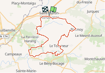
62 km | 78 km-effort
4h 30min
![](https://static1.geolcdn.com/siteimages/upload/files/16400158638029165_repeat_loop_refresh_sync_direction_icon.png)
Yes
![Trail Bicycle tourism Souleuvre-en-Bocage - Activity - Photo](https://media.geolcdn.com/t/375/260/ext.jpg?maxdim=2&url=https%3A%2F%2Fstatic1.geolcdn.com%2Fsiteimages%2Fupload%2Ffiles%2F1524743154velo.jpg)
![Bicycle tourism Bicycle tourism](https://static1.geolcdn.com/sitytour/trail-icons/204.png)
Activity
Bicycle tourism
Medium
Souleuvre-en-Bocage,
Normandy,
Calvados,
France
![](/images/other/stat-length.png)
18.2 km | 21 km-effort
Unknown
![](https://static1.geolcdn.com/siteimages/upload/files/16400158638029165_repeat_loop_refresh_sync_direction_icon.png)
No
![Trail Walking Brémoy - bremoy2 - Photo](https://media.geolcdn.com/t/375/260/ext.jpg?maxdim=2&url=https%3A%2F%2Fstatic1.geolcdn.com%2Fsiteimages%2Fupload%2Ffiles%2F1553511878bg_sport_marche.png)
![Walking Walking](https://static1.geolcdn.com/sitytour/trail-icons/101.png)
![Trail Mountain bike Souleuvre-en-Bocage - La Souleuvre - Saint Martin des Besaces - Photo](https://media.geolcdn.com/t/375/260/ext.jpg?maxdim=2&url=https%3A%2F%2Fstatic1.geolcdn.com%2Fsiteimages%2Fupload%2Ffiles%2F1524743154velo.jpg)
![Mountain bike Mountain bike](https://static1.geolcdn.com/sitytour/trail-icons/202.png)
La Souleuvre - Saint Martin des Besaces
Mountain bike
Very difficult
Souleuvre-en-Bocage,
Normandy,
Calvados,
France
![](/images/other/stat-length.png)
52 km | 67 km-effort
4h 0min
![](https://static1.geolcdn.com/siteimages/upload/files/16400158638029165_repeat_loop_refresh_sync_direction_icon.png)
Yes
![Trail On foot Brémoy - brémoy - Photo](https://media.geolcdn.com/t/375/260/ext.jpg?maxdim=2&url=https%3A%2F%2Fstatic1.geolcdn.com%2Fsiteimages%2Fupload%2Ffiles%2F1545311037marcheuse_200dpi.jpg)
![On foot On foot](https://static1.geolcdn.com/sitytour/trail-icons/100.png)
![Trail 4x4 Souleuvre-en-Bocage - Sortie du samedi 14 mars - Photo](https://media.geolcdn.com/t/375/260/ext.jpg?maxdim=2&url=https%3A%2F%2Fstatic1.geolcdn.com%2Fsiteimages%2Fupload%2Ffiles%2F15247431544x4.jpg)
![4x4 4x4](https://static1.geolcdn.com/sitytour/trail-icons/403.png)
Sortie du samedi 14 mars
4x4
Souleuvre-en-Bocage,
Normandy,
Calvados,
France
![](/images/other/stat-length.png)
63 km | 74 km-effort
2h 31min
![](https://static1.geolcdn.com/siteimages/upload/files/16400158638029165_repeat_loop_refresh_sync_direction_icon.png)
Yes
![Trail 4x4 Souleuvre-en-Bocage - Promenade 3 - Photo](https://media.geolcdn.com/t/375/260/ext.jpg?maxdim=2&url=https%3A%2F%2Fstatic1.geolcdn.com%2Fsiteimages%2Fupload%2Ffiles%2F15247431544x4.jpg)
![4x4 4x4](https://static1.geolcdn.com/sitytour/trail-icons/403.png)
![Trail 4x4 Souleuvre-en-Bocage - Vent Bocage 10 mars 2020 - Photo](https://media.geolcdn.com/t/375/260/ext.jpg?maxdim=2&url=https%3A%2F%2Fstatic1.geolcdn.com%2Fsiteimages%2Fupload%2Ffiles%2F15247431544x4.jpg)
![4x4 4x4](https://static1.geolcdn.com/sitytour/trail-icons/403.png)
Vent Bocage 10 mars 2020
4x4
Souleuvre-en-Bocage,
Normandy,
Calvados,
France
![](/images/other/stat-length.png)
45 km | 57 km-effort
2h 10min
![](https://static1.geolcdn.com/siteimages/upload/files/16400158638029165_repeat_loop_refresh_sync_direction_icon.png)
Yes
![Trail Walking Souleuvre-en-Bocage - St Denis maisoncelles - Photo](https://media.geolcdn.com/t/375/260/ext.jpg?maxdim=2&url=https%3A%2F%2Fstatic1.geolcdn.com%2Fsiteimages%2Fupload%2Ffiles%2F1553511878bg_sport_marche.png)
![Walking Walking](https://static1.geolcdn.com/sitytour/trail-icons/101.png)
St Denis maisoncelles
Walking
Very easy
Souleuvre-en-Bocage,
Normandy,
Calvados,
France
![](/images/other/stat-length.png)
12.9 km | 15.9 km-effort
3h 19min
![](https://static1.geolcdn.com/siteimages/upload/files/16400158638029165_repeat_loop_refresh_sync_direction_icon.png)
Yes