![](/images/other/stat-length.png)
![Trail Walking Pleyben - PLEYBEN - Photo](https://media.geolcdn.com/t/1900/400/ext.pjpeg?maxdim=2&url=https%3A%2F%2Fstatic1.geolcdn.com%2Fsiteimages%2Fupload%2Ffiles%2F1553511878bg_sport_marche.png)
PLEYBEN
RonanDAGORN
User
![Length](/images/other/stat-length.png)
Length
19.7 km
![Max alt](https://static1.geolcdn.com/siteimages/upload/files/1508320355ic_sort_altitude_max_24dp.png)
Max alt
125 m
![Uphill gradient](https://static1.geolcdn.com/siteimages/upload/files/1508320355ic_sort_den_pos_24dp.png)
Uphill gradient
329 m
![Km-Effort](/images/other/stat-length.png)
Km-Effort
24 km
![Min alt](https://static1.geolcdn.com/siteimages/upload/files/1508320355ic_sort_altitude_min_24dp.png)
Min alt
18 m
![Downhill gradient](https://static1.geolcdn.com/siteimages/upload/files/1508320355ic_sort_den_neg_24dp.png)
Downhill gradient
329 m
![Boucle](https://static1.geolcdn.com/siteimages/upload/files/16400158638029165_repeat_loop_refresh_sync_direction_icon.png)
Boucle
Yes
Creation date :
2019-01-15 18:54:28.837
Updated on :
2019-01-15 18:54:28.837
![Walking](https://static1.geolcdn.com/sitytour/trail-icons/101.png)
5h13
Difficulty : Medium
![Scan this QR Code to open this trail in the SityTrail application](https://capi.geolives.com/qq0zvz2zws4bq2lad0pu/sitytour/trails/1072606/qr.png?size=200)
FREE GPS app for hiking
About
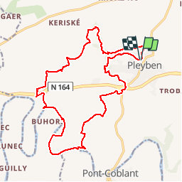
Trail Walking of 19.7 km to be discovered at Brittany, Finistère, Pleyben. This trail is proposed by RonanDAGORN.
Description
3 randonnées partielles cumulées : Circuits de St Laurent Maner Coz Pont Coblant.
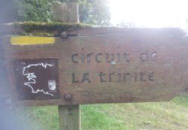
Circuit intéressant malgré qu'il y ait pas mal de bitume
Positioning
Country:
France
Region :
Brittany
Department/Province :
Finistère
Municipality :
Pleyben
Location:
Unknown
Start:(Dec)
Start:(UTM)
427923 ; 5342078 (30U) N.
Comments
Trails nearby
![Trail Walking Pleyben - PLEYBEN - Photo](https://media.geolcdn.com/t/375/260/cae7bee4-aca7-4246-ad2f-a5c3b6f77076.jpg&format=jpg&maxdim=2)
![Walking Walking](https://static1.geolcdn.com/sitytour/trail-icons/101.png)
![Trail Walking Pleyben - pont coblant - Photo](https://media.geolcdn.com/t/375/260/fb1df358-f110-4cbb-8e79-e631d8a0a8f9.jpg&format=jpg&maxdim=2)
![Walking Walking](https://static1.geolcdn.com/sitytour/trail-icons/101.png)
![Trail Walking Pleyben - Pont Coblan à Gouézec et les rives de l'Aulne - Photo](https://media.geolcdn.com/t/375/260/ext.jpg?maxdim=2&url=https%3A%2F%2Fservices.sitytrail.com%2FGeolivesWS%2FDownloadMedia.ashx%3FTrailID%3D109173%26Media%3D3216_1.jpg)
![Walking Walking](https://static1.geolcdn.com/sitytour/trail-icons/101.png)
Pont Coblan à Gouézec et les rives de l'Aulne
Walking
Difficult
Pleyben,
Brittany,
Finistère,
France
![](/images/other/stat-length.png)
20 km | 26 km-effort
4h 0min
![](https://static1.geolcdn.com/siteimages/upload/files/16400158638029165_repeat_loop_refresh_sync_direction_icon.png)
Yes
![Trail Walking Pleyben - PLEYBEN (variante suite Ciaran) - Photo](https://media.geolcdn.com/t/375/260/ext.jpg?maxdim=2&url=https%3A%2F%2Fstatic1.geolcdn.com%2Fsiteimages%2Fupload%2Ffiles%2F1553511878bg_sport_marche.png)
![Walking Walking](https://static1.geolcdn.com/sitytour/trail-icons/101.png)
PLEYBEN (variante suite Ciaran)
Walking
Medium
Pleyben,
Brittany,
Finistère,
France
![](/images/other/stat-length.png)
20 km | 25 km-effort
5h 41min
![](https://static1.geolcdn.com/siteimages/upload/files/16400158638029165_repeat_loop_refresh_sync_direction_icon.png)
No
![Trail Hybrid bike Pleyben - Pont Comblanc Port Carhaix - Photo](https://media.geolcdn.com/t/375/260/6417cd47-48c0-42e3-bed8-7eb80f8cce6f.jpg&format=jpg&maxdim=2)
![Hybrid bike Hybrid bike](https://static1.geolcdn.com/sitytour/trail-icons/203.png)
Pont Comblanc Port Carhaix
Hybrid bike
Easy
Pleyben,
Brittany,
Finistère,
France
![](/images/other/stat-length.png)
61 km | 72 km-effort
3h 27min
![](https://static1.geolcdn.com/siteimages/upload/files/16400158638029165_repeat_loop_refresh_sync_direction_icon.png)
No
![Trail Walking Pleyben - PLEYBEN - Photo](https://media.geolcdn.com/t/375/260/ext.jpg?maxdim=2&url=https%3A%2F%2Fstatic1.geolcdn.com%2Fsiteimages%2Fupload%2Ffiles%2F1553511878bg_sport_marche.png)
![Walking Walking](https://static1.geolcdn.com/sitytour/trail-icons/101.png)
![Trail Walking Gouézec - Pont Coblant - Photo](https://media.geolcdn.com/t/375/260/ext.jpg?maxdim=2&url=https%3A%2F%2Fstatic1.geolcdn.com%2Fsiteimages%2Fupload%2Ffiles%2F1553511878bg_sport_marche.png)
![Walking Walking](https://static1.geolcdn.com/sitytour/trail-icons/101.png)
![Trail Walking Gouézec - Canal Nantes/Brest à Lennon - Photo](https://media.geolcdn.com/t/375/260/ext.jpg?maxdim=2&url=https%3A%2F%2Fstatic1.geolcdn.com%2Fsiteimages%2Fupload%2Ffiles%2F1553511878bg_sport_marche.png)
![Walking Walking](https://static1.geolcdn.com/sitytour/trail-icons/101.png)
Canal Nantes/Brest à Lennon
Walking
Very easy
Gouézec,
Brittany,
Finistère,
France
![](/images/other/stat-length.png)
10.2 km | 12.1 km-effort
2h 32min
![](https://static1.geolcdn.com/siteimages/upload/files/16400158638029165_repeat_loop_refresh_sync_direction_icon.png)
Yes
![Trail Walking Pleyben - tachenic - Photo](https://media.geolcdn.com/t/375/260/ext.jpg?maxdim=2&url=https%3A%2F%2Fstatic1.geolcdn.com%2Fsiteimages%2Fupload%2Ffiles%2F1553511878bg_sport_marche.png)
![Walking Walking](https://static1.geolcdn.com/sitytour/trail-icons/101.png)