![](/images/other/stat-length.png)
![Trail Walking Saint-Aubin-de-Crétot - St Aubin de Crétot - Photo](https://media.geolcdn.com/t/1900/400/ext.pjpeg?maxdim=2&url=https%3A%2F%2Fservices.sitytrail.com%2FGeolivesWS%2FDownloadMedia.ashx%3FTrailID%3D107050%26Media%3D11860_1.jpg)
St Aubin de Crétot
tracegps
User
![Length](/images/other/stat-length.png)
Length
17.8 km
![Max alt](https://static1.geolcdn.com/siteimages/upload/files/1508320355ic_sort_altitude_max_24dp.png)
Max alt
148 m
![Uphill gradient](https://static1.geolcdn.com/siteimages/upload/files/1508320355ic_sort_den_pos_24dp.png)
Uphill gradient
356 m
![Km-Effort](/images/other/stat-length.png)
Km-Effort
23 km
![Min alt](https://static1.geolcdn.com/siteimages/upload/files/1508320355ic_sort_altitude_min_24dp.png)
Min alt
26 m
![Downhill gradient](https://static1.geolcdn.com/siteimages/upload/files/1508320355ic_sort_den_neg_24dp.png)
Downhill gradient
351 m
![Boucle](https://static1.geolcdn.com/siteimages/upload/files/16400158638029165_repeat_loop_refresh_sync_direction_icon.png)
Boucle
No
Creation date :
2014-12-10 00:00:00.0
Updated on :
2014-12-10 00:00:00.0
![Walking](https://static1.geolcdn.com/sitytour/trail-icons/101.png)
3h40
Difficulty : Medium
![Scan this QR Code to open this trail in the SityTrail application](https://capi.geolives.com/qq0zvz2zws4bq2lad0pu/sitytour/trails/107050/qr.png?size=200)
FREE GPS app for hiking
About
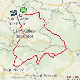
Trail Walking of 17.8 km to be discovered at Normandy, Seine-Maritime, Saint-Aubin-de-Crétot. This trail is proposed by tracegps.
Description
Un balade très agréable où alternent les dénivelés qui découvrent les paysages de la campagne du pays de Caux et ceux de la forêt domaniale du Trait-Maulévrier.
Positioning
Country:
France
Region :
Normandy
Department/Province :
Seine-Maritime
Municipality :
Saint-Aubin-de-Crétot
Location:
Unknown
Start:(Dec)
Start:(UTM)
329250 ; 5493511 (31U) N.
Comments
Trails nearby
![Trail Walking Allouville-Bellefosse - allouille bellefosse - Photo](https://media.geolcdn.com/t/375/260/ext.jpg?maxdim=2&url=https%3A%2F%2Fstatic1.geolcdn.com%2Fsiteimages%2Fupload%2Ffiles%2F1553511878bg_sport_marche.png)
![Walking Walking](https://static1.geolcdn.com/sitytour/trail-icons/101.png)
allouille bellefosse
Walking
Very easy
(2)
Allouville-Bellefosse,
Normandy,
Seine-Maritime,
France
![](/images/other/stat-length.png)
10.4 km | 12.6 km-effort
2h 30min
![](https://static1.geolcdn.com/siteimages/upload/files/16400158638029165_repeat_loop_refresh_sync_direction_icon.png)
Yes
![Trail Walking Allouville-Bellefosse - Allouville -Bellefosse - Photo](https://media.geolcdn.com/t/375/260/48ea2f08-2bb6-4cc5-be17-998a80c9c4f7.jpg&format=jpg&maxdim=2)
![Walking Walking](https://static1.geolcdn.com/sitytour/trail-icons/101.png)
Allouville -Bellefosse
Walking
Difficult
(1)
Allouville-Bellefosse,
Normandy,
Seine-Maritime,
France
![](/images/other/stat-length.png)
10.3 km | 12.5 km-effort
2h 52min
![](https://static1.geolcdn.com/siteimages/upload/files/16400158638029165_repeat_loop_refresh_sync_direction_icon.png)
Yes
![Trail Walking Maulévrier-Sainte-Gertrude - Maulévrier-Sainte-Gertrude (144) - Photo](https://media.geolcdn.com/t/375/260/ext.jpg?maxdim=2&url=https%3A%2F%2Fstatic1.geolcdn.com%2Fsiteimages%2Fupload%2Ffiles%2F1553511878bg_sport_marche.png)
![Walking Walking](https://static1.geolcdn.com/sitytour/trail-icons/101.png)
Maulévrier-Sainte-Gertrude (144)
Walking
Difficult
Maulévrier-Sainte-Gertrude,
Normandy,
Seine-Maritime,
France
![](/images/other/stat-length.png)
12.1 km | 17.1 km-effort
3h 53min
![](https://static1.geolcdn.com/siteimages/upload/files/16400158638029165_repeat_loop_refresh_sync_direction_icon.png)
Yes
![Trail Walking Allouville-Bellefosse - Allouville Bellefosse 25/08/2024 - Photo](https://media.geolcdn.com/t/375/260/ext.jpg?maxdim=2&url=https%3A%2F%2Fstatic1.geolcdn.com%2Fsiteimages%2Fupload%2Ffiles%2F1553511878bg_sport_marche.png)
![Walking Walking](https://static1.geolcdn.com/sitytour/trail-icons/101.png)
Allouville Bellefosse 25/08/2024
Walking
Difficult
Allouville-Bellefosse,
Normandy,
Seine-Maritime,
France
![](/images/other/stat-length.png)
10.6 km | 12.8 km-effort
2h 54min
![](https://static1.geolcdn.com/siteimages/upload/files/16400158638029165_repeat_loop_refresh_sync_direction_icon.png)
Yes
![Trail Walking Maulévrier-Sainte-Gertrude - ste gertrude - Photo](https://media.geolcdn.com/t/375/260/ext.jpg?maxdim=2&url=https%3A%2F%2Fstatic1.geolcdn.com%2Fsiteimages%2Fupload%2Ffiles%2F1553511878bg_sport_marche.png)
![Walking Walking](https://static1.geolcdn.com/sitytour/trail-icons/101.png)
ste gertrude
Walking
Very easy
Maulévrier-Sainte-Gertrude,
Normandy,
Seine-Maritime,
France
![](/images/other/stat-length.png)
7.1 km | 10.4 km-effort
2h 22min
![](https://static1.geolcdn.com/siteimages/upload/files/16400158638029165_repeat_loop_refresh_sync_direction_icon.png)
Yes
![Trail On foot Saint-Gilles-de-Crétot - Saint Gilles de Crétot - Photo](https://media.geolcdn.com/t/375/260/ext.jpg?maxdim=2&url=https%3A%2F%2Fstatic1.geolcdn.com%2Fsiteimages%2Fupload%2Ffiles%2F1545311037marcheuse_200dpi.jpg)
![On foot On foot](https://static1.geolcdn.com/sitytour/trail-icons/100.png)
Saint Gilles de Crétot
On foot
Easy
Saint-Gilles-de-Crétot,
Normandy,
Seine-Maritime,
France
![](/images/other/stat-length.png)
6.1 km | 7.5 km-effort
1h 30min
![](https://static1.geolcdn.com/siteimages/upload/files/16400158638029165_repeat_loop_refresh_sync_direction_icon.png)
Yes
![Trail On foot Allouville-Bellefosse - Le Chêne d'Allouville - Photo](https://media.geolcdn.com/t/375/260/ext.jpg?maxdim=2&url=https%3A%2F%2Fstatic1.geolcdn.com%2Fsiteimages%2Fupload%2Ffiles%2F1545311037marcheuse_200dpi.jpg)
![On foot On foot](https://static1.geolcdn.com/sitytour/trail-icons/100.png)
Le Chêne d'Allouville
On foot
Easy
Allouville-Bellefosse,
Normandy,
Seine-Maritime,
France
![](/images/other/stat-length.png)
10.2 km | 11.9 km-effort
2h 30min
![](https://static1.geolcdn.com/siteimages/upload/files/16400158638029165_repeat_loop_refresh_sync_direction_icon.png)
Yes
![Trail Walking Maulévrier-Sainte-Gertrude - GR-Le Chêne Saint Pierre - Photo](https://media.geolcdn.com/t/375/260/ext.jpg?maxdim=2&url=https%3A%2F%2Fstatic1.geolcdn.com%2Fsiteimages%2Fupload%2Ffiles%2F1553511878bg_sport_marche.png)
![Walking Walking](https://static1.geolcdn.com/sitytour/trail-icons/101.png)
GR-Le Chêne Saint Pierre
Walking
Difficult
(1)
Maulévrier-Sainte-Gertrude,
Normandy,
Seine-Maritime,
France
![](/images/other/stat-length.png)
9.6 km | 13.3 km-effort
3h 0min
![](https://static1.geolcdn.com/siteimages/upload/files/16400158638029165_repeat_loop_refresh_sync_direction_icon.png)
Yes
![Trail Walking Maulévrier-Sainte-Gertrude - PR-Le Chêne Saint Pierre - Photo](https://media.geolcdn.com/t/375/260/ext.jpg?maxdim=2&url=https%3A%2F%2Fstatic1.geolcdn.com%2Fsiteimages%2Fupload%2Ffiles%2F1553511878bg_sport_marche.png)
![Walking Walking](https://static1.geolcdn.com/sitytour/trail-icons/101.png)
PR-Le Chêne Saint Pierre
Walking
Medium
Maulévrier-Sainte-Gertrude,
Normandy,
Seine-Maritime,
France
![](/images/other/stat-length.png)
7.2 km | 9.9 km-effort
2h 30min
![](https://static1.geolcdn.com/siteimages/upload/files/16400158638029165_repeat_loop_refresh_sync_direction_icon.png)
Yes