Trail Walking Ganagobie - Plateau de Ganagobie - Photo
 tracegps
tracegps

User

© OpenStreetMap contributors
Length
Length
7.6 km
Max alt
Max alt
708 m
Uphill gradient
Uphill gradient
245 m
Km-Effort
Km-Effort  
10.9 km
Min alt
Min alt
538 m
Downhill gradient
Downhill gradient
244 m
Boucle
Boucle
Yes
Creation date :
2014-12-10 00:00:00.0
Updated on :
2014-12-10 00:00:00.0

(2 Reviews)

Walking
Walking
3h00
Difficulty : Medium

Scan this QR Code to open this trail in the SityTrail application

FREE GPS app for hiking

Logo SityTrail SityTrail

IGN / Geographical institutes

Download SityTrail from the App Store Download SityTrail from Google Play

Logo SityTrail SityTrail World

The world is yours!

Download SityTrail from the App Store Download SityTrail from Google Play Download SityTrail on Huawei AppGallery

About

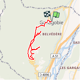
Trail Walking of 7.6 km to be discovered at Provence-Alpes-Côte d'Azur, Alpes-de-Haute-Provence, Ganagobie. This trail is proposed by tracegps.

Description

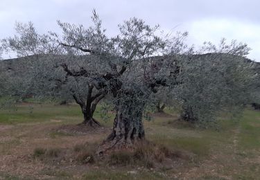
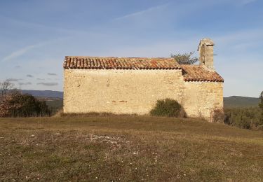
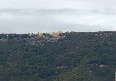
Départ au village de Ganagobie, devant la mairie, montée vers le plateau, tour du plateau par l'ouest en passant par la Fontaine aux Oiseaux, le chemin de Forcalquier, la vue sur Lurs, le parking, la boutique, l'église, la croix, la ville vieille et retour au départ. On monte au début puis l'ensemble se fait sur du plat relatif et puis la descente. C'est une courte rando à faire le matin pour prendre le pique-nique au lac du parc d'activité des Mées (7 km) et faire la randonnée des Pénitents (Les Mées également) l'après-midi.

Elevation profile

Photos

Points of interest

Point of interest Ganagobie - Arrivée au Plateau - Photo
tracegps
Point of interest Ganagobie - Arrivée Ganagobie - Photo
tracegps
Point of interest Ganagobie - Bifurcation Monticelli - Photo
tracegps
Point of interest Ganagobie - Boutique - Photo
tracegps
GANAGOBIE 
Point of interest Ganagobie - Chemin de Forcalquier - Photo
tracegps
Point of interest Ganagobie - Croix (vue superbe) - Photo
tracegps
Point of interest Ganagobie - Départ Ganagobie - Photo
tracegps
Point of interest Ganagobie - Eglise - Photo
tracegps
GANAGOBIE 
Point of interest Ganagobie - Fontaine aux Oiseaux - Photo
tracegps
Point of interest Ganagobie - Parking - Photo
tracegps
GANAGOBIE 
Point of interest Ganagobie - Ville Vieille - Photo
tracegps
GANAGOBIE 
Point of interest Ganagobie - Vue sur Lurs - Photo
tracegps
GANAGOBIE 

Positioning

Country:
France
Region :
Provence-Alpes-Côte d'Azur
Department/Province :
Alpes-de-Haute-Provence
Municipality :
Ganagobie
Location:
Unknown
Start:(UTM)
733817 ; 4877051 (31T) N.

Comments

Please log in to post a review or rate the element


Super mini rando paysages magnifiques et aspect culturel avec monastere


balade sympathique. beau panorama


Trails nearby

Trail Walking Lurs - LURS  Visite et tour de Lurs o l m s  - Photo
Walking
GUIDE
RobinMicheline

Walking

Medium
(2)
Lurs, Provence-Alpes-Côte d'Azur, Alpes-de-Haute-Provence, France
11.1 km | 15.6 km-effort
3h 17min
Yes
Trail Walking Ganagobie - GANAGOBIE  . Tour par le bas . Visite Ganagobie  o  m s  - Photo
Walking
GUIDE
RobinMicheline

Walking

Medium
(1)
Ganagobie, Provence-Alpes-Côte d'Azur, Alpes-de-Haute-Provence, France
14.6 km | 21 km-effort
3h 55min
Yes
Trail Walking Les Mées - 2023-04-14 Les Apollinaires- Haute montagne - Les Pénitents  - Photo
Walking
GUIDE
Kargil

Walking

Medium
Les Mées, Provence-Alpes-Côte d'Azur, Alpes-de-Haute-Provence, France
17.5 km | 26 km-effort
5h 49min
Yes
Trail Walking Lurs - ganagobie - Photo
Walking
GUIDE
MicDul

Walking

Very difficult
Lurs, Provence-Alpes-Côte d'Azur, Alpes-de-Haute-Provence, France
15.9 km | 23 km-effort
5h 17min
Yes
Trail Walking Les Mées - LES MEES .Chapelle St Pierre , la Bressanne , la Bessonne o l s - Photo
Walking
GUIDE
RobinMicheline

Walking

Easy
Les Mées, Provence-Alpes-Côte d'Azur, Alpes-de-Haute-Provence, France
14.8 km | 19.8 km-effort
3h 23min
Yes
Trail On foot Lurs - LURS . bois du Crepon , Notre dame du Plan , la Casse o - Photo
On foot
GUIDE
RobinMicheline

On foot

Medium
Lurs, Provence-Alpes-Côte d'Azur, Alpes-de-Haute-Provence, France
14.3 km | 18.6 km-effort
Unknown
Yes
Trail Mountain bike Lurs - Lurs/Tour de la Beaume - Photo
Mountain bike
remizzi

Mountain bike

Medium
(2)
Lurs, Provence-Alpes-Côte d'Azur, Alpes-de-Haute-Provence, France
18.5 km | 24 km-effort
2h 40min
Yes
Trail Running Peyruis - trail 29 07 2013 - Photo
Running
zapi

Running

Medium
(1)
Peyruis, Provence-Alpes-Côte d'Azur, Alpes-de-Haute-Provence, France
13.5 km | 20 km-effort
1h 27min
Yes
Trail Walking Les Mées - Balade des vergers - Photo
Walking
AnneGeorges

Walking

Medium
Les Mées, Provence-Alpes-Côte d'Azur, Alpes-de-Haute-Provence, France
5 km | 6 km-effort
1h 37min
Yes


Close
My subscriptions