![](/images/other/stat-length.png)
![Trail Mountain bike Francheville - Raid VTT Monts du Lyonnais - Francheville - Photo](https://media.geolcdn.com/t/1900/400/ext.pjpeg?maxdim=2&url=https%3A%2F%2Fstatic1.geolcdn.com%2Fsiteimages%2Fupload%2Ffiles%2F1524743154velo.jpg)
Raid VTT Monts du Lyonnais - Francheville
tracegps
User
![Length](/images/other/stat-length.png)
Length
67 km
![Max alt](https://static1.geolcdn.com/siteimages/upload/files/1508320355ic_sort_altitude_max_24dp.png)
Max alt
858 m
![Uphill gradient](https://static1.geolcdn.com/siteimages/upload/files/1508320355ic_sort_den_pos_24dp.png)
Uphill gradient
1809 m
![Km-Effort](/images/other/stat-length.png)
Km-Effort
91 km
![Min alt](https://static1.geolcdn.com/siteimages/upload/files/1508320355ic_sort_altitude_min_24dp.png)
Min alt
193 m
![Downhill gradient](https://static1.geolcdn.com/siteimages/upload/files/1508320355ic_sort_den_neg_24dp.png)
Downhill gradient
1809 m
![Boucle](https://static1.geolcdn.com/siteimages/upload/files/16400158638029165_repeat_loop_refresh_sync_direction_icon.png)
Boucle
Yes
Creation date :
2014-12-10 00:00:00.0
Updated on :
2014-12-10 00:00:00.0
![Mountain bike](https://static1.geolcdn.com/sitytour/trail-icons/202.png)
6h00
Difficulty : Difficult
![Scan this QR Code to open this trail in the SityTrail application](https://capi.geolives.com/qq0zvz2zws4bq2lad0pu/sitytour/trails/107027/qr.png?size=200)
FREE GPS app for hiking
About
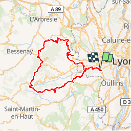
Trail Mountain bike of 67 km to be discovered at Auvergne-Rhône-Alpes, Métropole de Lyon, Francheville. This trail is proposed by tracegps.
Description
Parcours au départ de Francheville. Ne pas laisser toute ces forces dans les premiers km, le chemin est long et n'arrête pas de descendre et de monter jusqu'au Crêt de la Madone. Ensuite une belle descente où on peut ouvrir jusqu'à Francheville.
Positioning
Country:
France
Region :
Auvergne-Rhône-Alpes
Department/Province :
Métropole de Lyon
Municipality :
Francheville
Location:
Unknown
Start:(Dec)
Start:(UTM)
637781 ; 5066955 (31T) N.
Comments
Trails nearby
![Trail Walking Craponne - départ cimetière de Craponne - Photo](https://media.geolcdn.com/t/375/260/69d5a206-99fc-4c26-ba2a-07de4fc87322.jpg&format=jpg&maxdim=2)
![Walking Walking](https://static1.geolcdn.com/sitytour/trail-icons/101.png)
départ cimetière de Craponne
Walking
Easy
(1)
Craponne,
Auvergne-Rhône-Alpes,
Métropole de Lyon,
France
![](/images/other/stat-length.png)
10.3 km | 13.1 km-effort
2h 36min
![](https://static1.geolcdn.com/siteimages/upload/files/16400158638029165_repeat_loop_refresh_sync_direction_icon.png)
Yes
![Trail Mountain bike Lyon - Mont Verdun - Photo](https://media.geolcdn.com/t/375/260/ext.jpg?maxdim=2&url=https%3A%2F%2Fservices.sitytrail.com%2FGeolivesWS%2FDownloadMedia.ashx%3FTrailID%3D101348%26Media%3D948_1.jpg)
![Mountain bike Mountain bike](https://static1.geolcdn.com/sitytour/trail-icons/202.png)
Mont Verdun
Mountain bike
Difficult
(2)
Lyon,
Auvergne-Rhône-Alpes,
Métropole de Lyon,
France
![](/images/other/stat-length.png)
29 km | 37 km-effort
2h 15min
![](https://static1.geolcdn.com/siteimages/upload/files/16400158638029165_repeat_loop_refresh_sync_direction_icon.png)
Yes
![Trail Walking Lyon - De Place des Archives à Monplaisir - Photo](https://media.geolcdn.com/t/375/260/ext.jpg?maxdim=2&url=https%3A%2F%2Fstatic1.geolcdn.com%2Fsiteimages%2Fupload%2Ffiles%2F1553511878bg_sport_marche.png)
![Walking Walking](https://static1.geolcdn.com/sitytour/trail-icons/101.png)
De Place des Archives à Monplaisir
Walking
Difficult
(1)
Lyon,
Auvergne-Rhône-Alpes,
Métropole de Lyon,
France
![](/images/other/stat-length.png)
11.2 km | 12.9 km-effort
2h 55min
![](https://static1.geolcdn.com/siteimages/upload/files/16400158638029165_repeat_loop_refresh_sync_direction_icon.png)
No
![Trail Walking Lyon - Croix-Rousse / la Tête d'Or - Photo](https://media.geolcdn.com/t/375/260/7d40af9e-9bd9-42ef-a0fe-88b64a87f428.jpg&format=jpg&maxdim=2)
![Walking Walking](https://static1.geolcdn.com/sitytour/trail-icons/101.png)
Croix-Rousse / la Tête d'Or
Walking
Very easy
Lyon,
Auvergne-Rhône-Alpes,
Métropole de Lyon,
France
![](/images/other/stat-length.png)
8.8 km | 10.2 km-effort
2h 23min
![](https://static1.geolcdn.com/siteimages/upload/files/16400158638029165_repeat_loop_refresh_sync_direction_icon.png)
No
![Trail Walking Francheville - Aqueduc et fort du Bruissin (PR1) - Photo](https://media.geolcdn.com/t/375/260/3e156afe-0a53-4173-8a16-0a0e11f72681.jpg&format=jpg&maxdim=2)
![Walking Walking](https://static1.geolcdn.com/sitytour/trail-icons/101.png)
Aqueduc et fort du Bruissin (PR1)
Walking
Easy
Francheville,
Auvergne-Rhône-Alpes,
Métropole de Lyon,
France
![](/images/other/stat-length.png)
19.1 km | 23 km-effort
5h 20min
![](https://static1.geolcdn.com/siteimages/upload/files/16400158638029165_repeat_loop_refresh_sync_direction_icon.png)
Yes
![Trail Walking Craponne - de Craponne à Brindas . - Photo](https://media.geolcdn.com/t/375/260/c4387d92-62eb-4940-8168-b397ca0a6564.jpg&format=jpg&maxdim=2)
![Walking Walking](https://static1.geolcdn.com/sitytour/trail-icons/101.png)
de Craponne à Brindas .
Walking
Medium
Craponne,
Auvergne-Rhône-Alpes,
Métropole de Lyon,
France
![](/images/other/stat-length.png)
9.5 km | 11.5 km-effort
2h 8min
![](https://static1.geolcdn.com/siteimages/upload/files/16400158638029165_repeat_loop_refresh_sync_direction_icon.png)
Yes
![Trail Walking Chaponost - de Chaponost à Brignais AR - Photo](https://media.geolcdn.com/t/375/260/748757ec-45c0-4bb1-82f9-93d25db52f90.jpg&format=jpg&maxdim=2)
![Walking Walking](https://static1.geolcdn.com/sitytour/trail-icons/101.png)
de Chaponost à Brignais AR
Walking
Difficult
Chaponost,
Auvergne-Rhône-Alpes,
Rhône,
France
![](/images/other/stat-length.png)
11.8 km | 14.3 km-effort
2h 40min
![](https://static1.geolcdn.com/siteimages/upload/files/16400158638029165_repeat_loop_refresh_sync_direction_icon.png)
Yes
![Trail Walking Chaponost - Chaponost boucle - Photo](https://media.geolcdn.com/t/375/260/b687906a-573a-4707-b2a1-585e616585f2.jpg&format=jpg&maxdim=2)
![Walking Walking](https://static1.geolcdn.com/sitytour/trail-icons/101.png)
Chaponost boucle
Walking
Medium
Chaponost,
Auvergne-Rhône-Alpes,
Rhône,
France
![](/images/other/stat-length.png)
9.2 km | 11.2 km-effort
1h 56min
![](https://static1.geolcdn.com/siteimages/upload/files/16400158638029165_repeat_loop_refresh_sync_direction_icon.png)
Yes
![Trail Walking Chaponost - Acqueducs de Chaponost à Beaunant - Photo](https://media.geolcdn.com/t/375/260/ef970cfb-3fa6-4f76-aabf-a3009ce76612.jpg&format=jpg&maxdim=2)
![Walking Walking](https://static1.geolcdn.com/sitytour/trail-icons/101.png)
Acqueducs de Chaponost à Beaunant
Walking
Medium
Chaponost,
Auvergne-Rhône-Alpes,
Rhône,
France
![](/images/other/stat-length.png)
7 km | 9.2 km-effort
1h 35min
![](https://static1.geolcdn.com/siteimages/upload/files/16400158638029165_repeat_loop_refresh_sync_direction_icon.png)
Yes