Trail Mountain bike Chamaloc - Descente du plateau du Vercors par le col de Vassieux - Chamaloc - Photo

Descente du plateau du Vercors par le col de Vassieux - Chamaloc

 tracegps
tracegps

User

© OpenStreetMap contributors
Length
Length
27 km
Max alt
Max alt
1544 m
Uphill gradient
Uphill gradient
1097 m
Km-Effort
Km-Effort  
42 km
Min alt
Min alt
510 m
Downhill gradient
Downhill gradient
1119 m
Boucle
Boucle
No
Creation date :
2014-12-10 00:00:00.0
Updated on :
2014-12-10 00:00:00.0

(0 Reviews)

Mountain bike
Mountain bike
2h30
Difficulty : Difficult

Scan this QR Code to open this trail in the SityTrail application

FREE GPS app for hiking

Logo SityTrail SityTrail

IGN / Geographical institutes

Download SityTrail from the App Store Download SityTrail from Google Play

Logo SityTrail SityTrail World

The world is yours!

Download SityTrail from the App Store Download SityTrail from Google Play Download SityTrail on Huawei AppGallery

About

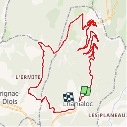
Trail Mountain bike of 27 km to be discovered at Auvergne-Rhône-Alpes, Drôme, Chamaloc. This trail is proposed by tracegps.

Description

La montée se fait par la route en direction du col de Rousset. Prévoir une bonne heure, ensuite sur les crêtes le paysage est magnifique. Le col de Vassieux arrive très vite. Attention sortie pour les vttistes confirmés.

Elevation profile

Positioning

Country:
France
Region :
Auvergne-Rhône-Alpes
Department/Province :
Drôme
Municipality :
Chamaloc
Location:
Unknown
Start:(UTM)
688633 ; 4963453 (31T) N.

Trails nearby

Trail Snowshoes Vassieux-en-Vercors - Col de Vassieux - Photo
Snowshoes
tracegps

Snowshoes

Easy
(1)
Vassieux-en-Vercors, Auvergne-Rhône-Alpes, Drôme, France
7.6 km | 10.8 km-effort
3h 0min
Yes
Trail Mountain bike Chamaloc - Chamaloc - Hauteurs de Die - Photo
Mountain bike
tracegps

Mountain bike

Difficult
(1)
Chamaloc, Auvergne-Rhône-Alpes, Drôme, France
36 km | 50 km-effort
3h 0min
Yes
Trail Walking Saint-Agnan-en-Vercors - jour 1 Sommet de Peyre rouge  - Photo
Walking
GUIDE
nadd73

Walking

Medium
Saint-Agnan-en-Vercors, Auvergne-Rhône-Alpes, Drôme, France
13.7 km | 23 km-effort
5h 7min
No
Trail Walking Chamaloc - Col de Chirone et refuge de Vassieux  - Photo
Walking
GUIDE
thonyc

Walking

Very difficult
Chamaloc, Auvergne-Rhône-Alpes, Drôme, France
13.7 km | 21 km-effort
4h 52min
Yes
Trail Walking Saint-Agnan-en-Vercors - Sentier de l'Ours du Vercors - Photo
Walking
dhommee

Walking

Medium
(1)
Saint-Agnan-en-Vercors, Auvergne-Rhône-Alpes, Drôme, France
6.8 km | 10.9 km-effort
2h 28min
Yes
Trail Walking Romeyer - La rive du rocher des heures - Photo
Walking
GUIDE
nadd73

Walking

Difficult
Romeyer, Auvergne-Rhône-Alpes, Drôme, France
19.5 km | 34 km-effort
5h 31min
No
Trail Walking Marignac-en-Diois - 26 marignac en diois/desse/but richaude - Photo
Walking
GUIDE
randodyssée

Walking

Medium
(1)
Marignac-en-Diois, Auvergne-Rhône-Alpes, Drôme, France
14.8 km | 24 km-effort
6h 29min
Yes
Trail Walking Die - Col de Bergu  - Photo
Walking
Fky78

Walking

Medium
Die, Auvergne-Rhône-Alpes, Drôme, France
6.2 km | 10.2 km-effort
2h 15min
Yes
Trail Walking Romeyer - Romeyer - Col des Bachassons - Le Pison - Le Château - Photo
Walking
Philindy26

Walking

Difficult
Romeyer, Auvergne-Rhône-Alpes, Drôme, France
15.6 km | 28 km-effort
5h 30min
Yes


Close
My subscriptions