![](/images/other/stat-length.png)
![Trail Walking Rieux - Les trois bosses - Rieux - Photo](https://media.geolcdn.com/t/1900/400/ext.pjpeg?maxdim=2&url=https%3A%2F%2Fstatic1.geolcdn.com%2Fsiteimages%2Fupload%2Ffiles%2F1553511878bg_sport_marche.png)
Les trois bosses - Rieux
tracegps
User
![Length](/images/other/stat-length.png)
Length
10.2 km
![Max alt](https://static1.geolcdn.com/siteimages/upload/files/1508320355ic_sort_altitude_max_24dp.png)
Max alt
109 m
![Uphill gradient](https://static1.geolcdn.com/siteimages/upload/files/1508320355ic_sort_den_pos_24dp.png)
Uphill gradient
230 m
![Km-Effort](/images/other/stat-length.png)
Km-Effort
13.2 km
![Min alt](https://static1.geolcdn.com/siteimages/upload/files/1508320355ic_sort_altitude_min_24dp.png)
Min alt
29 m
![Downhill gradient](https://static1.geolcdn.com/siteimages/upload/files/1508320355ic_sort_den_neg_24dp.png)
Downhill gradient
231 m
![Boucle](https://static1.geolcdn.com/siteimages/upload/files/16400158638029165_repeat_loop_refresh_sync_direction_icon.png)
Boucle
Yes
Creation date :
2014-12-10 00:00:00.0
Updated on :
2014-12-10 00:00:00.0
![Walking](https://static1.geolcdn.com/sitytour/trail-icons/101.png)
2h49
Difficulty : Difficult
![Scan this QR Code to open this trail in the SityTrail application](https://capi.geolives.com/qq0zvz2zws4bq2lad0pu/sitytour/trails/106949/qr.png?size=200)
FREE GPS app for hiking
About
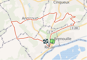
Trail Walking of 10.2 km to be discovered at Hauts-de-France, Oise, Rieux. This trail is proposed by tracegps.
Description
Comme son nom l'indique, il y a trois bosses à franchir. A Angicourt, admirez l'Église Saint-Vaast d'Angicourt de style gothique commencée au XIIe siècle et terminée dans le courant du XIIIe siècle.
Positioning
Country:
France
Region :
Hauts-de-France
Department/Province :
Oise
Municipality :
Rieux
Location:
Unknown
Start:(Dec)
Start:(UTM)
464992 ; 5460765 (31U) N.
Comments
Trails nearby
![Trail Walking Beaurepaire - La mare aux oiseaux - Beaurepaire - Photo](https://media.geolcdn.com/t/375/260/ext.jpg?maxdim=2&url=https%3A%2F%2Fservices.sitytrail.com%2FGeolivesWS%2FDownloadMedia.ashx%3FTrailID%3D172831%26Media%3D14265_3.jpg)
![Walking Walking](https://static1.geolcdn.com/sitytour/trail-icons/101.png)
La mare aux oiseaux - Beaurepaire
Walking
Medium
(1)
Beaurepaire,
Hauts-de-France,
Oise,
France
![](/images/other/stat-length.png)
8.4 km | 10.2 km-effort
2h 10min
![](https://static1.geolcdn.com/siteimages/upload/files/16400158638029165_repeat_loop_refresh_sync_direction_icon.png)
Yes
![Trail Walking Fleurines - Fleurines Grand parcours - Photo](https://media.geolcdn.com/t/375/260/ext.jpg?maxdim=2&url=https%3A%2F%2Fstatic1.geolcdn.com%2Fsiteimages%2Fupload%2Ffiles%2F1553511878bg_sport_marche.png)
![Walking Walking](https://static1.geolcdn.com/sitytour/trail-icons/101.png)
Fleurines Grand parcours
Walking
Easy
(1)
Fleurines,
Hauts-de-France,
Oise,
France
![](/images/other/stat-length.png)
20 km | 24 km-effort
5h 8min
![](https://static1.geolcdn.com/siteimages/upload/files/16400158638029165_repeat_loop_refresh_sync_direction_icon.png)
Yes
![Trail sport Villers-Saint-Paul - Villers St Paul - Espace P.Perret - La Croix Méfroid - 11 km - 62763153 - Photo](https://media.geolcdn.com/t/375/260/ext.jpg?maxdim=2&url=https%3A%2F%2Fsecurestorage.geolives.com%2Fsitytour%2Ftrail-bg%2Fdefault.jpg)
Villers St Paul - Espace P.Perret - La Croix Méfroid - 11 km - 62763153
sport
Very easy
(1)
Villers-Saint-Paul,
Hauts-de-France,
Oise,
France
![](/images/other/stat-length.png)
11 km | 0 m-effort
Unknown
![](https://static1.geolcdn.com/siteimages/upload/files/16400158638029165_repeat_loop_refresh_sync_direction_icon.png)
Yes
![Trail Walking Verderonne - verderonne - Photo](https://media.geolcdn.com/t/375/260/ext.jpg?maxdim=2&url=https%3A%2F%2Fstatic1.geolcdn.com%2Fsiteimages%2Fupload%2Ffiles%2F1553511878bg_sport_marche.png)
![Walking Walking](https://static1.geolcdn.com/sitytour/trail-icons/101.png)
verderonne
Walking
Medium
(1)
Verderonne,
Hauts-de-France,
Oise,
France
![](/images/other/stat-length.png)
23 km | 27 km-effort
5h 0min
![](https://static1.geolcdn.com/siteimages/upload/files/16400158638029165_repeat_loop_refresh_sync_direction_icon.png)
Yes
![Trail Walking Verneuil-en-Halatte - 2022-01-30 balade nous samy nouveau grand tour départ vers marronniers retour fond ste geneviève - Photo](https://media.geolcdn.com/t/375/260/bea4348e-8897-4b3f-9ecc-a9c68d4c7463.jpg&format=jpg&maxdim=2)
![Walking Walking](https://static1.geolcdn.com/sitytour/trail-icons/101.png)
2022-01-30 balade nous samy nouveau grand tour départ vers marronniers retour...
Walking
Easy
Verneuil-en-Halatte,
Hauts-de-France,
Oise,
France
![](/images/other/stat-length.png)
9.8 km | 11.8 km-effort
3h 13min
![](https://static1.geolcdn.com/siteimages/upload/files/16400158638029165_repeat_loop_refresh_sync_direction_icon.png)
Yes
![Trail Walking Rieux - Rieux - Le Roc et l'eau - Photo](https://media.geolcdn.com/t/375/260/ext.jpg?maxdim=2&url=https%3A%2F%2Fservices.sitytrail.com%2FGeolivesWS%2FDownloadMedia.ashx%3FTrailID%3D106988%26Media%3D11767_2.jpg)
![Walking Walking](https://static1.geolcdn.com/sitytour/trail-icons/101.png)
Rieux - Le Roc et l'eau
Walking
Medium
Rieux,
Hauts-de-France,
Oise,
France
![](/images/other/stat-length.png)
9.7 km | 12.5 km-effort
2h 0min
![](https://static1.geolcdn.com/siteimages/upload/files/16400158638029165_repeat_loop_refresh_sync_direction_icon.png)
No
![Trail Walking Verderonne - Randonnée de Rosoy à Verderonne - Photo](https://media.geolcdn.com/t/375/260/ext.jpg?maxdim=2&url=https%3A%2F%2Fservices.sitytrail.com%2FGeolivesWS%2FDownloadMedia.ashx%3FTrailID%3D106475%26Media%3D10997_1.jpg)
![Walking Walking](https://static1.geolcdn.com/sitytour/trail-icons/101.png)
Randonnée de Rosoy à Verderonne
Walking
Medium
Verderonne,
Hauts-de-France,
Oise,
France
![](/images/other/stat-length.png)
8.3 km | 9.9 km-effort
1h 30min
![](https://static1.geolcdn.com/siteimages/upload/files/16400158638029165_repeat_loop_refresh_sync_direction_icon.png)
Yes
![Trail sport Monchy-Saint-Éloi - 2022-09-28_13h36m37_<CAC9XJQ5buBJim13UVmX+3WM3tvG2H9PncH-espriqxQdtYHG3Q@mailgmailcom>_chedeville-9kmsgpxchedeville-9kms - Photo](https://media.geolcdn.com/t/375/260/ext.jpg?maxdim=2&url=https%3A%2F%2Fsecurestorage.geolives.com%2Fsitytour%2Ftrail-bg%2Fdefault.jpg)
2022-09-28_13h36m37_
sport
Very easy
Monchy-Saint-Éloi,
Hauts-de-France,
Oise,
France
![](/images/other/stat-length.png)
8 km | 9.5 km-effort
Unknown
![](https://static1.geolcdn.com/siteimages/upload/files/16400158638029165_repeat_loop_refresh_sync_direction_icon.png)
Yes
![Trail Walking Fleurines - SityTrail - PN_FLEURINES(ForetHalatte)_14.8Km - Photo](https://media.geolcdn.com/t/375/260/ext.jpg?maxdim=2&url=https%3A%2F%2Fstatic1.geolcdn.com%2Fsiteimages%2Fupload%2Ffiles%2F1553511878bg_sport_marche.png)
![Walking Walking](https://static1.geolcdn.com/sitytour/trail-icons/101.png)
SityTrail - PN_FLEURINES(ForetHalatte)_14.8Km
Walking
Difficult
(1)
Fleurines,
Hauts-de-France,
Oise,
France
![](/images/other/stat-length.png)
15.1 km | 18 km-effort
4h 5min
![](https://static1.geolcdn.com/siteimages/upload/files/16400158638029165_repeat_loop_refresh_sync_direction_icon.png)
Yes