![](/images/other/stat-length.png)
![Trail Mountain bike Changé - Rando VTT - Changé - Montfort - Soulitré - Challes 51 km - Photo](https://media.geolcdn.com/t/1900/400/ext.pjpeg?maxdim=2&url=https%3A%2F%2Fstatic1.geolcdn.com%2Fsiteimages%2Fupload%2Ffiles%2F1524743154velo.jpg)
Rando VTT - Changé - Montfort - Soulitré - Challes 51 km
tracegps
User
![Length](/images/other/stat-length.png)
Length
50 km
![Max alt](https://static1.geolcdn.com/siteimages/upload/files/1508320355ic_sort_altitude_max_24dp.png)
Max alt
137 m
![Uphill gradient](https://static1.geolcdn.com/siteimages/upload/files/1508320355ic_sort_den_pos_24dp.png)
Uphill gradient
592 m
![Km-Effort](/images/other/stat-length.png)
Km-Effort
58 km
![Min alt](https://static1.geolcdn.com/siteimages/upload/files/1508320355ic_sort_altitude_min_24dp.png)
Min alt
54 m
![Downhill gradient](https://static1.geolcdn.com/siteimages/upload/files/1508320355ic_sort_den_neg_24dp.png)
Downhill gradient
591 m
![Boucle](https://static1.geolcdn.com/siteimages/upload/files/16400158638029165_repeat_loop_refresh_sync_direction_icon.png)
Boucle
Yes
Creation date :
2014-12-10 00:00:00.0
Updated on :
2014-12-10 00:00:00.0
![Mountain bike](https://static1.geolcdn.com/sitytour/trail-icons/202.png)
3h00
Difficulty : Medium
![Scan this QR Code to open this trail in the SityTrail application](https://capi.geolives.com/qq0zvz2zws4bq2lad0pu/sitytour/trails/106938/qr.png?size=200)
FREE GPS app for hiking
About
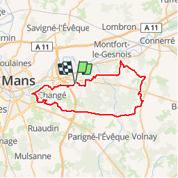
Trail Mountain bike of 50 km to be discovered at Pays de la Loire, Sarthe, Changé. This trail is proposed by tracegps.
Description
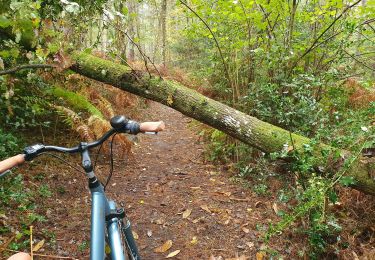
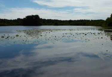
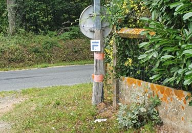
Boucle au départ du Parking du Verger. Passage par quelques chemins militaires, à éviter en cas d'exercice du RIMA. Beau parcours simple et varié, quasiment que sur chemins, dont quelques uns sablonneux (vers Loudon).
Positioning
Country:
France
Region :
Pays de la Loire
Department/Province :
Sarthe
Municipality :
Changé
Location:
Unknown
Start:(Dec)
Start:(UTM)
300849 ; 5319996 (31U) N.
Comments
Trails nearby
![Trail Hybrid bike Parigné-l'Évêque - circuit 11 - Photo](https://media.geolcdn.com/t/375/260/7668b816-8c81-4fe6-b342-bd901e8d9395.jpg&format=jpg&maxdim=2)
![Hybrid bike Hybrid bike](https://static1.geolcdn.com/sitytour/trail-icons/203.png)
circuit 11
Hybrid bike
Easy
Parigné-l'Évêque,
Pays de la Loire,
Sarthe,
France
![](/images/other/stat-length.png)
7.4 km | 8.4 km-effort
36min
![](https://static1.geolcdn.com/siteimages/upload/files/16400158638029165_repeat_loop_refresh_sync_direction_icon.png)
No
![Trail Running Parigné-l'Évêque - Les Commerries - Changé - Photo](https://media.geolcdn.com/t/375/260/ext.jpg?maxdim=2&url=https%3A%2F%2Fservices.sitytrail.com%2FGeolivesWS%2FDownloadMedia.ashx%3FTrailID%3D106741%26Media%3D11405_1.jpg)
![Running Running](https://static1.geolcdn.com/sitytour/trail-icons/103.png)
Les Commerries - Changé
Running
Medium
Parigné-l'Évêque,
Pays de la Loire,
Sarthe,
France
![](/images/other/stat-length.png)
18.6 km | 21 km-effort
1h 45min
![](https://static1.geolcdn.com/siteimages/upload/files/16400158638029165_repeat_loop_refresh_sync_direction_icon.png)
Yes
![Trail sport Changé - 2024-01-20_22h44m29_exp_13-01-24_traces - Photo](https://media.geolcdn.com/t/375/260/ext.jpg?maxdim=2&url=https%3A%2F%2Fsecurestorage.geolives.com%2Fsitytour%2Ftrail-bg%2Fdefault.jpg)
2024-01-20_22h44m29_exp_13-01-24_traces
sport
Very easy
(1)
Changé,
Pays de la Loire,
Sarthe,
France
![](/images/other/stat-length.png)
36 km | 42 km-effort
Unknown
![](https://static1.geolcdn.com/siteimages/upload/files/16400158638029165_repeat_loop_refresh_sync_direction_icon.png)
No
![Trail sport Changé - 2024-01-12_13h36m15_exp_10-01-24_traces - Photo](https://media.geolcdn.com/t/375/260/ext.jpg?maxdim=2&url=https%3A%2F%2Fsecurestorage.geolives.com%2Fsitytour%2Ftrail-bg%2Fdefault.jpg)
2024-01-12_13h36m15_exp_10-01-24_traces
sport
Very easy
Changé,
Pays de la Loire,
Sarthe,
France
![](/images/other/stat-length.png)
36 km | 42 km-effort
Unknown
![](https://static1.geolcdn.com/siteimages/upload/files/16400158638029165_repeat_loop_refresh_sync_direction_icon.png)
Yes
![Trail On foot Changé - Les Commerreries les étangs de Loudon - Photo](https://media.geolcdn.com/t/375/260/ext.jpg?maxdim=2&url=https%3A%2F%2Fstatic1.geolcdn.com%2Fsiteimages%2Fupload%2Ffiles%2F1545311037marcheuse_200dpi.jpg)
![On foot On foot](https://static1.geolcdn.com/sitytour/trail-icons/100.png)
Les Commerreries les étangs de Loudon
On foot
Easy
Changé,
Pays de la Loire,
Sarthe,
France
![](/images/other/stat-length.png)
13.8 km | 15.7 km-effort
3h 33min
![](https://static1.geolcdn.com/siteimages/upload/files/16400158638029165_repeat_loop_refresh_sync_direction_icon.png)
Yes
![Trail Walking Changé - circuit 7 a - Photo](https://media.geolcdn.com/t/375/260/cb63dc41-4be4-4ff0-8a3b-4bfd8ff38ad4.jpg&format=jpg&maxdim=2)
![Walking Walking](https://static1.geolcdn.com/sitytour/trail-icons/101.png)
circuit 7 a
Walking
Medium
Changé,
Pays de la Loire,
Sarthe,
France
![](/images/other/stat-length.png)
6.1 km | 7.3 km-effort
1h 37min
![](https://static1.geolcdn.com/siteimages/upload/files/16400158638029165_repeat_loop_refresh_sync_direction_icon.png)
Yes
![Trail Walking Champagné - L'Huisne . Champagné - Ile aux sports - Photo](https://media.geolcdn.com/t/375/260/ext.jpg?maxdim=2&url=https%3A%2F%2Fstatic1.geolcdn.com%2Fsiteimages%2Fupload%2Ffiles%2F1553511878bg_sport_marche.png)
![Walking Walking](https://static1.geolcdn.com/sitytour/trail-icons/101.png)
L'Huisne . Champagné - Ile aux sports
Walking
Easy
Champagné,
Pays de la Loire,
Sarthe,
France
![](/images/other/stat-length.png)
16.2 km | 17.4 km-effort
3h 53min
![](https://static1.geolcdn.com/siteimages/upload/files/16400158638029165_repeat_loop_refresh_sync_direction_icon.png)
No
![Trail Walking Changé - des Chalottières aux Perdrielles - Photo](https://media.geolcdn.com/t/375/260/ext.jpg?maxdim=2&url=https%3A%2F%2Fstatic1.geolcdn.com%2Fsiteimages%2Fupload%2Ffiles%2F1553511878bg_sport_marche.png)
![Walking Walking](https://static1.geolcdn.com/sitytour/trail-icons/101.png)
des Chalottières aux Perdrielles
Walking
Very easy
Changé,
Pays de la Loire,
Sarthe,
France
![](/images/other/stat-length.png)
4.2 km | 4.8 km-effort
1h 4min
![](https://static1.geolcdn.com/siteimages/upload/files/16400158638029165_repeat_loop_refresh_sync_direction_icon.png)
No
![Trail Walking Changé - De Changé aux Chasseries - Photo](https://media.geolcdn.com/t/375/260/ext.jpg?maxdim=2&url=https%3A%2F%2Fstatic1.geolcdn.com%2Fsiteimages%2Fupload%2Ffiles%2F1553511878bg_sport_marche.png)
![Walking Walking](https://static1.geolcdn.com/sitytour/trail-icons/101.png)
De Changé aux Chasseries
Walking
Very easy
Changé,
Pays de la Loire,
Sarthe,
France
![](/images/other/stat-length.png)
8.9 km | 9.8 km-effort
2h 12min
![](https://static1.geolcdn.com/siteimages/upload/files/16400158638029165_repeat_loop_refresh_sync_direction_icon.png)
No