![](/images/other/stat-length.png)
![Trail Walking Oudon - Les bords de Loire entre Oudon et Ancenis - Photo](https://media.geolcdn.com/t/1900/400/ext.pjpeg?maxdim=2&url=https%3A%2F%2Fservices.sitytrail.com%2FGeolivesWS%2FDownloadMedia.ashx%3FTrailID%3D106913%26Media%3D11674_6.jpg)
Les bords de Loire entre Oudon et Ancenis
tracegps
User
![Length](/images/other/stat-length.png)
Length
22 km
![Max alt](https://static1.geolcdn.com/siteimages/upload/files/1508320355ic_sort_altitude_max_24dp.png)
Max alt
74 m
![Uphill gradient](https://static1.geolcdn.com/siteimages/upload/files/1508320355ic_sort_den_pos_24dp.png)
Uphill gradient
180 m
![Km-Effort](/images/other/stat-length.png)
Km-Effort
24 km
![Min alt](https://static1.geolcdn.com/siteimages/upload/files/1508320355ic_sort_altitude_min_24dp.png)
Min alt
2 m
![Downhill gradient](https://static1.geolcdn.com/siteimages/upload/files/1508320355ic_sort_den_neg_24dp.png)
Downhill gradient
180 m
![Boucle](https://static1.geolcdn.com/siteimages/upload/files/16400158638029165_repeat_loop_refresh_sync_direction_icon.png)
Boucle
Yes
Creation date :
2014-12-10 00:00:00.0
Updated on :
2014-12-10 00:00:00.0
![Walking](https://static1.geolcdn.com/sitytour/trail-icons/101.png)
5h00
Difficulty : Medium
![Scan this QR Code to open this trail in the SityTrail application](https://capi.geolives.com/qq0zvz2zws4bq2lad0pu/sitytour/trails/106913/qr.png?size=200)
FREE GPS app for hiking
About
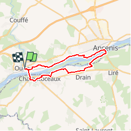
Trail Walking of 22 km to be discovered at Pays de la Loire, Loire-Atlantique, Oudon. This trail is proposed by tracegps.
Description
Au départ d’Oudon, cette boucle longe en premier la rive Nord de la Loire pour la traverser par le pont d’Ancenis. Retour par la rive Sud, avec un détour par Champtoceaux. L’itinéraire retrouve Oudon par le seul pont sur la Loire entre Ancenis et Nantes.
Positioning
Country:
France
Region :
Pays de la Loire
Department/Province :
Loire-Atlantique
Municipality :
Oudon
Location:
Unknown
Start:(Dec)
Start:(UTM)
629582 ; 5245080 (30T) N.
Comments
Trails nearby
![Trail On foot Oudon - PR la vallée du Havre - Photo](https://media.geolcdn.com/t/375/260/33940d66-f465-4229-a313-ac42721d042d.jpeg&format=jpg&maxdim=2)
![On foot On foot](https://static1.geolcdn.com/sitytour/trail-icons/100.png)
PR la vallée du Havre
On foot
Easy
Oudon,
Pays de la Loire,
Loire-Atlantique,
France
![](/images/other/stat-length.png)
6 km | 6.9 km-effort
1h 33min
![](https://static1.geolcdn.com/siteimages/upload/files/16400158638029165_repeat_loop_refresh_sync_direction_icon.png)
Yes
![Trail Walking Orée-d'Anjou - Le prieuré Champtoceaux - Photo](https://media.geolcdn.com/t/375/260/f2f23d66-d208-4d7c-8466-9417f832ff15.jpg&format=jpg&maxdim=2)
![Walking Walking](https://static1.geolcdn.com/sitytour/trail-icons/101.png)
Le prieuré Champtoceaux
Walking
Medium
Orée-d'Anjou,
Pays de la Loire,
Maine-et-Loire,
France
![](/images/other/stat-length.png)
6.3 km | 7.9 km-effort
2h 45min
![](https://static1.geolcdn.com/siteimages/upload/files/16400158638029165_repeat_loop_refresh_sync_direction_icon.png)
Yes
![Trail Walking Orée-d'Anjou - Parcours médiéval - Champtoceaux - Photo](https://media.geolcdn.com/t/375/260/ext.jpg?maxdim=2&url=https%3A%2F%2Fservices.sitytrail.com%2FGeolivesWS%2FDownloadMedia.ashx%3FTrailID%3D112803%26Media%3D12461_6.jpg)
![Walking Walking](https://static1.geolcdn.com/sitytour/trail-icons/101.png)
Parcours médiéval - Champtoceaux
Walking
Easy
Orée-d'Anjou,
Pays de la Loire,
Maine-et-Loire,
France
![](/images/other/stat-length.png)
3.3 km | 4.6 km-effort
1h 0min
![](https://static1.geolcdn.com/siteimages/upload/files/16400158638029165_repeat_loop_refresh_sync_direction_icon.png)
Yes
![Trail Walking Orée-d'Anjou - Champtoceaux - Photo](https://media.geolcdn.com/t/375/260/484b7614-e9d0-4774-b03f-ece84d4b4d13.jpg&format=jpg&maxdim=2)
![Walking Walking](https://static1.geolcdn.com/sitytour/trail-icons/101.png)
Champtoceaux
Walking
Very easy
Orée-d'Anjou,
Pays de la Loire,
Maine-et-Loire,
France
![](/images/other/stat-length.png)
14.2 km | 17.4 km-effort
2h 36min
![](https://static1.geolcdn.com/siteimages/upload/files/16400158638029165_repeat_loop_refresh_sync_direction_icon.png)
Yes
![Trail Walking Le Cellier - Cellier Coulées Clermont - Photo](https://media.geolcdn.com/t/375/260/2361c700-00a0-4a31-87db-f571e08954ff.jpg&format=jpg&maxdim=2)
![Walking Walking](https://static1.geolcdn.com/sitytour/trail-icons/101.png)
Cellier Coulées Clermont
Walking
Medium
Le Cellier,
Pays de la Loire,
Loire-Atlantique,
France
![](/images/other/stat-length.png)
8.4 km | 10.5 km-effort
2h 25min
![](https://static1.geolcdn.com/siteimages/upload/files/16400158638029165_repeat_loop_refresh_sync_direction_icon.png)
Yes
![Trail Walking Le Cellier - Les sillons de Le Cellier -13,5 km - Photo](https://media.geolcdn.com/t/375/260/da3b9a92-d7c5-4831-92ed-9f0b93c284fc.jpg&format=jpg&maxdim=2)
![Walking Walking](https://static1.geolcdn.com/sitytour/trail-icons/101.png)
Les sillons de Le Cellier -13,5 km
Walking
Medium
(1)
Le Cellier,
Pays de la Loire,
Loire-Atlantique,
France
![](/images/other/stat-length.png)
13.5 km | 17 km-effort
6h 55min
![](https://static1.geolcdn.com/siteimages/upload/files/16400158638029165_repeat_loop_refresh_sync_direction_icon.png)
Yes
![Trail Walking Orée-d'Anjou - CHAMPTOCEAUX Parmi les vignes - Photo](https://media.geolcdn.com/t/375/260/1fdca0e0-80dc-4646-943b-b946d1cc0cc9.jpg&format=jpg&maxdim=2)
![Walking Walking](https://static1.geolcdn.com/sitytour/trail-icons/101.png)
CHAMPTOCEAUX Parmi les vignes
Walking
Easy
(1)
Orée-d'Anjou,
Pays de la Loire,
Maine-et-Loire,
France
![](/images/other/stat-length.png)
4.8 km | 6 km-effort
1h 2min
![](https://static1.geolcdn.com/siteimages/upload/files/16400158638029165_repeat_loop_refresh_sync_direction_icon.png)
Yes
![Trail Walking Orée-d'Anjou - Sentier contes et légendes - Champtoceaux - Photo](https://media.geolcdn.com/t/375/260/ext.jpg?maxdim=2&url=https%3A%2F%2Fservices.sitytrail.com%2FGeolivesWS%2FDownloadMedia.ashx%3FTrailID%3D112805%26Media%3D12466_6.jpg)
![Walking Walking](https://static1.geolcdn.com/sitytour/trail-icons/101.png)
Sentier contes et légendes - Champtoceaux
Walking
Medium
(1)
Orée-d'Anjou,
Pays de la Loire,
Maine-et-Loire,
France
![](/images/other/stat-length.png)
3 km | 4 km-effort
1h 0min
![](https://static1.geolcdn.com/siteimages/upload/files/16400158638029165_repeat_loop_refresh_sync_direction_icon.png)
Yes
![Trail Mountain bike Oudon - Oudon - Launay - Mauves - Photo](https://media.geolcdn.com/t/375/260/ext.jpg?maxdim=2&url=https%3A%2F%2Fservices.sitytrail.com%2FGeolivesWS%2FDownloadMedia.ashx%3FTrailID%3D107133%26Media%3D11967_1.jpg)
![Mountain bike Mountain bike](https://static1.geolcdn.com/sitytour/trail-icons/202.png)
Oudon - Launay - Mauves
Mountain bike
Medium
(1)
Oudon,
Pays de la Loire,
Loire-Atlantique,
France
![](/images/other/stat-length.png)
34 km | 39 km-effort
2h 0min
![](https://static1.geolcdn.com/siteimages/upload/files/16400158638029165_repeat_loop_refresh_sync_direction_icon.png)
Yes