![](/images/other/stat-length.png)
![Trail Walking Orlu - Refuge d'En Beys - Les Forges d'Orlu par l'Étang de Naguille - Photo](https://media.geolcdn.com/t/1900/400/ext.pjpeg?maxdim=2&url=https%3A%2F%2Fservices.sitytrail.com%2FGeolivesWS%2FDownloadMedia.ashx%3FTrailID%3D106858%26Media%3D11597_2.jpg)
Refuge d'En Beys - Les Forges d'Orlu par l'Étang de Naguille
tracegps
User
![Length](/images/other/stat-length.png)
![Max alt](https://static1.geolcdn.com/siteimages/upload/files/1508320355ic_sort_altitude_max_24dp.png)
![Uphill gradient](https://static1.geolcdn.com/siteimages/upload/files/1508320355ic_sort_den_pos_24dp.png)
![Km-Effort](/images/other/stat-length.png)
![Min alt](https://static1.geolcdn.com/siteimages/upload/files/1508320355ic_sort_altitude_min_24dp.png)
![Downhill gradient](https://static1.geolcdn.com/siteimages/upload/files/1508320355ic_sort_den_neg_24dp.png)
![Boucle](https://static1.geolcdn.com/siteimages/upload/files/16400158638029165_repeat_loop_refresh_sync_direction_icon.png)
![Walking](https://static1.geolcdn.com/sitytour/trail-icons/101.png)
6h00
Difficulty : Difficult
![Scan this QR Code to open this trail in the SityTrail application](https://capi.geolives.com/qq0zvz2zws4bq2lad0pu/sitytour/trails/106858/qr.png?size=200)
FREE GPS app for hiking
About
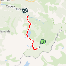
Trail Walking of 12.2 km to be discovered at Occitania, Ariège, Orlu. This trail is proposed by tracegps.
Description
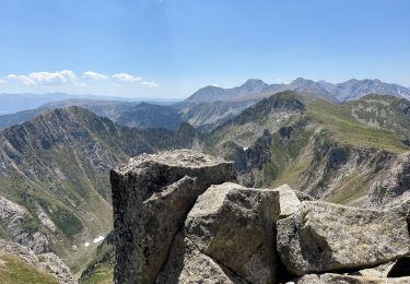
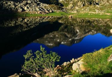
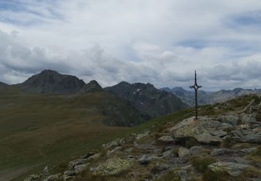
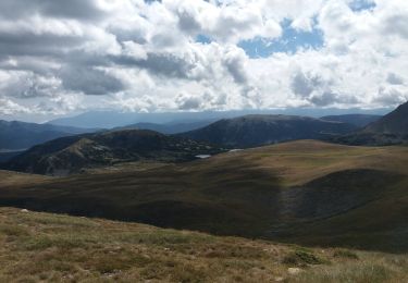
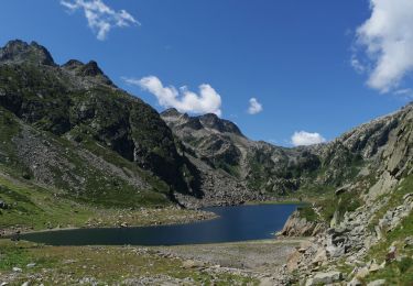
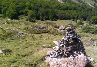
Jour 2 : Refuge d’En Beys – Les Forges d’Orlu par l’Étang de Naguille Durée : 6 heures - Dénivelé : 410 m - Dénivelé - : 1450 m - Type : Aller simple On quitte le refuge en longeant l’étang d’En Beys. Arrivé au bout de l’étang, on laisse le GR 7 et l’on suit le balisage rouge et jaune en direction de la Couillade d’En Beys. Le sentier chemine dans le cirque du fond du lac en passant prés de plusieurs petits étangs avant de monter en direction de l’ouest. La montée est raide mais le panorama s’élargit de plus en plus. On arrive a un premier cirque puis un petit collet qui nous fait croire que l’on est arrivé mais il reste encore une petit montée avant d’arriver au vrai col, la fameuse Couillade d’En Beys. En fait, le sentier passe au pied de l’éperon sud du pic d’En Beys au dessus du col. Là, le panorama s’ouvre sur le cirque des Peyrisses et l’on voit l’étang d’En beys derrière nous qui semble maintenant bien loin. On attaque la descente, il ne faut pas la sous-estimée. Elle n’est jamais très difficile mais elle est assez longue… Le sentier descend d’abord par quelques lacets puis par une traversé vers le lac de Naguilhes. Le chemin descend progressivement pour arriver à la cabane d’Echouzé. On longe ensuite par la rive gauche le grand lac de Naguilhe. Puis la descente s’accentue sous le barrage de Naguilhe pour descendre dans un premier temps dans une végétation luxuriante puis dans une belle forêt de hètres jusqu’au parking de forges d’Orlu.
Positioning
Comments
Trails nearby
![Trail Walking Orlu - Vers le roc Blanc en partant du Fanguil puis les étangs de Baxouillade - Photo](https://media.geolcdn.com/t/375/260/039269ed-b0a9-4cb7-bbae-7a407c762425.jpg&format=jpg&maxdim=2)
![Walking Walking](https://static1.geolcdn.com/sitytour/trail-icons/101.png)
Walking
![](/images/other/stat-length.png)
![](https://static1.geolcdn.com/siteimages/upload/files/16400158638029165_repeat_loop_refresh_sync_direction_icon.png)
![Trail On foot Orlu - Refuge d'En Beys - Photo](https://media.geolcdn.com/t/375/260/eb4055f1-5854-462c-936a-b50aa5d52ddf.jpeg&format=jpg&maxdim=2)
![On foot On foot](https://static1.geolcdn.com/sitytour/trail-icons/100.png)
![Trail Walking Orlu - en beys vers camporels - Photo](https://media.geolcdn.com/t/375/260/5527ab00-d4a9-417d-b5a3-5c57b605d5ec.jpg&format=jpg&maxdim=2)
![Walking Walking](https://static1.geolcdn.com/sitytour/trail-icons/101.png)
Walking
![](/images/other/stat-length.png)
![](https://static1.geolcdn.com/siteimages/upload/files/16400158638029165_repeat_loop_refresh_sync_direction_icon.png)
![Trail Walking Orlu - E10-GR10-2024 - Photo](https://media.geolcdn.com/t/375/260/b940d744-b2da-4320-a0eb-223ababa594e.jpg&format=jpg&maxdim=2)
![Walking Walking](https://static1.geolcdn.com/sitytour/trail-icons/101.png)
Walking
![](/images/other/stat-length.png)
![](https://static1.geolcdn.com/siteimages/upload/files/16400158638029165_repeat_loop_refresh_sync_direction_icon.png)
![Trail Walking Orlu - Fanguil refuge d en eys - Photo](https://media.geolcdn.com/t/375/260/4fb84d32-67be-493a-a44d-75021283488e.jpg&format=jpg&maxdim=2)
![Walking Walking](https://static1.geolcdn.com/sitytour/trail-icons/101.png)
Walking
![](/images/other/stat-length.png)
![](https://static1.geolcdn.com/siteimages/upload/files/16400158638029165_repeat_loop_refresh_sync_direction_icon.png)
![Trail Walking Orlu - Ariège 4 - Photo](https://media.geolcdn.com/t/375/260/ext.jpg?maxdim=2&url=https%3A%2F%2Fservices.sitytrail.com%2FGeolivesWS%2FDownloadMedia.ashx%3FTrailID%3D817725%26Media%3Dfix__20170814142905.jpg)
![Walking Walking](https://static1.geolcdn.com/sitytour/trail-icons/101.png)
![Trail Walking Orlu - GR7 E36 RefugeDeBeys-FontRomeu - Photo](https://media.geolcdn.com/t/375/260/ext.jpg?maxdim=2&url=https%3A%2F%2Fstatic1.geolcdn.com%2Fsiteimages%2Fupload%2Ffiles%2F1553511878bg_sport_marche.png)
![Walking Walking](https://static1.geolcdn.com/sitytour/trail-icons/101.png)
Walking
![](/images/other/stat-length.png)
![](https://static1.geolcdn.com/siteimages/upload/files/16400158638029165_repeat_loop_refresh_sync_direction_icon.png)
![Trail Other activity Orlu - 2013 08 - J2 - OK - variante cometa - Photo](https://media.geolcdn.com/t/375/260/ext.jpg?maxdim=2&url=https%3A%2F%2Fstatic1.geolcdn.com%2Fsiteimages%2Fupload%2Ffiles%2F1545311037marcheuse_200dpi.jpg)
![Other activity Other activity](https://static1.geolcdn.com/sitytour/trail-icons/900.png)
Other activity
![](/images/other/stat-length.png)
![](https://static1.geolcdn.com/siteimages/upload/files/16400158638029165_repeat_loop_refresh_sync_direction_icon.png)
![Trail Walking Angoustrine-Villeneuve-des-Escaldes - GR 10 28 - Photo](https://media.geolcdn.com/t/375/260/ext.jpg?maxdim=2&url=https%3A%2F%2Fstatic1.geolcdn.com%2Fsiteimages%2Fupload%2Ffiles%2F1553511878bg_sport_marche.png)
![Walking Walking](https://static1.geolcdn.com/sitytour/trail-icons/101.png)
Walking
![](/images/other/stat-length.png)
![](https://static1.geolcdn.com/siteimages/upload/files/16400158638029165_repeat_loop_refresh_sync_direction_icon.png)