![](/images/other/stat-length.png)
![Trail Running Yvré-l'Évêque - Bois de Changé - Le Mans - Photo](https://media.geolcdn.com/t/1900/400/ext.pjpeg?maxdim=2&url=https%3A%2F%2Fservices.sitytrail.com%2FGeolivesWS%2FDownloadMedia.ashx%3FTrailID%3D106773%26Media%3D11453_1.jpg)
Bois de Changé - Le Mans
tracegps
User
![Length](/images/other/stat-length.png)
Length
16.4 km
![Max alt](https://static1.geolcdn.com/siteimages/upload/files/1508320355ic_sort_altitude_max_24dp.png)
Max alt
97 m
![Uphill gradient](https://static1.geolcdn.com/siteimages/upload/files/1508320355ic_sort_den_pos_24dp.png)
Uphill gradient
197 m
![Km-Effort](/images/other/stat-length.png)
Km-Effort
19.1 km
![Min alt](https://static1.geolcdn.com/siteimages/upload/files/1508320355ic_sort_altitude_min_24dp.png)
Min alt
46 m
![Downhill gradient](https://static1.geolcdn.com/siteimages/upload/files/1508320355ic_sort_den_neg_24dp.png)
Downhill gradient
194 m
![Boucle](https://static1.geolcdn.com/siteimages/upload/files/16400158638029165_repeat_loop_refresh_sync_direction_icon.png)
Boucle
Yes
Creation date :
2014-12-10 00:00:00.0
Updated on :
2014-12-10 00:00:00.0
![Running](https://static1.geolcdn.com/sitytour/trail-icons/103.png)
1h30
Difficulty : Medium
![Scan this QR Code to open this trail in the SityTrail application](https://capi.geolives.com/qq0zvz2zws4bq2lad0pu/sitytour/trails/106773/qr.png?size=200)
FREE GPS app for hiking
About
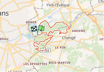
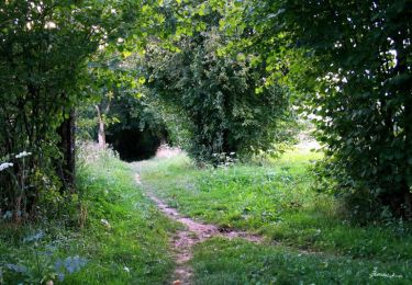
Trail Running of 16.4 km to be discovered at Pays de la Loire, Sarthe, Yvré-l'Évêque. This trail is proposed by tracegps.
Description
Très beau parcours dans les Bois de Changé à la porte du Mans. Circuit relativement facile (dénivelé 248 mètres). A faire également à vtt en famille.
Positioning
Country:
France
Region :
Pays de la Loire
Department/Province :
Sarthe
Municipality :
Yvré-l'Évêque
Location:
Unknown
Start:(Dec)
Start:(UTM)
294579 ; 5318848 (31T) N.
Comments
Trails nearby
![Trail Mountain bike Changé - Boucle Le Mans - Changé - Brettes - Parigné - Challes 53 km - Photo](https://media.geolcdn.com/t/375/260/ext.jpg?maxdim=2&url=https%3A%2F%2Fservices.sitytrail.com%2FGeolivesWS%2FDownloadMedia.ashx%3FTrailID%3D172382%26Media%3D13727_1.jpg)
![Mountain bike Mountain bike](https://static1.geolcdn.com/sitytour/trail-icons/202.png)
Boucle Le Mans - Changé - Brettes - Parigné - Challes 53 km
Mountain bike
Medium
(2)
Changé,
Pays de la Loire,
Sarthe,
France
![](/images/other/stat-length.png)
53 km | 60 km-effort
2h 30min
![](https://static1.geolcdn.com/siteimages/upload/files/16400158638029165_repeat_loop_refresh_sync_direction_icon.png)
No
![Trail Walking Le Mans - Le Mans, randonnée autour et dans la ville - Photo](https://media.geolcdn.com/t/375/260/bec9cef1-0536-4c4e-939a-116e56206659.jpg&format=jpg&maxdim=2)
![Walking Walking](https://static1.geolcdn.com/sitytour/trail-icons/101.png)
Le Mans, randonnée autour et dans la ville
Walking
Easy
Le Mans,
Pays de la Loire,
Sarthe,
France
![](/images/other/stat-length.png)
23 km | 26 km-effort
10h 57min
![](https://static1.geolcdn.com/siteimages/upload/files/16400158638029165_repeat_loop_refresh_sync_direction_icon.png)
Yes
![Trail Walking Le Mans - Arche de la nature - Photo](https://media.geolcdn.com/t/375/260/e44f39e5-6695-45d2-ba25-89283625b186.jpg&format=jpg&maxdim=2)
![Walking Walking](https://static1.geolcdn.com/sitytour/trail-icons/101.png)
Arche de la nature
Walking
Easy
Le Mans,
Pays de la Loire,
Sarthe,
France
![](/images/other/stat-length.png)
5.4 km | 6 km-effort
45min
![](https://static1.geolcdn.com/siteimages/upload/files/16400158638029165_repeat_loop_refresh_sync_direction_icon.png)
Yes
![Trail Walking Yvré-l'Évêque - le Verger - Photo](https://media.geolcdn.com/t/375/260/cdfe34b7-2572-469d-9b3e-3434cbe674e1.jpg&format=jpg&maxdim=2)
![Walking Walking](https://static1.geolcdn.com/sitytour/trail-icons/101.png)
le Verger
Walking
Very easy
Yvré-l'Évêque,
Pays de la Loire,
Sarthe,
France
![](/images/other/stat-length.png)
8 km | 9.4 km-effort
2h 18min
![](https://static1.geolcdn.com/siteimages/upload/files/16400158638029165_repeat_loop_refresh_sync_direction_icon.png)
Yes
![Trail Mountain bike Coulaines - 34 km coulaines - Photo](https://media.geolcdn.com/t/375/260/ext.jpg?maxdim=2&url=https%3A%2F%2Fstatic1.geolcdn.com%2Fsiteimages%2Fupload%2Ffiles%2F1524743154velo.jpg)
![Mountain bike Mountain bike](https://static1.geolcdn.com/sitytour/trail-icons/202.png)
34 km coulaines
Mountain bike
Medium
(1)
Coulaines,
Pays de la Loire,
Sarthe,
France
![](/images/other/stat-length.png)
34 km | 40 km-effort
Unknown
![](https://static1.geolcdn.com/siteimages/upload/files/16400158638029165_repeat_loop_refresh_sync_direction_icon.png)
Yes
![Trail Walking Coulaines - Ville et Nature - Coulaines - Photo](https://media.geolcdn.com/t/375/260/ext.jpg?maxdim=2&url=https%3A%2F%2Fservices.sitytrail.com%2FGeolivesWS%2FDownloadMedia.ashx%3FTrailID%3D173074%26Media%3D14606_6.jpg)
![Walking Walking](https://static1.geolcdn.com/sitytour/trail-icons/101.png)
Ville et Nature - Coulaines
Walking
Medium
Coulaines,
Pays de la Loire,
Sarthe,
France
![](/images/other/stat-length.png)
10.2 km | 11.9 km-effort
2h 30min
![](https://static1.geolcdn.com/siteimages/upload/files/16400158638029165_repeat_loop_refresh_sync_direction_icon.png)
Yes
![Trail Walking Sargé-lès-le-Mans - sarge - Photo](https://media.geolcdn.com/t/375/260/934cfce8-a7b9-445c-9139-42fc8672e442.jpg&format=jpg&maxdim=2)
![Walking Walking](https://static1.geolcdn.com/sitytour/trail-icons/101.png)
sarge
Walking
Medium
Sargé-lès-le-Mans,
Pays de la Loire,
Sarthe,
France
![](/images/other/stat-length.png)
5.7 km | 6.6 km-effort
1h 43min
![](https://static1.geolcdn.com/siteimages/upload/files/16400158638029165_repeat_loop_refresh_sync_direction_icon.png)
Yes
![Trail Mountain bike Yvré-l'Évêque - Boucle Le Mans - Etangs Loudon - Challes - Grammont - Brettes - Ruaudin - 65 km - Photo](https://media.geolcdn.com/t/375/260/ext.jpg?maxdim=2&url=https%3A%2F%2Fservices.sitytrail.com%2FGeolivesWS%2FDownloadMedia.ashx%3FTrailID%3D172383%26Media%3D13729_1.jpg)
![Mountain bike Mountain bike](https://static1.geolcdn.com/sitytour/trail-icons/202.png)
Boucle Le Mans - Etangs Loudon - Challes - Grammont - Brettes - Ruaudin - 65 km
Mountain bike
Difficult
Yvré-l'Évêque,
Pays de la Loire,
Sarthe,
France
![](/images/other/stat-length.png)
64 km | 74 km-effort
3h 30min
![](https://static1.geolcdn.com/siteimages/upload/files/16400158638029165_repeat_loop_refresh_sync_direction_icon.png)
Yes
![Trail Walking Le Mans - abbaye del epau - Photo](https://media.geolcdn.com/t/375/260/ext.jpg?maxdim=2&url=https%3A%2F%2Fstatic1.geolcdn.com%2Fsiteimages%2Fupload%2Ffiles%2F1553511878bg_sport_marche.png)
![Walking Walking](https://static1.geolcdn.com/sitytour/trail-icons/101.png)
abbaye del epau
Walking
Easy
Le Mans,
Pays de la Loire,
Sarthe,
France
![](/images/other/stat-length.png)
3.5 km | 3.7 km-effort
1h 44min
![](https://static1.geolcdn.com/siteimages/upload/files/16400158638029165_repeat_loop_refresh_sync_direction_icon.png)
Yes