![](/images/other/stat-length.png)
![Trail Mountain bike Égliseneuve-d'Entraigues - Espace VTT FFC du Sancy - Circuit n°13 - La Chaux - Secteur Egliseneuve d'Entraigues - Photo](https://media.geolcdn.com/t/1900/400/ext.pjpeg?maxdim=2&url=https%3A%2F%2Fservices.sitytrail.com%2FGeolivesWS%2FDownloadMedia.ashx%3FTrailID%3D106757%26Media%3D11424_2.jpg)
Espace VTT FFC du Sancy - Circuit n°13 - La Chaux - Secteur Egliseneuve d'Entraigues
tracegps
User
![Length](/images/other/stat-length.png)
![Max alt](https://static1.geolcdn.com/siteimages/upload/files/1508320355ic_sort_altitude_max_24dp.png)
![Uphill gradient](https://static1.geolcdn.com/siteimages/upload/files/1508320355ic_sort_den_pos_24dp.png)
![Km-Effort](/images/other/stat-length.png)
![Min alt](https://static1.geolcdn.com/siteimages/upload/files/1508320355ic_sort_altitude_min_24dp.png)
![Downhill gradient](https://static1.geolcdn.com/siteimages/upload/files/1508320355ic_sort_den_neg_24dp.png)
![Boucle](https://static1.geolcdn.com/siteimages/upload/files/16400158638029165_repeat_loop_refresh_sync_direction_icon.png)
![Mountain bike](https://static1.geolcdn.com/sitytour/trail-icons/202.png)
1h19
Difficulty : Difficult
![Scan this QR Code to open this trail in the SityTrail application](https://capi.geolives.com/qq0zvz2zws4bq2lad0pu/sitytour/trails/106757/qr.png?size=200)
FREE GPS app for hiking
About
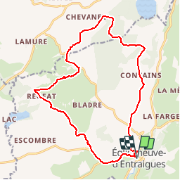
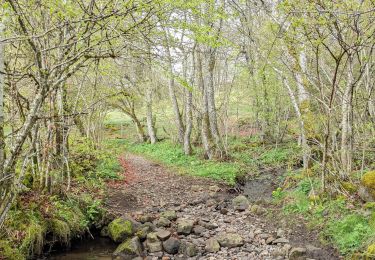
Trail Mountain bike of 18.7 km to be discovered at Auvergne-Rhône-Alpes, Puy-de-Dôme, Égliseneuve-d'Entraigues. This trail is proposed by tracegps.
Description
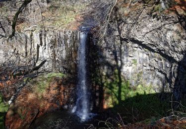
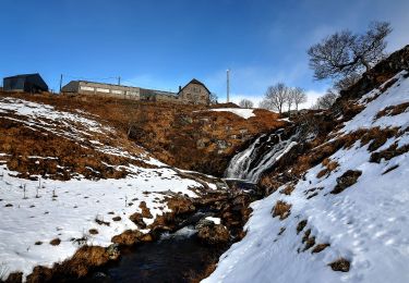
Espace VTT FFC du Sancy - Circuit n°13 - La Chaux - Secteur Egliseneuve d'Entraigues Circuit officiel labellisé par la Fédération Française de Cyclisme. Départ au Gîte d’étape des Rivaux. Un itinéraire accidenté pour sportifs, au pays « d’entre les eaux » et en bordure nord du plateau du Cézallier.
Positioning
Comments
Trails nearby
![Trail On foot Égliseneuve-d'Entraigues - Aulnay - Photo](https://media.geolcdn.com/t/375/260/b29b9335-03fb-40ee-b496-851e91bece85.jpeg&format=jpg&maxdim=2)
![On foot On foot](https://static1.geolcdn.com/sitytour/trail-icons/100.png)
On foot
![](/images/other/stat-length.png)
![](https://static1.geolcdn.com/siteimages/upload/files/16400158638029165_repeat_loop_refresh_sync_direction_icon.png)
![Trail On foot Égliseneuve-d'Entraigues - La visade - Photo](https://media.geolcdn.com/t/375/260/b29b9335-03fb-40ee-b496-851e91bece85.jpeg&format=jpg&maxdim=2)
![On foot On foot](https://static1.geolcdn.com/sitytour/trail-icons/100.png)
On foot
![](/images/other/stat-length.png)
![](https://static1.geolcdn.com/siteimages/upload/files/16400158638029165_repeat_loop_refresh_sync_direction_icon.png)
![Trail On foot Espinchal - Le Bois de Play - Photo](https://media.geolcdn.com/t/375/260/9599b8e6-5ea9-47d4-b175-142e2bc24cd5.jpeg&format=jpg&maxdim=2)
![On foot On foot](https://static1.geolcdn.com/sitytour/trail-icons/100.png)
On foot
![](/images/other/stat-length.png)
![](https://static1.geolcdn.com/siteimages/upload/files/16400158638029165_repeat_loop_refresh_sync_direction_icon.png)
![Trail On foot Égliseneuve-d'Entraigues - La cime des pres - Photo](https://media.geolcdn.com/t/375/260/2f1290cf-e7a6-4663-8ec6-3697089cc854.jpeg&format=jpg&maxdim=2)
![On foot On foot](https://static1.geolcdn.com/sitytour/trail-icons/100.png)
On foot
![](/images/other/stat-length.png)
![](https://static1.geolcdn.com/siteimages/upload/files/16400158638029165_repeat_loop_refresh_sync_direction_icon.png)
![Trail On foot Égliseneuve-d'Entraigues - Bogon - Photo](https://media.geolcdn.com/t/375/260/9cd056e6-e5cc-4cac-ae56-b755de736eab.jpeg&format=jpg&maxdim=2)
![On foot On foot](https://static1.geolcdn.com/sitytour/trail-icons/100.png)
On foot
![](/images/other/stat-length.png)
![](https://static1.geolcdn.com/siteimages/upload/files/16400158638029165_repeat_loop_refresh_sync_direction_icon.png)
![Trail On foot Égliseneuve-d'Entraigues - Auger - Photo](https://media.geolcdn.com/t/375/260/9cd056e6-e5cc-4cac-ae56-b755de736eab.jpeg&format=jpg&maxdim=2)
![On foot On foot](https://static1.geolcdn.com/sitytour/trail-icons/100.png)
On foot
![](/images/other/stat-length.png)
![](https://static1.geolcdn.com/siteimages/upload/files/16400158638029165_repeat_loop_refresh_sync_direction_icon.png)
![Trail On foot Picherande - Le Lac Chauvet - Photo](https://media.geolcdn.com/t/375/260/0a06c9c2-0789-44b7-b2be-bed9042bb6fe.jpeg&format=jpg&maxdim=2)
![On foot On foot](https://static1.geolcdn.com/sitytour/trail-icons/100.png)
On foot
![](/images/other/stat-length.png)
![](https://static1.geolcdn.com/siteimages/upload/files/16400158638029165_repeat_loop_refresh_sync_direction_icon.png)
![Trail Walking Égliseneuve-d'Entraigues - Boucle Egliseneuve d’Entraigue - les cascades - Photo](https://media.geolcdn.com/t/375/260/13e9c10c-5370-47e0-843e-54694937f120.jpg&format=jpg&maxdim=2)
![Walking Walking](https://static1.geolcdn.com/sitytour/trail-icons/101.png)
Walking
![](/images/other/stat-length.png)
![](https://static1.geolcdn.com/siteimages/upload/files/16400158638029165_repeat_loop_refresh_sync_direction_icon.png)
![Trail Walking Égliseneuve-d'Entraigues - boucle 10 km autour du lac chauvet - Photo](https://media.geolcdn.com/t/375/260/f66868cc-89e4-4308-8405-667a78fa145a.jpg&format=jpg&maxdim=2)
![Walking Walking](https://static1.geolcdn.com/sitytour/trail-icons/101.png)
Walking
![](/images/other/stat-length.png)
![](https://static1.geolcdn.com/siteimages/upload/files/16400158638029165_repeat_loop_refresh_sync_direction_icon.png)