![](/images/other/stat-length.png)
![Trail Walking Montirat - Lagarde Viaur 16km - Photo](https://media.geolcdn.com/t/1900/400/ext.pjpeg?maxdim=2&url=https%3A%2F%2Fstatic1.geolcdn.com%2Fsiteimages%2Fupload%2Ffiles%2F1553511878bg_sport_marche.png)
Lagarde Viaur 16km
YV24
User
![Length](/images/other/stat-length.png)
Length
15.2 km
![Max alt](https://static1.geolcdn.com/siteimages/upload/files/1508320355ic_sort_altitude_max_24dp.png)
Max alt
438 m
![Uphill gradient](https://static1.geolcdn.com/siteimages/upload/files/1508320355ic_sort_den_pos_24dp.png)
Uphill gradient
494 m
![Km-Effort](/images/other/stat-length.png)
Km-Effort
22 km
![Min alt](https://static1.geolcdn.com/siteimages/upload/files/1508320355ic_sort_altitude_min_24dp.png)
Min alt
171 m
![Downhill gradient](https://static1.geolcdn.com/siteimages/upload/files/1508320355ic_sort_den_neg_24dp.png)
Downhill gradient
493 m
![Boucle](https://static1.geolcdn.com/siteimages/upload/files/16400158638029165_repeat_loop_refresh_sync_direction_icon.png)
Boucle
Yes
Creation date :
2019-01-15 18:28:01.697
Updated on :
2019-01-15 18:28:01.697
![Walking](https://static1.geolcdn.com/sitytour/trail-icons/101.png)
4h38
Difficulty : Easy
![Scan this QR Code to open this trail in the SityTrail application](https://capi.geolives.com/qq0zvz2zws4bq2lad0pu/sitytour/trails/1067150/qr.png?size=200)
FREE GPS app for hiking
About
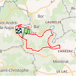
Trail Walking of 15.2 km to be discovered at Occitania, Tarn, Montirat. This trail is proposed by YV24.
Description
Circuit varié,diversement balisé, ou pas du tout.Parking limité =au départ du village. Petit raidillon en descente vers la Brègue, qqs marches de rondins non entretenues. Pique-nique possible en bordure du Viaur, au pont de la Vicasse.
Positioning
Country:
France
Region :
Occitania
Department/Province :
Tarn
Municipality :
Montirat
Location:
Unknown
Start:(Dec)
Start:(UTM)
424843 ; 4892178 (31T) N.
Comments
Trails nearby
![Trail Walking Bor-et-Bar - Bor et Bar - Photo](https://media.geolcdn.com/t/375/260/ext.jpg?maxdim=2&url=https%3A%2F%2Fstatic1.geolcdn.com%2Fsiteimages%2Fupload%2Ffiles%2F1553511878bg_sport_marche.png)
![Walking Walking](https://static1.geolcdn.com/sitytour/trail-icons/101.png)
Bor et Bar
Walking
Difficult
Bor-et-Bar,
Occitania,
Aveyron,
France
![](/images/other/stat-length.png)
13 km | 16.9 km-effort
3h 50min
![](https://static1.geolcdn.com/siteimages/upload/files/16400158638029165_repeat_loop_refresh_sync_direction_icon.png)
Yes
![Trail Walking Montirat - 2024-05-21_19h40m27_visorando-la-vallee-de-lagarde-viaur - Photo](https://media.geolcdn.com/t/375/260/ext.jpg?maxdim=2&url=https%3A%2F%2Fstatic1.geolcdn.com%2Fsiteimages%2Fupload%2Ffiles%2F1553511878bg_sport_marche.png)
![Walking Walking](https://static1.geolcdn.com/sitytour/trail-icons/101.png)
2024-05-21_19h40m27_visorando-la-vallee-de-lagarde-viaur
Walking
Difficult
Montirat,
Occitania,
Tarn,
France
![](/images/other/stat-length.png)
12.5 km | 17.6 km-effort
4h 0min
![](https://static1.geolcdn.com/siteimages/upload/files/16400158638029165_repeat_loop_refresh_sync_direction_icon.png)
Yes
![Trail Walking Montirat - Lagarde viaur - Photo](https://media.geolcdn.com/t/375/260/ext.jpg?maxdim=2&url=https%3A%2F%2Fstatic1.geolcdn.com%2Fsiteimages%2Fupload%2Ffiles%2F1553511878bg_sport_marche.png)
![Walking Walking](https://static1.geolcdn.com/sitytour/trail-icons/101.png)
![Trail Mountain bike Saint-André-de-Najac - Projet rando jour 3 - Photo](https://media.geolcdn.com/t/375/260/ext.jpg?maxdim=2&url=https%3A%2F%2Fstatic1.geolcdn.com%2Fsiteimages%2Fupload%2Ffiles%2F1524743154velo.jpg)
![Mountain bike Mountain bike](https://static1.geolcdn.com/sitytour/trail-icons/202.png)
Projet rando jour 3
Mountain bike
Medium
Saint-André-de-Najac,
Occitania,
Aveyron,
France
![](/images/other/stat-length.png)
16.1 km | 22 km-effort
1h 30min
![](https://static1.geolcdn.com/siteimages/upload/files/16400158638029165_repeat_loop_refresh_sync_direction_icon.png)
Yes
![Trail On foot Montirat - randogps81-378 - Photo](https://media.geolcdn.com/t/375/260/ext.jpg?maxdim=2&url=https%3A%2F%2Fstatic1.geolcdn.com%2Fsiteimages%2Fupload%2Ffiles%2F1545311037marcheuse_200dpi.jpg)
![On foot On foot](https://static1.geolcdn.com/sitytour/trail-icons/100.png)
![Trail Walking Bor-et-Bar - Gourpassou vers Maraval - Photo](https://media.geolcdn.com/t/375/260/ext.jpg?maxdim=2&url=https%3A%2F%2Fstatic1.geolcdn.com%2Fsiteimages%2Fupload%2Ffiles%2F1553511878bg_sport_marche.png)
![Walking Walking](https://static1.geolcdn.com/sitytour/trail-icons/101.png)
Gourpassou vers Maraval
Walking
Medium
Bor-et-Bar,
Occitania,
Aveyron,
France
![](/images/other/stat-length.png)
9.2 km | 13.2 km-effort
3h 0min
![](https://static1.geolcdn.com/siteimages/upload/files/16400158638029165_repeat_loop_refresh_sync_direction_icon.png)
Yes
![Trail Mountain bike La Fouillade - VTT Toulzanes 03072022 - Photo](https://media.geolcdn.com/t/375/260/ext.jpg?maxdim=2&url=https%3A%2F%2Fstatic1.geolcdn.com%2Fsiteimages%2Fupload%2Ffiles%2F1524743154velo.jpg)
![Mountain bike Mountain bike](https://static1.geolcdn.com/sitytour/trail-icons/202.png)
VTT Toulzanes 03072022
Mountain bike
Easy
La Fouillade,
Occitania,
Aveyron,
France
![](/images/other/stat-length.png)
13.4 km | 16.8 km-effort
2h 17min
![](https://static1.geolcdn.com/siteimages/upload/files/16400158638029165_repeat_loop_refresh_sync_direction_icon.png)
Yes
![Trail Walking Bor-et-Bar - Lasbinals Bor - Photo](https://media.geolcdn.com/t/375/260/ext.jpg?maxdim=2&url=https%3A%2F%2Fstatic1.geolcdn.com%2Fsiteimages%2Fupload%2Ffiles%2F1553511878bg_sport_marche.png)
![Walking Walking](https://static1.geolcdn.com/sitytour/trail-icons/101.png)
Lasbinals Bor
Walking
Easy
Bor-et-Bar,
Occitania,
Aveyron,
France
![](/images/other/stat-length.png)
8.5 km | 11.8 km-effort
2h 36min
![](https://static1.geolcdn.com/siteimages/upload/files/16400158638029165_repeat_loop_refresh_sync_direction_icon.png)
Yes
![Trail Walking Jouqueviel - INFOURNATS 2021.07.03 - Photo](https://media.geolcdn.com/t/375/260/ext.jpg?maxdim=2&url=https%3A%2F%2Fstatic1.geolcdn.com%2Fsiteimages%2Fupload%2Ffiles%2F1553511878bg_sport_marche.png)
![Walking Walking](https://static1.geolcdn.com/sitytour/trail-icons/101.png)
INFOURNATS 2021.07.03
Walking
Difficult
Jouqueviel,
Occitania,
Tarn,
France
![](/images/other/stat-length.png)
3.9 km | 6.1 km-effort
2h 9min
![](https://static1.geolcdn.com/siteimages/upload/files/16400158638029165_repeat_loop_refresh_sync_direction_icon.png)
Yes