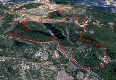
Trail Cycle Ginasservis - Ginasservis et les Lacs du Verdon - Photo

Ginasservis et les Lacs du Verdon

 tracegps
tracegps

User

© OpenStreetMap contributors
Length
Length
140 km
Max alt
Max alt
652 m
Uphill gradient
Uphill gradient
2378 m
Km-Effort
Km-Effort  
171 km
Min alt
Min alt
305 m
Downhill gradient
Downhill gradient
2379 m
Boucle
Boucle
Yes
Creation date :
2014-12-10 00:00:00.0
Updated on :
2014-12-10 00:00:00.0

(0 Reviews)

Cycle
Cycle
5h49
Difficulty : Difficult

Scan this QR Code to open this trail in the SityTrail application

FREE GPS app for hiking

Logo SityTrail SityTrail

IGN / Geographical institutes

Download SityTrail from the App Store Download SityTrail from Google Play

Logo SityTrail SityTrail World

The world is yours!

Download SityTrail from the App Store Download SityTrail from Google Play Download SityTrail on Huawei AppGallery

About

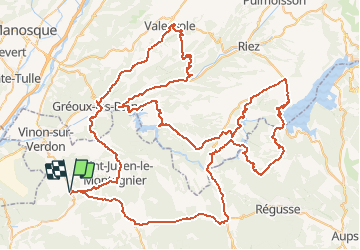
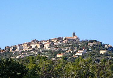
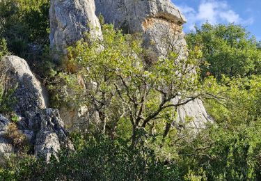
Trail Cycle of 140 km to be discovered at Provence-Alpes-Côte d'Azur, Var, Ginasservis. This trail is proposed by tracegps.

Description

Très beau circuit qui passe au milieu des champs de lavande, superbes vues sur différents lacs du Verdon. Pas de côtes très difficiles mais répétitives, sur la fin j'ai eu beaucoup de vent, il faut une bonne condition physique pour effectuer ce parcours.

Elevation profile

Positioning

Country:
France
Region :
Provence-Alpes-Côte d'Azur
Department/Province :
Var
Municipality :
Ginasservis
Location:
Unknown
Start:(UTM)
729489 ; 4839489 (31T) N.

Trails nearby

Trail Walking Saint-Julien - St Julien - Grotte de Malavasse  - Photo
Walking
GUIDE
fredetpascale

Walking

Medium
(1)
Saint-Julien, Provence-Alpes-Côte d'Azur, Var, France
10.8 km | 15 km-effort
3h 45min
Yes
Trail Walking Saint-Julien - Le drapeau depuis Les Hugous+ petite incursion dans Malavalas - Photo
Walking
Migueldefrance

Walking

Medium
(1)
Saint-Julien, Provence-Alpes-Côte d'Azur, Var, France
3.8 km | 5.4 km-effort
1h 52min
Yes
Trail Walking Saint-Julien - St Jean le Montagnier - Photo
Walking
Loumo29

Walking

Medium
Saint-Julien, Provence-Alpes-Côte d'Azur, Var, France
13.8 km | 18.1 km-effort
3h 52min
Yes
Trail Walking Saint-Julien - Traversée des gorges de Malavalasse  - Photo
Walking
Migueldefrance

Walking

Easy
Saint-Julien, Provence-Alpes-Côte d'Azur, Var, France
4.1 km | 5.7 km-effort
1h 17min
Yes
Trail Walking Saint-Julien - CduL - Photo
Walking
Andre Vicente

Walking

Medium
Saint-Julien, Provence-Alpes-Côte d'Azur, Var, France
6 km | 8 km-effort
2h 12min
No
Trail Walking Saint-Julien - rando st julien 22 sept 22 - Photo
Walking
cocojean

Walking

Difficult
Saint-Julien, Provence-Alpes-Côte d'Azur, Var, France
12.6 km | 17.3 km-effort
3h 43min
Yes
Trail Other activity Saint-Julien - boisset - Photo
Other activity
jo-ba

Other activity

Easy
Saint-Julien, Provence-Alpes-Côte d'Azur, Var, France
16.3 km | 21 km-effort
6h 34min
Yes
Trail Walking Ginasservis - Mont Major - Photo
Walking
Loumo29

Walking

Easy
Ginasservis, Provence-Alpes-Côte d'Azur, Var, France
9.2 km | 13 km-effort
2h 45min
Yes
Trail Walking Vinon-sur-Verdon - Vinon - Photo
Walking
martinemarie

Walking

Medium
Vinon-sur-Verdon, Provence-Alpes-Côte d'Azur, Var, France
5.9 km | 7.3 km-effort
2h 36min
Yes


Close
My subscriptions