![](/images/other/stat-length.png)
![Trail Walking Chaville - Randonnée en forêt de Meudon - Chaville - Photo](https://media.geolcdn.com/t/1900/400/ext.pjpeg?maxdim=2&url=https%3A%2F%2Fservices.sitytrail.com%2FGeolivesWS%2FDownloadMedia.ashx%3FTrailID%3D106624%26Media%3D11234_2.jpg)
Randonnée en forêt de Meudon - Chaville
tracegps
User
![Length](/images/other/stat-length.png)
Length
11.4 km
![Max alt](https://static1.geolcdn.com/siteimages/upload/files/1508320355ic_sort_altitude_max_24dp.png)
Max alt
181 m
![Uphill gradient](https://static1.geolcdn.com/siteimages/upload/files/1508320355ic_sort_den_pos_24dp.png)
Uphill gradient
252 m
![Km-Effort](/images/other/stat-length.png)
Km-Effort
14.7 km
![Min alt](https://static1.geolcdn.com/siteimages/upload/files/1508320355ic_sort_altitude_min_24dp.png)
Min alt
89 m
![Downhill gradient](https://static1.geolcdn.com/siteimages/upload/files/1508320355ic_sort_den_neg_24dp.png)
Downhill gradient
251 m
![Boucle](https://static1.geolcdn.com/siteimages/upload/files/16400158638029165_repeat_loop_refresh_sync_direction_icon.png)
Boucle
Yes
Creation date :
2014-12-10 00:00:00.0
Updated on :
2014-12-10 00:00:00.0
![Walking](https://static1.geolcdn.com/sitytour/trail-icons/101.png)
3h00
Difficulty : Medium
![Scan this QR Code to open this trail in the SityTrail application](https://capi.geolives.com/qq0zvz2zws4bq2lad0pu/sitytour/trails/106624/qr.png?size=200)
FREE GPS app for hiking
About
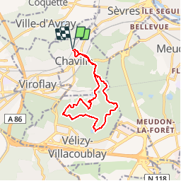
Trail Walking of 11.4 km to be discovered at Ile-de-France, Hauts-de-Seine, Chaville. This trail is proposed by tracegps.
Description
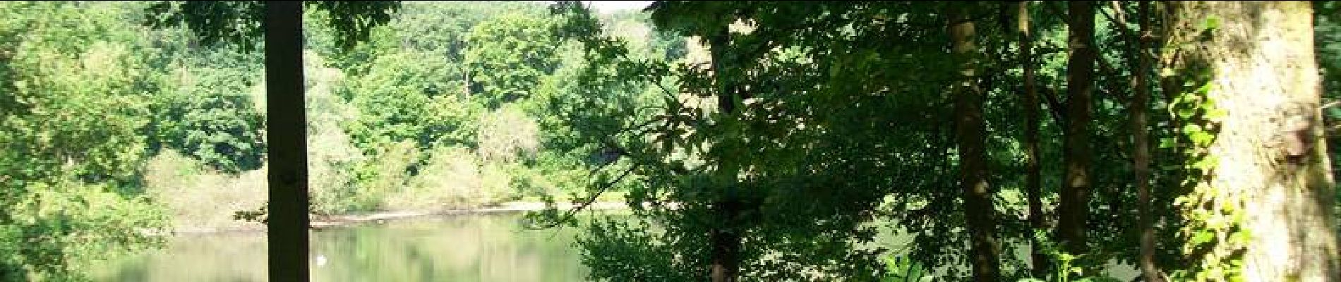
Circuit en boucle à partir de la gare de Chaville RD. Parcours dans la forêt de Meudon, en passant par les étangs du Trou au Gant et des Ursines. Bonne randonnée ! Daniel Baijot - Contact: danielyvesbaijot (at) yahoo.fr
Positioning
Country:
France
Region :
Ile-de-France
Department/Province :
Hauts-de-Seine
Municipality :
Chaville
Location:
Unknown
Start:(Dec)
Start:(UTM)
440389 ; 5406893 (31U) N.
Comments
Trails nearby
![Trail Walking Chaville - Le Sentier des 7 étangs - Photo](https://media.geolcdn.com/t/375/260/ext.jpg?maxdim=2&url=https%3A%2F%2Fservices.sitytrail.com%2FGeolivesWS%2FDownloadMedia.ashx%3FTrailID%3D110203%26Media%3D5435_1.jpg)
![Walking Walking](https://static1.geolcdn.com/sitytour/trail-icons/101.png)
Le Sentier des 7 étangs
Walking
Difficult
(5)
Chaville,
Ile-de-France,
Hauts-de-Seine,
France
![](/images/other/stat-length.png)
23 km | 31 km-effort
5h 0min
![](https://static1.geolcdn.com/siteimages/upload/files/16400158638029165_repeat_loop_refresh_sync_direction_icon.png)
Yes
![Trail Walking Chaville - GRP CV-IDF 20R Chaville à Vaucresson - Photo](https://media.geolcdn.com/t/375/260/ee9d0d3a-696b-449f-af8b-f1928f5c8b40.jpg&format=jpg&maxdim=2)
![Walking Walking](https://static1.geolcdn.com/sitytour/trail-icons/101.png)
GRP CV-IDF 20R Chaville à Vaucresson
Walking
Medium
(1)
Chaville,
Ile-de-France,
Hauts-de-Seine,
France
![](/images/other/stat-length.png)
8.2 km | 11.1 km-effort
2h 30min
![](https://static1.geolcdn.com/siteimages/upload/files/16400158638029165_repeat_loop_refresh_sync_direction_icon.png)
No
![Trail Walking Jouy-en-Josas - GRP CV-IDF 2023 - Photo](https://media.geolcdn.com/t/375/260/0b37f40c-1685-409c-9ec1-27f69abf4580.jpg&format=jpg&maxdim=2)
![Walking Walking](https://static1.geolcdn.com/sitytour/trail-icons/101.png)
GRP CV-IDF 2023
Walking
Difficult
(1)
Jouy-en-Josas,
Ile-de-France,
Yvelines,
France
![](/images/other/stat-length.png)
11.2 km | 14.5 km-effort
3h 17min
![](https://static1.geolcdn.com/siteimages/upload/files/16400158638029165_repeat_loop_refresh_sync_direction_icon.png)
No
![Trail Walking Viroflay - Les 3 Forêts; Meudon, Fausses Reposes et Versailles - Photo](https://media.geolcdn.com/t/375/260/ext.jpg?maxdim=2&url=https%3A%2F%2Fservices.sitytrail.com%2FGeolivesWS%2FDownloadMedia.ashx%3FTrailID%3D110157%26Media%3D5357_1.jpg)
![Walking Walking](https://static1.geolcdn.com/sitytour/trail-icons/101.png)
Les 3 Forêts; Meudon, Fausses Reposes et Versailles
Walking
Difficult
(2)
Viroflay,
Ile-de-France,
Yvelines,
France
![](/images/other/stat-length.png)
25 km | 32 km-effort
5h 19min
![](https://static1.geolcdn.com/siteimages/upload/files/16400158638029165_repeat_loop_refresh_sync_direction_icon.png)
Yes
![Trail Walking Chaville - Sentier des deux Forêts - Meudon et Verrières - Photo](https://media.geolcdn.com/t/375/260/ext.jpg?maxdim=2&url=https%3A%2F%2Fservices.sitytrail.com%2FGeolivesWS%2FDownloadMedia.ashx%3FTrailID%3D110156%26Media%3D5356_1.jpg)
![Walking Walking](https://static1.geolcdn.com/sitytour/trail-icons/101.png)
Sentier des deux Forêts - Meudon et Verrières
Walking
Difficult
(2)
Chaville,
Ile-de-France,
Hauts-de-Seine,
France
![](/images/other/stat-length.png)
23 km | 29 km-effort
5h 0min
![](https://static1.geolcdn.com/siteimages/upload/files/16400158638029165_repeat_loop_refresh_sync_direction_icon.png)
Yes
![Trail Walking Buc - Le Tour de Satory - Photo](https://media.geolcdn.com/t/375/260/ext.jpg?maxdim=2&url=https%3A%2F%2Fservices.sitytrail.com%2FGeolivesWS%2FDownloadMedia.ashx%3FTrailID%3D110070%26Media%3D5206_1.jpg)
![Walking Walking](https://static1.geolcdn.com/sitytour/trail-icons/101.png)
Le Tour de Satory
Walking
Difficult
(2)
Buc,
Ile-de-France,
Yvelines,
France
![](/images/other/stat-length.png)
23 km | 28 km-effort
4h 49min
![](https://static1.geolcdn.com/siteimages/upload/files/16400158638029165_repeat_loop_refresh_sync_direction_icon.png)
Yes
![Trail Walking Boulogne-Billancourt - Parc de St Cloud et forêt de Fausses Reposes - Photo](https://media.geolcdn.com/t/375/260/ext.jpg?maxdim=2&url=https%3A%2F%2Fservices.sitytrail.com%2FGeolivesWS%2FDownloadMedia.ashx%3FTrailID%3D106613%26Media%3D11213_2.jpg)
![Walking Walking](https://static1.geolcdn.com/sitytour/trail-icons/101.png)
Parc de St Cloud et forêt de Fausses Reposes
Walking
Medium
(1)
Boulogne-Billancourt,
Ile-de-France,
Hauts-de-Seine,
France
![](/images/other/stat-length.png)
18.2 km | 23 km-effort
4h 30min
![](https://static1.geolcdn.com/siteimages/upload/files/16400158638029165_repeat_loop_refresh_sync_direction_icon.png)
No
![Trail On foot Boulogne-Billancourt - Boulogne - Marne la Coquette - Ville d'Avray - Meudon - Photo](https://media.geolcdn.com/t/375/260/fed6b7bc-76e0-4d10-9619-38a76fb662e3.jpg&format=jpg&maxdim=2)
![On foot On foot](https://static1.geolcdn.com/sitytour/trail-icons/100.png)
Boulogne - Marne la Coquette - Ville d'Avray - Meudon
On foot
Difficult
Boulogne-Billancourt,
Ile-de-France,
Hauts-de-Seine,
France
![](/images/other/stat-length.png)
29 km | 36 km-effort
8h 9min
![](https://static1.geolcdn.com/siteimages/upload/files/16400158638029165_repeat_loop_refresh_sync_direction_icon.png)
No
![Trail Walking Versailles - 20240828_100557 - Photo](https://media.geolcdn.com/t/375/260/0408d080-39aa-4237-87eb-b73399a86f56.jpg&format=jpg&maxdim=2)
![Walking Walking](https://static1.geolcdn.com/sitytour/trail-icons/101.png)
20240828_100557
Walking
Very difficult
Versailles,
Ile-de-France,
Yvelines,
France
![](/images/other/stat-length.png)
19.7 km | 25 km-effort
5h 34min
![](https://static1.geolcdn.com/siteimages/upload/files/16400158638029165_repeat_loop_refresh_sync_direction_icon.png)
Yes