![](/images/other/stat-length.png)
![Trail Walking Comus - Sentier Cathare - De Comus à Espezel - Photo](https://media.geolcdn.com/t/1900/400/ext.pjpeg?maxdim=2&url=https%3A%2F%2Fservices.sitytrail.com%2FGeolivesWS%2FDownloadMedia.ashx%3FTrailID%3D106622%26Media%3D11232_4.jpg)
Sentier Cathare - De Comus à Espezel
tracegps
User
![Length](/images/other/stat-length.png)
![Max alt](https://static1.geolcdn.com/siteimages/upload/files/1508320355ic_sort_altitude_max_24dp.png)
![Uphill gradient](https://static1.geolcdn.com/siteimages/upload/files/1508320355ic_sort_den_pos_24dp.png)
![Km-Effort](/images/other/stat-length.png)
![Min alt](https://static1.geolcdn.com/siteimages/upload/files/1508320355ic_sort_altitude_min_24dp.png)
![Downhill gradient](https://static1.geolcdn.com/siteimages/upload/files/1508320355ic_sort_den_neg_24dp.png)
![Boucle](https://static1.geolcdn.com/siteimages/upload/files/16400158638029165_repeat_loop_refresh_sync_direction_icon.png)
![Walking](https://static1.geolcdn.com/sitytour/trail-icons/101.png)
5h30
Difficulty : Medium
![Scan this QR Code to open this trail in the SityTrail application](https://capi.geolives.com/qq0zvz2zws4bq2lad0pu/sitytour/trails/106622/qr.png?size=200)
FREE GPS app for hiking
About
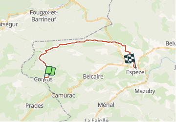
Trail Walking of 19.9 km to be discovered at Occitania, Aude, Comus. This trail is proposed by tracegps.
Description
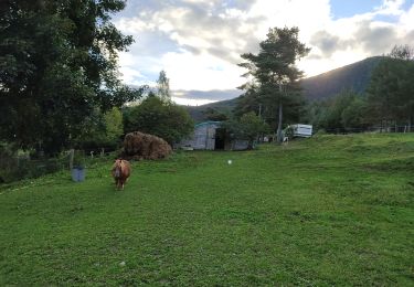
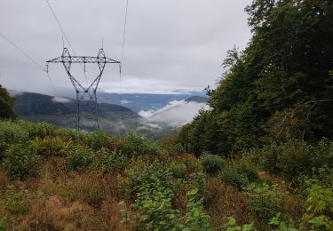
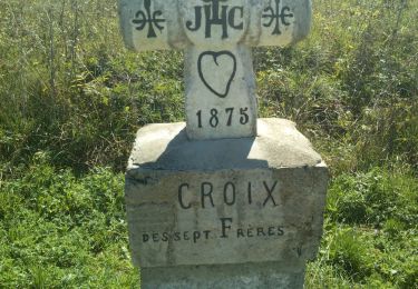
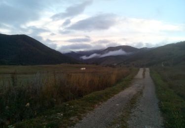
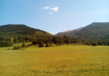
Etape 2 Facile sur 21 kms et peu de dénivelé 300 m. Départ du beau village de Comus, passage sur les estives. Traversée de belles forêts et vue sur les sommets dont le St Bathélémy et la mine de Talc. En surplombant les gorges faire doucement, tenue des isards. Traversée du pays de Saut par des paysages magnifiques. Une très belle étape qui se termine à Espezel et ses commerces pour refaire le plein. Camping municipal et un gite et avec une cuisine locale que vous n'oublierez pas: Chez Louis. Pas de point d'eau sur le parcours.
Positioning
Comments
Trails nearby
![Trail Walking Prades - Pic Fourcat Prades - Photo](https://media.geolcdn.com/t/375/260/7328a631-1f70-4385-b122-8064227fbc3d.jpg&format=jpg&maxdim=2)
![Walking Walking](https://static1.geolcdn.com/sitytour/trail-icons/101.png)
Walking
![](/images/other/stat-length.png)
![](https://static1.geolcdn.com/siteimages/upload/files/16400158638029165_repeat_loop_refresh_sync_direction_icon.png)
![Trail Snowshoes Montaillou - Montaillou - Quercourt - Cassaula - Photo](https://media.geolcdn.com/t/375/260/77edc5f4-b2bc-4200-8c88-de065acc055d.jpg&format=jpg&maxdim=2)
![Snowshoes Snowshoes](https://static1.geolcdn.com/sitytour/trail-icons/504.png)
Snowshoes
![](/images/other/stat-length.png)
![](https://static1.geolcdn.com/siteimages/upload/files/16400158638029165_repeat_loop_refresh_sync_direction_icon.png)
![Trail Walking Camurac - Les cretes de Camurac 2021 - Photo](https://media.geolcdn.com/t/375/260/5d50d82b-2d5f-4a5c-b7c9-2ca11180f548.jpg&format=jpg&maxdim=2)
![Walking Walking](https://static1.geolcdn.com/sitytour/trail-icons/101.png)
Walking
![](/images/other/stat-length.png)
![](https://static1.geolcdn.com/siteimages/upload/files/16400158638029165_repeat_loop_refresh_sync_direction_icon.png)
![Trail Walking Caussou - le col des canons - Photo](https://media.geolcdn.com/t/375/260/0af39750-734d-4928-98d9-54c1892ac07f.jpg&format=jpg&maxdim=2)
![Walking Walking](https://static1.geolcdn.com/sitytour/trail-icons/101.png)
Walking
![](/images/other/stat-length.png)
![](https://static1.geolcdn.com/siteimages/upload/files/16400158638029165_repeat_loop_refresh_sync_direction_icon.png)
![Trail Walking Camurac - Les sept frères - Photo](https://media.geolcdn.com/t/375/260/930344b5-c8d1-433a-8942-f0db24583848.jpg&format=jpg&maxdim=2)
![Walking Walking](https://static1.geolcdn.com/sitytour/trail-icons/101.png)
![Trail Walking Camurac - Tour du Boum - Photo](https://media.geolcdn.com/t/375/260/f82072ee-8895-43c7-93a7-3d8b770c547f.jpg&format=jpg&maxdim=2)
![Walking Walking](https://static1.geolcdn.com/sitytour/trail-icons/101.png)
![Trail Walking Camurac - les crêtes de Camurac - Photo](https://media.geolcdn.com/t/375/260/0e23b182-c13b-4448-ac03-8af9a97bb651.jpg&format=jpg&maxdim=2)
![Walking Walking](https://static1.geolcdn.com/sitytour/trail-icons/101.png)
Walking
![](/images/other/stat-length.png)
![](https://static1.geolcdn.com/siteimages/upload/files/16400158638029165_repeat_loop_refresh_sync_direction_icon.png)
![Trail Mountain bike Belcaire - Tour des châteaux du Pays Cathare - Belcaire - Puivert - Photo](https://media.geolcdn.com/t/375/260/ext.jpg?maxdim=2&url=https%3A%2F%2Fservices.sitytrail.com%2FGeolivesWS%2FDownloadMedia.ashx%3FTrailID%3D108169%26Media%3D599_3.jpg)
![Mountain bike Mountain bike](https://static1.geolcdn.com/sitytour/trail-icons/202.png)
Mountain bike
![](/images/other/stat-length.png)
![](https://static1.geolcdn.com/siteimages/upload/files/16400158638029165_repeat_loop_refresh_sync_direction_icon.png)
![Trail Mountain bike Camurac - Du sentier Cathare à Espéraza - Photo](https://media.geolcdn.com/t/375/260/ext.jpg?maxdim=2&url=https%3A%2F%2Fservices.sitytrail.com%2FGeolivesWS%2FDownloadMedia.ashx%3FTrailID%3D106651%26Media%3D11263_6.jpg)
![Mountain bike Mountain bike](https://static1.geolcdn.com/sitytour/trail-icons/202.png)
Mountain bike
![](/images/other/stat-length.png)
![](https://static1.geolcdn.com/siteimages/upload/files/16400158638029165_repeat_loop_refresh_sync_direction_icon.png)