Trail Mountain bike Donzac - Les sentiers du Brulhois - Donzac - Photo

Les sentiers du Brulhois - Donzac

 tracegps
tracegps

User

© OpenStreetMap contributors
Length
Length
40 km
Max alt
Max alt
192 m
Uphill gradient
Uphill gradient
634 m
Km-Effort
Km-Effort  
48 km
Min alt
Min alt
66 m
Downhill gradient
Downhill gradient
633 m
Boucle
Boucle
Yes
Creation date :
2014-12-10 00:00:00.0
Updated on :
2014-12-10 00:00:00.0

(0 Reviews)

Mountain bike
Mountain bike
2h45
Difficulty : Medium

Scan this QR Code to open this trail in the SityTrail application

FREE GPS app for hiking

Logo SityTrail SityTrail

IGN / Geographical institutes

Download SityTrail from the App Store Download SityTrail from Google Play

Logo SityTrail SityTrail World

The world is yours!

Download SityTrail from the App Store Download SityTrail from Google Play Download SityTrail on Huawei AppGallery

About

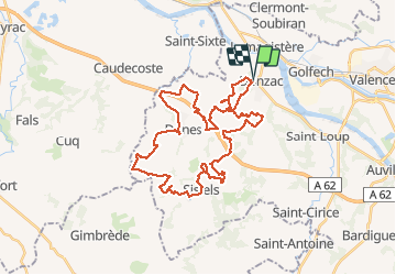
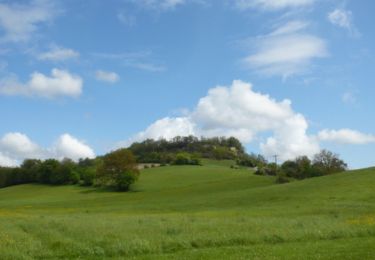
Trail Mountain bike of 40 km to be discovered at Occitania, Tarn-et-Garonne, Donzac. This trail is proposed by tracegps.

Description

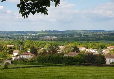
Les "Sentiers du Brulhois" est un ensemble de plusieurs circuit de petite randonnée conçues pour les pédestres, les VTT et les cavaliers (certaines portions sont accessibles aux attelages) au sud du territoire de la Communauté de Communes des Deux Rives. Quatre itinéraires de longueurs différentes vous sont proposés à partir des villages de Donzac, Dunes, Sistels et Saint-Loup. A travers ces balades de quelques heures, vous découvrirez les paysages vallonnés du Brulhois, le patrimoine architectural des bastides gasconnes ainsi que le charme des villages fleuris. La brochure contenant les circuits est disponible en mairie et à l'Office du Tourisme de Donzac, ou en téléchargement ICI. A voir sur le circuit la Bastide de Dunes, le vignoble du Brulhois, le village de Sistels, la Tour des Templiers et les points de vue sur la vallée de l’Auroue.

Elevation profile

Photos

Positioning

Country:
France
Region :
Occitania
Department/Province :
Tarn-et-Garonne
Municipality :
Donzac
Location:
Unknown
Start:(UTM)
325200 ; 4886416 (31T) N.

Trails nearby

Trail Walking Clermont-Soubiran - Coteaux depuis maison Roiatti  - Photo
Walking
jlc12

Walking

Medium
Clermont-Soubiran, New Aquitaine, Lot-et-Garonne, France
4.1 km | 5.5 km-effort
1h 7min
Yes
Trail Walking Clermont-Soubiran - coupet autour de labro - Photo
Walking
jlc12

Walking

Medium
(2)
Clermont-Soubiran, New Aquitaine, Lot-et-Garonne, France
11.5 km | 14.7 km-effort
3h 11min
Yes
Trail Walking Clermont-Soubiran - Les Acacias-Ebrard-Labro - Photo
Walking
jlc12

Walking

Difficult
Clermont-Soubiran, New Aquitaine, Lot-et-Garonne, France
3.6 km | 4.9 km-effort
1h 25min
No
Trail Walking Saint-Loup - Saint Lou sud - Photo
Walking
jlc12

Walking

Difficult
Saint-Loup, Occitania, Tarn-et-Garonne, France
9.5 km | 12.1 km-effort
2h 31min
No
Trail Walking Lamagistère - Coupet retenue canal lac bleu - Photo
Walking
jlc12

Walking

Easy
Lamagistère, Occitania, Tarn-et-Garonne, France
11.1 km | 12 km-effort
1h 25min
Yes
Trail Mountain bike Saint-Loup - Circuit de Cachepiot - Saint Loup - Photo
Mountain bike
tracegps

Mountain bike

Medium
Saint-Loup, Occitania, Tarn-et-Garonne, France
9.6 km | 12.5 km-effort
45min
Yes
Trail Walking Saint-Loup - Circuit de Cachepiot - Saint Loup - Photo
Walking
tracegps

Walking

Easy
Saint-Loup, Occitania, Tarn-et-Garonne, France
9.6 km | 12.5 km-effort
1h 30min
Yes
Trail Cycle Clermont-Soubiran - Voie Verte du Canal de Garonne - Laspeyres - Meilhan sur Garonne  - Photo
Cycle
tracegps

Cycle

Medium
Clermont-Soubiran, New Aquitaine, Lot-et-Garonne, France
88 km | 98 km-effort
4h 30min
No
Trail Mountain bike Clermont-Soubiran - Clermont-Soubiran, des coteaux du Pays de Serres au Canal de Garonne - Pays de l'Agenais - Photo
Mountain bike
tracegps

Mountain bike

Difficult
Clermont-Soubiran, New Aquitaine, Lot-et-Garonne, France
21 km | 27 km-effort
2h 49min
Yes


Close
My subscriptions