![](/images/other/stat-length.png)
![Trail Mountain bike Valence - Les coteaux de Valence - Photo](https://media.geolcdn.com/t/1900/400/ext.pjpeg?maxdim=2&url=https%3A%2F%2Fstatic1.geolcdn.com%2Fsiteimages%2Fupload%2Ffiles%2F1524743154velo.jpg)
Les coteaux de Valence
tracegps
User
![Length](/images/other/stat-length.png)
Length
33 km
![Max alt](https://static1.geolcdn.com/siteimages/upload/files/1508320355ic_sort_altitude_max_24dp.png)
Max alt
171 m
![Uphill gradient](https://static1.geolcdn.com/siteimages/upload/files/1508320355ic_sort_den_pos_24dp.png)
Uphill gradient
745 m
![Km-Effort](/images/other/stat-length.png)
Km-Effort
43 km
![Min alt](https://static1.geolcdn.com/siteimages/upload/files/1508320355ic_sort_altitude_min_24dp.png)
Min alt
55 m
![Downhill gradient](https://static1.geolcdn.com/siteimages/upload/files/1508320355ic_sort_den_neg_24dp.png)
Downhill gradient
748 m
![Boucle](https://static1.geolcdn.com/siteimages/upload/files/16400158638029165_repeat_loop_refresh_sync_direction_icon.png)
Boucle
Yes
Creation date :
2014-12-10 00:00:00.0
Updated on :
2014-12-10 00:00:00.0
![Mountain bike](https://static1.geolcdn.com/sitytour/trail-icons/202.png)
2h30
Difficulty : Difficult
![Scan this QR Code to open this trail in the SityTrail application](https://capi.geolives.com/qq0zvz2zws4bq2lad0pu/sitytour/trails/106561/qr.png?size=200)
FREE GPS app for hiking
About
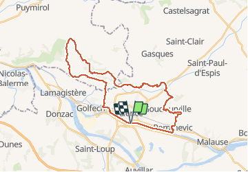
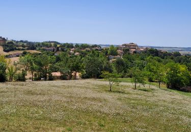
Trail Mountain bike of 33 km to be discovered at Occitania, Tarn-et-Garonne, Valence. This trail is proposed by tracegps.
Description
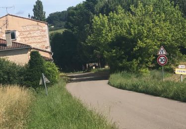
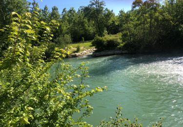
Découverte du canal, puis Pommevic, les coteaux de Goudourville, La Lande, le vignoble de Cornillas, Clermont Soubiran, Coupet et retour par le canal Entre Deux Mers.
Positioning
Country:
France
Region :
Occitania
Department/Province :
Tarn-et-Garonne
Municipality :
Valence
Location:
Unknown
Start:(Dec)
Start:(UTM)
331364 ; 4885599 (31T) N.
Comments
Trails nearby
![Trail sport Gasques - 25/08/2024 - Photo](https://media.geolcdn.com/t/375/260/3bb079de-14ec-49d8-82bc-63caf27cc572.jpg&format=jpg&maxdim=2)
25/08/2024
sport
Very easy
Gasques,
Occitania,
Tarn-et-Garonne,
France
![](/images/other/stat-length.png)
9.4 km | 12.2 km-effort
Unknown
![](https://static1.geolcdn.com/siteimages/upload/files/16400158638029165_repeat_loop_refresh_sync_direction_icon.png)
No
![Trail sport Valence - 08/07/2024 - Photo](https://media.geolcdn.com/t/375/260/02acc9ee-7c4c-41fe-bef4-167218db40e8.jpg&format=jpg&maxdim=2)
08/07/2024
sport
Very easy
Valence,
Occitania,
Tarn-et-Garonne,
France
![](/images/other/stat-length.png)
7.8 km | 9.5 km-effort
Unknown
![](https://static1.geolcdn.com/siteimages/upload/files/16400158638029165_repeat_loop_refresh_sync_direction_icon.png)
Yes
![Trail sport Valence - 05/07/2024 - Photo](https://media.geolcdn.com/t/375/260/84bb87fd-d366-464e-b431-244375a9f25d.jpg&format=jpg&maxdim=2)
05/07/2024
sport
Very easy
Valence,
Occitania,
Tarn-et-Garonne,
France
![](/images/other/stat-length.png)
11.7 km | 12.6 km-effort
Unknown
![](https://static1.geolcdn.com/siteimages/upload/files/16400158638029165_repeat_loop_refresh_sync_direction_icon.png)
Yes
![Trail sport Valence - Ballade 29/06/24 - Photo](https://media.geolcdn.com/t/375/260/74cd2fc9-f021-476e-b08b-146858c09e5c.jpg&format=jpg&maxdim=2)
Ballade 29/06/24
sport
Very easy
Valence,
Occitania,
Tarn-et-Garonne,
France
![](/images/other/stat-length.png)
11.6 km | 13.6 km-effort
Unknown
![](https://static1.geolcdn.com/siteimages/upload/files/16400158638029165_repeat_loop_refresh_sync_direction_icon.png)
Yes
![Trail sport Valence - Lundi 22avril 2024 - Photo](https://media.geolcdn.com/t/375/260/aa7242f5-a0f4-4f88-9610-5938dbe858ee.jpg&format=jpg&maxdim=2)
Lundi 22avril 2024
sport
Very easy
Valence,
Occitania,
Tarn-et-Garonne,
France
![](/images/other/stat-length.png)
10.5 km | 12.7 km-effort
Unknown
![](https://static1.geolcdn.com/siteimages/upload/files/16400158638029165_repeat_loop_refresh_sync_direction_icon.png)
Yes
![Trail sport Valence - Les marcheurs du Pontus 18 avril 2024 - Photo](https://media.geolcdn.com/t/375/260/462dfb00-e608-49e4-92cf-bae19c6c9ef9.jpg&format=jpg&maxdim=2)
Les marcheurs du Pontus 18 avril 2024
sport
Very easy
Valence,
Occitania,
Tarn-et-Garonne,
France
![](/images/other/stat-length.png)
10.8 km | 11.7 km-effort
Unknown
![](https://static1.geolcdn.com/siteimages/upload/files/16400158638029165_repeat_loop_refresh_sync_direction_icon.png)
Yes
![Trail Walking Auvillar - auvillar mirandoux - Photo](https://media.geolcdn.com/t/375/260/6f195b95-5de6-4c93-9d2d-fc2a6ae4f795.jpg&format=jpg&maxdim=2)
![Walking Walking](https://static1.geolcdn.com/sitytour/trail-icons/101.png)
auvillar mirandoux
Walking
Medium
Auvillar,
Occitania,
Tarn-et-Garonne,
France
![](/images/other/stat-length.png)
17.3 km | 23 km-effort
4h 26min
![](https://static1.geolcdn.com/siteimages/upload/files/16400158638029165_repeat_loop_refresh_sync_direction_icon.png)
No
![Trail Walking Clermont-Soubiran - Coteaux depuis maison Roiatti - Photo](https://media.geolcdn.com/t/375/260/00d8c168-eeb7-45cf-a950-8b81643238bd.jpg&format=jpg&maxdim=2)
![Walking Walking](https://static1.geolcdn.com/sitytour/trail-icons/101.png)
Coteaux depuis maison Roiatti
Walking
Medium
Clermont-Soubiran,
New Aquitaine,
Lot-et-Garonne,
France
![](/images/other/stat-length.png)
4.1 km | 5.5 km-effort
1h 7min
![](https://static1.geolcdn.com/siteimages/upload/files/16400158638029165_repeat_loop_refresh_sync_direction_icon.png)
Yes
![Trail Walking Clermont-Soubiran - coupet autour de labro - Photo](https://media.geolcdn.com/t/375/260/ext.jpg?maxdim=2&url=https%3A%2F%2Fstatic1.geolcdn.com%2Fsiteimages%2Fupload%2Ffiles%2F1553511878bg_sport_marche.png)
![Walking Walking](https://static1.geolcdn.com/sitytour/trail-icons/101.png)
coupet autour de labro
Walking
Medium
(2)
Clermont-Soubiran,
New Aquitaine,
Lot-et-Garonne,
France
![](/images/other/stat-length.png)
11.5 km | 14.7 km-effort
3h 11min
![](https://static1.geolcdn.com/siteimages/upload/files/16400158638029165_repeat_loop_refresh_sync_direction_icon.png)
Yes