![](/images/other/stat-length.png)
![Trail Walking Bost - Les Gouttes Noires - Bost - Photo](https://media.geolcdn.com/t/1900/400/ext.pjpeg?maxdim=2&url=https%3A%2F%2Fservices.sitytrail.com%2FGeolivesWS%2FDownloadMedia.ashx%3FTrailID%3D106560%26Media%3D11131_5.jpg)
Les Gouttes Noires - Bost
tracegps
User
![Length](/images/other/stat-length.png)
Length
14.4 km
![Max alt](https://static1.geolcdn.com/siteimages/upload/files/1508320355ic_sort_altitude_max_24dp.png)
Max alt
481 m
![Uphill gradient](https://static1.geolcdn.com/siteimages/upload/files/1508320355ic_sort_den_pos_24dp.png)
Uphill gradient
304 m
![Km-Effort](/images/other/stat-length.png)
Km-Effort
18.4 km
![Min alt](https://static1.geolcdn.com/siteimages/upload/files/1508320355ic_sort_altitude_min_24dp.png)
Min alt
269 m
![Downhill gradient](https://static1.geolcdn.com/siteimages/upload/files/1508320355ic_sort_den_neg_24dp.png)
Downhill gradient
304 m
![Boucle](https://static1.geolcdn.com/siteimages/upload/files/16400158638029165_repeat_loop_refresh_sync_direction_icon.png)
Boucle
Yes
Creation date :
2014-12-10 00:00:00.0
Updated on :
2014-12-10 00:00:00.0
![Walking](https://static1.geolcdn.com/sitytour/trail-icons/101.png)
3h34
Difficulty : Medium
![Scan this QR Code to open this trail in the SityTrail application](https://capi.geolives.com/qq0zvz2zws4bq2lad0pu/sitytour/trails/106560/qr.png?size=200)
FREE GPS app for hiking
About
Trail Walking of 14.4 km to be discovered at Auvergne-Rhône-Alpes, Allier, Bost. This trail is proposed by tracegps.
Description
La douceur et la beauté des vues et du patrimoine bâti récompensent les efforts! Vues sur la montagne Bourbonnaise, à travers le bois de Celsat et le hameau des Acarins.
Positioning
Country:
France
Region :
Auvergne-Rhône-Alpes
Department/Province :
Allier
Municipality :
Bost
Location:
Unknown
Start:(Dec)
Start:(UTM)
539944 ; 5114026 (31T) N.
Comments
Trails nearby
![Trail Walking Bost - AVF reconnaissance Bost - Photo](https://media.geolcdn.com/t/375/260/ext.jpg?maxdim=2&url=https%3A%2F%2Fstatic1.geolcdn.com%2Fsiteimages%2Fupload%2Ffiles%2F1553511878bg_sport_marche.png)
![Walking Walking](https://static1.geolcdn.com/sitytour/trail-icons/101.png)
AVF reconnaissance Bost
Walking
Difficult
Bost,
Auvergne-Rhône-Alpes,
Allier,
France
![](/images/other/stat-length.png)
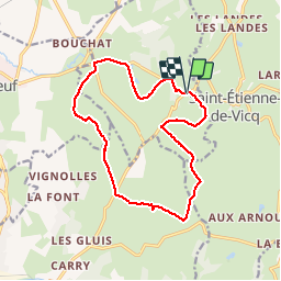
9.9 km | 11.7 km-effort
2h 52min
![](https://static1.geolcdn.com/siteimages/upload/files/16400158638029165_repeat_loop_refresh_sync_direction_icon.png)
Yes
![Trail Walking Bost - bost bof - Photo](https://media.geolcdn.com/t/375/260/2ea7e5ba-20ed-4199-8b96-a4e8082f4455.jpg&format=jpg&maxdim=2)
![Walking Walking](https://static1.geolcdn.com/sitytour/trail-icons/101.png)
bost bof
Walking
Medium
Bost,
Auvergne-Rhône-Alpes,
Allier,
France
![](/images/other/stat-length.png)
13.5 km | 17.4 km-effort
3h 43min
![](https://static1.geolcdn.com/siteimages/upload/files/16400158638029165_repeat_loop_refresh_sync_direction_icon.png)
Yes
![Trail Walking Bost - Randonnée, Les, goutte Noire, Vichy, 2023 - Photo](https://media.geolcdn.com/t/375/260/ext.jpg?maxdim=2&url=https%3A%2F%2Fstatic1.geolcdn.com%2Fsiteimages%2Fupload%2Ffiles%2F1553511878bg_sport_marche.png)
![Walking Walking](https://static1.geolcdn.com/sitytour/trail-icons/101.png)
Randonnée, Les, goutte Noire, Vichy, 2023
Walking
Medium
Bost,
Auvergne-Rhône-Alpes,
Allier,
France
![](/images/other/stat-length.png)
7.1 km | 9.7 km-effort
1h 45min
![](https://static1.geolcdn.com/siteimages/upload/files/16400158638029165_repeat_loop_refresh_sync_direction_icon.png)
Yes
![Trail Walking Saint-Étienne-de-Vicq - La Bruyère - Saint Christophe - Photo](https://media.geolcdn.com/t/375/260/ext.jpg?maxdim=2&url=https%3A%2F%2Fstatic1.geolcdn.com%2Fsiteimages%2Fupload%2Ffiles%2F1553511878bg_sport_marche.png)
![Walking Walking](https://static1.geolcdn.com/sitytour/trail-icons/101.png)
La Bruyère - Saint Christophe
Walking
Very difficult
Saint-Étienne-de-Vicq,
Auvergne-Rhône-Alpes,
Allier,
France
![](/images/other/stat-length.png)
17.4 km | 22 km-effort
4h 46min
![](https://static1.geolcdn.com/siteimages/upload/files/16400158638029165_repeat_loop_refresh_sync_direction_icon.png)
Yes
![Trail Other activity Saint-Étienne-de-Vicq - st etienne de vicq - Photo](https://media.geolcdn.com/t/375/260/ext.jpg?maxdim=2&url=https%3A%2F%2Fstatic1.geolcdn.com%2Fsiteimages%2Fupload%2Ffiles%2F1545311037marcheuse_200dpi.jpg)
![Other activity Other activity](https://static1.geolcdn.com/sitytour/trail-icons/900.png)
st etienne de vicq
Other activity
Very easy
Saint-Étienne-de-Vicq,
Auvergne-Rhône-Alpes,
Allier,
France
![](/images/other/stat-length.png)
12.6 km | 16.7 km-effort
3h 14min
![](https://static1.geolcdn.com/siteimages/upload/files/16400158638029165_repeat_loop_refresh_sync_direction_icon.png)
Yes
![Trail Other activity Saint-Étienne-de-Vicq - st etienn'e - Photo](https://media.geolcdn.com/t/375/260/ext.jpg?maxdim=2&url=https%3A%2F%2Fstatic1.geolcdn.com%2Fsiteimages%2Fupload%2Ffiles%2F1545311037marcheuse_200dpi.jpg)
![Other activity Other activity](https://static1.geolcdn.com/sitytour/trail-icons/900.png)
st etienn'e
Other activity
Very easy
Saint-Étienne-de-Vicq,
Auvergne-Rhône-Alpes,
Allier,
France
![](/images/other/stat-length.png)
11.9 km | 13.7 km-effort
2h 51min
![](https://static1.geolcdn.com/siteimages/upload/files/16400158638029165_repeat_loop_refresh_sync_direction_icon.png)
Yes