![](/images/other/stat-length.png)
![Trail Mountain bike Sigean - Tour étang Bages - Sigean - Photo](https://media.geolcdn.com/t/1900/400/ext.pjpeg?maxdim=2&url=https%3A%2F%2Fstatic1.geolcdn.com%2Fsiteimages%2Fupload%2Ffiles%2F1524743154velo.jpg)
Tour étang Bages - Sigean
tracegps
User
![Length](/images/other/stat-length.png)
Length
57 km
![Max alt](https://static1.geolcdn.com/siteimages/upload/files/1508320355ic_sort_altitude_max_24dp.png)
Max alt
116 m
![Uphill gradient](https://static1.geolcdn.com/siteimages/upload/files/1508320355ic_sort_den_pos_24dp.png)
Uphill gradient
591 m
![Km-Effort](/images/other/stat-length.png)
Km-Effort
65 km
![Min alt](https://static1.geolcdn.com/siteimages/upload/files/1508320355ic_sort_altitude_min_24dp.png)
Min alt
-3 m
![Downhill gradient](https://static1.geolcdn.com/siteimages/upload/files/1508320355ic_sort_den_neg_24dp.png)
Downhill gradient
594 m
![Boucle](https://static1.geolcdn.com/siteimages/upload/files/16400158638029165_repeat_loop_refresh_sync_direction_icon.png)
Boucle
Yes
Creation date :
2014-12-10 00:00:00.0
Updated on :
2014-12-10 00:00:00.0
![Mountain bike](https://static1.geolcdn.com/sitytour/trail-icons/202.png)
5h30
Difficulty : Difficult
![Scan this QR Code to open this trail in the SityTrail application](https://capi.geolives.com/qq0zvz2zws4bq2lad0pu/sitytour/trails/106542/qr.png?size=200)
FREE GPS app for hiking
About
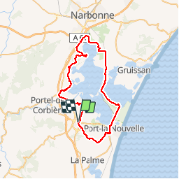
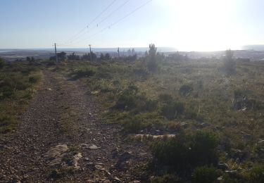
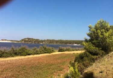
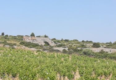
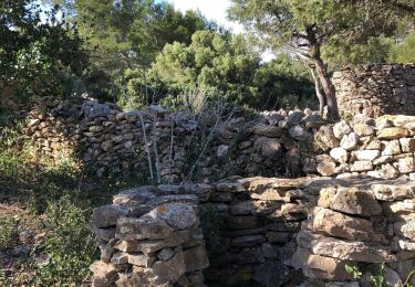
Trail Mountain bike of 57 km to be discovered at Occitania, Aude, Sigean. This trail is proposed by tracegps.
Description
Tour cherché et réussi, au plus près de ces étangs : un must. Attention au secteur au nord de Sigean autour de La Coutive et au dessus de Port la Nouvelle très cassant avant d'arriver aux éoliennes.
Positioning
Country:
France
Region :
Occitania
Department/Province :
Aude
Municipality :
Sigean
Location:
Unknown
Start:(Dec)
Start:(UTM)
498129 ; 4764089 (31T) N.
Comments
Trails nearby
![Trail Walking Roquefort-des-Corbières - Roquefort des Corbières Jean 17.04.22 - Photo](https://media.geolcdn.com/t/375/260/df7e706c-86b4-4f41-b4d6-da42e79bf632.jpg&format=jpg&maxdim=2)
![Walking Walking](https://static1.geolcdn.com/sitytour/trail-icons/101.png)
Roquefort des Corbières Jean 17.04.22
Walking
Medium
(1)
Roquefort-des-Corbières,
Occitania,
Aude,
France
![](/images/other/stat-length.png)
15.3 km | 22 km-effort
3h 46min
![](https://static1.geolcdn.com/siteimages/upload/files/16400158638029165_repeat_loop_refresh_sync_direction_icon.png)
Yes
![Trail On foot Sigean - Boucle des Cabanes de Port Mahon Sigean - Photo](https://media.geolcdn.com/t/375/260/ext.jpg?maxdim=2&url=https%3A%2F%2Fstatic1.geolcdn.com%2Fsiteimages%2Fupload%2Ffiles%2F1545311037marcheuse_200dpi.jpg)
![On foot On foot](https://static1.geolcdn.com/sitytour/trail-icons/100.png)
Boucle des Cabanes de Port Mahon Sigean
On foot
Medium
(1)
Sigean,
Occitania,
Aude,
France
![](/images/other/stat-length.png)
12.4 km | 13.9 km-effort
3h 20min
![](https://static1.geolcdn.com/siteimages/upload/files/16400158638029165_repeat_loop_refresh_sync_direction_icon.png)
Yes
![Trail Walking Sigean - port mabon - Photo](https://media.geolcdn.com/t/375/260/8dffe964-f9eb-480b-bba3-e465a645cce6.jpg&format=jpg&maxdim=2)
![Walking Walking](https://static1.geolcdn.com/sitytour/trail-icons/101.png)
![Trail Walking Sigean - Les Salins de Sigean - Photo](https://media.geolcdn.com/t/375/260/0c3906c1-ddca-4889-b150-1015072c6404.jpg&format=jpg&maxdim=2)
![Walking Walking](https://static1.geolcdn.com/sitytour/trail-icons/101.png)
Les Salins de Sigean
Walking
Easy
Sigean,
Occitania,
Aude,
France
![](/images/other/stat-length.png)
15.6 km | 17.6 km-effort
4h 30min
![](https://static1.geolcdn.com/siteimages/upload/files/16400158638029165_repeat_loop_refresh_sync_direction_icon.png)
Yes
![Trail Donkey back riding Port-la-Nouvelle - Cathare 1 port la nouvelle Durban Corbieres - Photo](https://media.geolcdn.com/t/375/260/e41ebe21-8688-4101-9289-802a8715a742.jpg&format=jpg&maxdim=2)
![Donkey back riding Donkey back riding](https://static1.geolcdn.com/sitytour/trail-icons/303.png)
Cathare 1 port la nouvelle Durban Corbieres
Donkey back riding
Medium
Port-la-Nouvelle,
Occitania,
Aude,
France
![](/images/other/stat-length.png)
20 km | 26 km-effort
4h 21min
![](https://static1.geolcdn.com/siteimages/upload/files/16400158638029165_repeat_loop_refresh_sync_direction_icon.png)
No
![Trail Walking Roquefort-des-Corbières - Roquefort 161106 - Photo](https://media.geolcdn.com/t/375/260/ext.jpg?maxdim=2&url=https%3A%2F%2Fstatic1.geolcdn.com%2Fsiteimages%2Fupload%2Ffiles%2F1553511878bg_sport_marche.png)
![Walking Walking](https://static1.geolcdn.com/sitytour/trail-icons/101.png)
Roquefort 161106
Walking
Very easy
(1)
Roquefort-des-Corbières,
Occitania,
Aude,
France
![](/images/other/stat-length.png)
20 km | 28 km-effort
7h 5min
![](https://static1.geolcdn.com/siteimages/upload/files/16400158638029165_repeat_loop_refresh_sync_direction_icon.png)
Yes
![Trail Walking Sigean - Sigean - Photo](https://media.geolcdn.com/t/375/260/ext.jpg?maxdim=2&url=https%3A%2F%2Fservices.sitytrail.com%2FGeolivesWS%2FDownloadMedia.ashx%3FTrailID%3D141900%26Media%3D20120728165702.jpg)
![Walking Walking](https://static1.geolcdn.com/sitytour/trail-icons/101.png)
![Trail Walking Roquefort-des-Corbières - boucle pastorale 2019 - Photo](https://media.geolcdn.com/t/375/260/3b7e021d-d9de-4003-8a52-b64e1c3d6460.jpg&format=jpg&maxdim=2)
![Walking Walking](https://static1.geolcdn.com/sitytour/trail-icons/101.png)
boucle pastorale 2019
Walking
Medium
(1)
Roquefort-des-Corbières,
Occitania,
Aude,
France
![](/images/other/stat-length.png)
11.2 km | 15.8 km-effort
4h 26min
![](https://static1.geolcdn.com/siteimages/upload/files/16400158638029165_repeat_loop_refresh_sync_direction_icon.png)
Yes
![Trail Walking Roquefort-des-Corbières - Roquefort des corbières - Photo](https://media.geolcdn.com/t/375/260/18db47b8-dce0-4f72-8752-93e0cd290e29.jpg&format=jpg&maxdim=2)
![Walking Walking](https://static1.geolcdn.com/sitytour/trail-icons/101.png)
Roquefort des corbières
Walking
Medium
Roquefort-des-Corbières,
Occitania,
Aude,
France
![](/images/other/stat-length.png)
14.8 km | 21 km-effort
5h 17min
![](https://static1.geolcdn.com/siteimages/upload/files/16400158638029165_repeat_loop_refresh_sync_direction_icon.png)
Yes