![](/images/other/stat-length.png)
![Trail Walking Roissy-en-Brie - Forêt de Ferrières et Ferrières en Brie - Photo](https://media.geolcdn.com/t/1900/400/ext.pjpeg?maxdim=2&url=https%3A%2F%2Fstatic1.geolcdn.com%2Fsiteimages%2Fupload%2Ffiles%2F1553511878bg_sport_marche.png)
Forêt de Ferrières et Ferrières en Brie
Surot
User
![Length](/images/other/stat-length.png)
Length
14.6 km
![Max alt](https://static1.geolcdn.com/siteimages/upload/files/1508320355ic_sort_altitude_max_24dp.png)
Max alt
123 m
![Uphill gradient](https://static1.geolcdn.com/siteimages/upload/files/1508320355ic_sort_den_pos_24dp.png)
Uphill gradient
97 m
![Km-Effort](/images/other/stat-length.png)
Km-Effort
15.9 km
![Min alt](https://static1.geolcdn.com/siteimages/upload/files/1508320355ic_sort_altitude_min_24dp.png)
Min alt
99 m
![Downhill gradient](https://static1.geolcdn.com/siteimages/upload/files/1508320355ic_sort_den_neg_24dp.png)
Downhill gradient
96 m
![Boucle](https://static1.geolcdn.com/siteimages/upload/files/16400158638029165_repeat_loop_refresh_sync_direction_icon.png)
Boucle
Yes
Creation date :
2019-01-15 18:16:13.144
Updated on :
2023-08-24 13:45:26.933
![Walking](https://static1.geolcdn.com/sitytour/trail-icons/101.png)
3h37
Difficulty : Difficult
![Scan this QR Code to open this trail in the SityTrail application](https://capi.geolives.com/qq0zvz2zws4bq2lad0pu/sitytour/trails/1065291/qr.png?size=200)
FREE GPS app for hiking
About
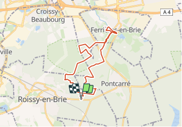
Trail Walking of 14.6 km to be discovered at Ile-de-France, Seine-et-Marne, Roissy-en-Brie. This trail is proposed by Surot.
Description
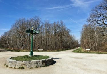
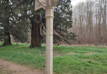
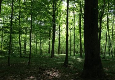
randonnée facile en forêt, sans dénivelé, belle allée des séquoias et joli village de Ferrières en Brie (anciennes buanderie et écuries du chateau, église et café saint Rémy). Sans difficulté, joli site de pique-nique en bord d'étang
Positioning
Country:
France
Region :
Ile-de-France
Department/Province :
Seine-et-Marne
Municipality :
Roissy-en-Brie
Location:
Unknown
Start:(Dec)
Start:(UTM)
476585 ; 5404179 (31U) N.
Comments
Trails nearby
![Trail Walking Émerainville - GRP CV-IDF 05 - Photo](https://media.geolcdn.com/t/375/260/726621e0-1908-4a49-bd96-d431c02673d0.jpg&format=jpg&maxdim=2)
![Walking Walking](https://static1.geolcdn.com/sitytour/trail-icons/101.png)
GRP CV-IDF 05
Walking
Difficult
(1)
Émerainville,
Ile-de-France,
Seine-et-Marne,
France
![](/images/other/stat-length.png)
16.8 km | 18.1 km-effort
4h 6min
![](https://static1.geolcdn.com/siteimages/upload/files/16400158638029165_repeat_loop_refresh_sync_direction_icon.png)
No
![Trail Walking Lésigny - J 28 12 km lesigny cimetiere village gr14 - Photo](https://media.geolcdn.com/t/375/260/ext.jpg?maxdim=2&url=https%3A%2F%2Fstatic1.geolcdn.com%2Fsiteimages%2Fupload%2Ffiles%2F1553511878bg_sport_marche.png)
![Walking Walking](https://static1.geolcdn.com/sitytour/trail-icons/101.png)
J 28 12 km lesigny cimetiere village gr14
Walking
Medium
(4)
Lésigny,
Ile-de-France,
Seine-et-Marne,
France
![](/images/other/stat-length.png)
13 km | 14 km-effort
3h 10min
![](https://static1.geolcdn.com/siteimages/upload/files/16400158638029165_repeat_loop_refresh_sync_direction_icon.png)
Yes
![Trail On foot Lésigny - L 29 Lésigny Village - Photo](https://media.geolcdn.com/t/375/260/ext.jpg?maxdim=2&url=https%3A%2F%2Fstatic1.geolcdn.com%2Fsiteimages%2Fupload%2Ffiles%2F1545311037marcheuse_200dpi.jpg)
![On foot On foot](https://static1.geolcdn.com/sitytour/trail-icons/100.png)
L 29 Lésigny Village
On foot
Very easy
(3)
Lésigny,
Ile-de-France,
Seine-et-Marne,
France
![](/images/other/stat-length.png)
5.9 km | 6.4 km-effort
1h 26min
![](https://static1.geolcdn.com/siteimages/upload/files/16400158638029165_repeat_loop_refresh_sync_direction_icon.png)
Yes
![Trail On foot Lésigny - L 28 - 5.97km - cimetière Lésigny- villarceau Grande Romaine - Photo](https://media.geolcdn.com/t/375/260/ext.jpg?maxdim=2&url=https%3A%2F%2Fstatic1.geolcdn.com%2Fsiteimages%2Fupload%2Ffiles%2F1545311037marcheuse_200dpi.jpg)
![On foot On foot](https://static1.geolcdn.com/sitytour/trail-icons/100.png)
L 28 - 5.97km - cimetière Lésigny- villarceau Grande Romaine
On foot
Very easy
(4)
Lésigny,
Ile-de-France,
Seine-et-Marne,
France
![](/images/other/stat-length.png)
6.5 km | 7.1 km-effort
1h 36min
![](https://static1.geolcdn.com/siteimages/upload/files/16400158638029165_repeat_loop_refresh_sync_direction_icon.png)
Yes
![Trail Walking Ferrières-en-Brie - allée des lions Ferrières en brie - Photo](https://media.geolcdn.com/t/375/260/c37505e8-7264-4ccf-bd5a-b749d62d5806.jpg&format=jpg&maxdim=2)
![Walking Walking](https://static1.geolcdn.com/sitytour/trail-icons/101.png)
allée des lions Ferrières en brie
Walking
Easy
Ferrières-en-Brie,
Ile-de-France,
Seine-et-Marne,
France
![](/images/other/stat-length.png)
3.3 km | 3.8 km-effort
1h 0min
![](https://static1.geolcdn.com/siteimages/upload/files/16400158638029165_repeat_loop_refresh_sync_direction_icon.png)
No
![Trail Walking Émerainville - SityTrail - GRP CV-IDF - Photo](https://media.geolcdn.com/t/375/260/f3f38049-661d-428f-b85f-806ecbd65903.jpg&format=jpg&maxdim=2)
![Walking Walking](https://static1.geolcdn.com/sitytour/trail-icons/101.png)
SityTrail - GRP CV-IDF
Walking
Easy
Émerainville,
Ile-de-France,
Seine-et-Marne,
France
![](/images/other/stat-length.png)
14.6 km | 15.8 km-effort
3h 0min
![](https://static1.geolcdn.com/siteimages/upload/files/16400158638029165_repeat_loop_refresh_sync_direction_icon.png)
No
![Trail Walking Ozoir-la-Ferrière - OZOIR > BOISSY 18 KM - Photo](https://media.geolcdn.com/t/375/260/ext.jpg?maxdim=2&url=https%3A%2F%2Fstatic1.geolcdn.com%2Fsiteimages%2Fupload%2Ffiles%2F1553511878bg_sport_marche.png)
![Walking Walking](https://static1.geolcdn.com/sitytour/trail-icons/101.png)
OZOIR > BOISSY 18 KM
Walking
Very easy
(1)
Ozoir-la-Ferrière,
Ile-de-France,
Seine-et-Marne,
France
![](/images/other/stat-length.png)
18.7 km | 20 km-effort
4h 14min
![](https://static1.geolcdn.com/siteimages/upload/files/16400158638029165_repeat_loop_refresh_sync_direction_icon.png)
No
![Trail Walking Pontcarré - CRAB : De Férrières à Armainvilliers - Photo](https://media.geolcdn.com/t/375/260/ext.jpg?maxdim=2&url=https%3A%2F%2Fservices.sitytrail.com%2FGeolivesWS%2FDownloadMedia.ashx%3FTrailID%3D687950%26Media%3Dfix__20170122115428.jpg)
![Walking Walking](https://static1.geolcdn.com/sitytour/trail-icons/101.png)
CRAB : De Férrières à Armainvilliers
Walking
Easy
Pontcarré,
Ile-de-France,
Seine-et-Marne,
France
![](/images/other/stat-length.png)
21 km | 23 km-effort
4h 5min
![](https://static1.geolcdn.com/siteimages/upload/files/16400158638029165_repeat_loop_refresh_sync_direction_icon.png)
Yes
![Trail Walking Favières - ballade - Photo](https://media.geolcdn.com/t/375/260/ext.jpg?maxdim=2&url=https%3A%2F%2Fservices.sitytrail.com%2FGeolivesWS%2FDownloadMedia.ashx%3FTrailID%3D189210%26Media%3D20130505131941.jpg)
![Walking Walking](https://static1.geolcdn.com/sitytour/trail-icons/101.png)
ballade
Walking
Very easy
Favières,
Ile-de-France,
Seine-et-Marne,
France
![](/images/other/stat-length.png)
6.7 km | 7.4 km-effort
1h 32min
![](https://static1.geolcdn.com/siteimages/upload/files/16400158638029165_repeat_loop_refresh_sync_direction_icon.png)
Yes