![](/images/other/stat-length.png)
![Trail Mountain bike Couëtron-au-Perche - Randonnée VTT autour de Souday le 21.03.11 - Photo](https://media.geolcdn.com/t/1900/400/ext.pjpeg?maxdim=2&url=https%3A%2F%2Fservices.sitytrail.com%2FGeolivesWS%2FDownloadMedia.ashx%3FTrailID%3D106483%26Media%3D11015_1.jpg)
Randonnée VTT autour de Souday le 21.03.11
tracegps
User
![Length](/images/other/stat-length.png)
Length
38 km
![Max alt](https://static1.geolcdn.com/siteimages/upload/files/1508320355ic_sort_altitude_max_24dp.png)
Max alt
260 m
![Uphill gradient](https://static1.geolcdn.com/siteimages/upload/files/1508320355ic_sort_den_pos_24dp.png)
Uphill gradient
485 m
![Km-Effort](/images/other/stat-length.png)
Km-Effort
44 km
![Min alt](https://static1.geolcdn.com/siteimages/upload/files/1508320355ic_sort_altitude_min_24dp.png)
Min alt
107 m
![Downhill gradient](https://static1.geolcdn.com/siteimages/upload/files/1508320355ic_sort_den_neg_24dp.png)
Downhill gradient
464 m
![Boucle](https://static1.geolcdn.com/siteimages/upload/files/16400158638029165_repeat_loop_refresh_sync_direction_icon.png)
Boucle
No
Creation date :
2014-12-10 00:00:00.0
Updated on :
2014-12-10 00:00:00.0
![Mountain bike](https://static1.geolcdn.com/sitytour/trail-icons/202.png)
2h45
Difficulty : Difficult
![Scan this QR Code to open this trail in the SityTrail application](https://capi.geolives.com/qq0zvz2zws4bq2lad0pu/sitytour/trails/106483/qr.png?size=200)
FREE GPS app for hiking
About
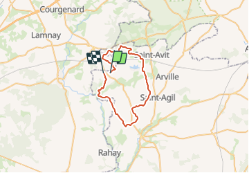
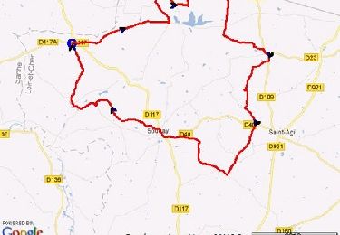
Trail Mountain bike of 38 km to be discovered at Centre-Loire Valley, Loir-et-Cher, Couëtron-au-Perche. This trail is proposed by tracegps.
Description
Boucle au départ de Chevrotin puis en lisière de la forêt de Montmirail autour de le Plessy Dorin par le GR de Pays avant le retour par le chemin de la Vallée du Loir.
Positioning
Country:
France
Region :
Centre-Loire Valley
Department/Province :
Loir-et-Cher
Municipality :
Couëtron-au-Perche
Location:
Souday
Start:(Dec)
Start:(UTM)
338627 ; 5326029 (31U) N.
Comments
Trails nearby
![Trail Mountain bike Couëtron-au-Perche - Boucle VTT à Souday - Photo](https://media.geolcdn.com/t/375/260/ext.jpg?maxdim=2&url=https%3A%2F%2Fservices.sitytrail.com%2FGeolivesWS%2FDownloadMedia.ashx%3FTrailID%3D118807%26Media%3D13015_1.jpg)
![Mountain bike Mountain bike](https://static1.geolcdn.com/sitytour/trail-icons/202.png)
Boucle VTT à Souday
Mountain bike
Difficult
Couëtron-au-Perche,
Centre-Loire Valley,
Loir-et-Cher,
France
![](/images/other/stat-length.png)
30 km | 34 km-effort
2h 0min
![](https://static1.geolcdn.com/siteimages/upload/files/16400158638029165_repeat_loop_refresh_sync_direction_icon.png)
Yes
![Trail Walking Montmirail - Chemins autour de Montmirail - Photo](https://media.geolcdn.com/t/375/260/ext.jpg?maxdim=2&url=https%3A%2F%2Fservices.sitytrail.com%2FGeolivesWS%2FDownloadMedia.ashx%3FTrailID%3D102026%26Media%3D2347_1.jpg)
![Walking Walking](https://static1.geolcdn.com/sitytour/trail-icons/101.png)
Chemins autour de Montmirail
Walking
Medium
Montmirail,
Pays de la Loire,
Sarthe,
France
![](/images/other/stat-length.png)
10.5 km | 12.7 km-effort
2h 0min
![](https://static1.geolcdn.com/siteimages/upload/files/16400158638029165_repeat_loop_refresh_sync_direction_icon.png)
Yes
![Walking Walking](https://static1.geolcdn.com/sitytour/trail-icons/101.png)
Montmirail
Walking
Difficult
Montmirail,
Pays de la Loire,
Sarthe,
France
![](/images/other/stat-length.png)
10.3 km | 12.4 km-effort
2h 48min
![](https://static1.geolcdn.com/siteimages/upload/files/16400158638029165_repeat_loop_refresh_sync_direction_icon.png)
Yes
![Trail Walking Le Plessis-Dorin - plessis dorin 16.6 - Photo](https://media.geolcdn.com/t/375/260/ext.jpg?maxdim=2&url=https%3A%2F%2Fstatic1.geolcdn.com%2Fsiteimages%2Fupload%2Ffiles%2F1553511878bg_sport_marche.png)
![Walking Walking](https://static1.geolcdn.com/sitytour/trail-icons/101.png)
plessis dorin 16.6
Walking
Very easy
Le Plessis-Dorin,
Centre-Loire Valley,
Loir-et-Cher,
France
![](/images/other/stat-length.png)
16.2 km | 19.5 km-effort
4h 6min
![](https://static1.geolcdn.com/siteimages/upload/files/16400158638029165_repeat_loop_refresh_sync_direction_icon.png)
Yes
![Trail Walking Couëtron-au-Perche - Souday - Photo](https://media.geolcdn.com/t/375/260/ext.jpg?maxdim=2&url=https%3A%2F%2Fstatic1.geolcdn.com%2Fsiteimages%2Fupload%2Ffiles%2F1553511878bg_sport_marche.png)
![Walking Walking](https://static1.geolcdn.com/sitytour/trail-icons/101.png)
Souday
Walking
Easy
Couëtron-au-Perche,
Centre-Loire Valley,
Loir-et-Cher,
France
![](/images/other/stat-length.png)
18.4 km | 21 km-effort
6h 16min
![](https://static1.geolcdn.com/siteimages/upload/files/16400158638029165_repeat_loop_refresh_sync_direction_icon.png)
Yes
![Trail Walking Melleray - Melleray 15 - Photo](https://media.geolcdn.com/t/375/260/ext.jpg?maxdim=2&url=https%3A%2F%2Fstatic1.geolcdn.com%2Fsiteimages%2Fupload%2Ffiles%2F1553511878bg_sport_marche.png)
![Walking Walking](https://static1.geolcdn.com/sitytour/trail-icons/101.png)
Melleray 15
Walking
Medium
Melleray,
Pays de la Loire,
Sarthe,
France
![](/images/other/stat-length.png)
15.9 km | 19.2 km-effort
4h 10min
![](https://static1.geolcdn.com/siteimages/upload/files/16400158638029165_repeat_loop_refresh_sync_direction_icon.png)
Yes
![Trail Walking Couëtron-au-Perche - Souday le Plessis Dorin - Photo](https://media.geolcdn.com/t/375/260/ext.jpg?maxdim=2&url=https%3A%2F%2Fstatic1.geolcdn.com%2Fsiteimages%2Fupload%2Ffiles%2F1553511878bg_sport_marche.png)
![Walking Walking](https://static1.geolcdn.com/sitytour/trail-icons/101.png)
Souday le Plessis Dorin
Walking
Medium
Couëtron-au-Perche,
Centre-Loire Valley,
Loir-et-Cher,
France
![](/images/other/stat-length.png)
24 km | 28 km-effort
6h 10min
![](https://static1.geolcdn.com/siteimages/upload/files/16400158638029165_repeat_loop_refresh_sync_direction_icon.png)
Yes