![](/images/other/stat-length.png)
![Trail Mountain bike Coteaux du Lizon - Cuttura - Prés de la Rixouse - Photo](https://media.geolcdn.com/t/1900/400/ext.pjpeg?maxdim=2&url=https%3A%2F%2Fservices.sitytrail.com%2FGeolivesWS%2FDownloadMedia.ashx%3FTrailID%3D106472%26Media%3D10991_1.jpg)
Cuttura - Prés de la Rixouse
tracegps
User
![Length](/images/other/stat-length.png)
![Max alt](https://static1.geolcdn.com/siteimages/upload/files/1508320355ic_sort_altitude_max_24dp.png)
![Uphill gradient](https://static1.geolcdn.com/siteimages/upload/files/1508320355ic_sort_den_pos_24dp.png)
![Km-Effort](/images/other/stat-length.png)
![Min alt](https://static1.geolcdn.com/siteimages/upload/files/1508320355ic_sort_altitude_min_24dp.png)
![Downhill gradient](https://static1.geolcdn.com/siteimages/upload/files/1508320355ic_sort_den_neg_24dp.png)
![Boucle](https://static1.geolcdn.com/siteimages/upload/files/16400158638029165_repeat_loop_refresh_sync_direction_icon.png)
![Mountain bike](https://static1.geolcdn.com/sitytour/trail-icons/202.png)
2h30
Difficulty : Medium
![Scan this QR Code to open this trail in the SityTrail application](https://capi.geolives.com/qq0zvz2zws4bq2lad0pu/sitytour/trails/106472/qr.png?size=200)
FREE GPS app for hiking
About
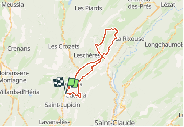
Trail Mountain bike of 24 km to be discovered at Bourgogne-Franche-Comté, Jura, Coteaux du Lizon. This trail is proposed by tracegps.
Description
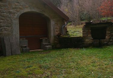
Départ: parking du lac de Cuttura. Itinéraire conseillé dans le sens: Lac de Cuttura -> Vichaumois -> Sur la Côte -> Les Prés de la Rixouse -> Les Prés de Valfin -> Sur la Côte -> Les Saumoires -> Cuttura - Lac de Cuttura. Attention: il est nécessaire de prendre une petite route en sens interdit sur 800m (à partir du Km 2) la prudence s'impose en roulant le plus possible sur le bas coté droit. Intérêts: table d'orientation de "Sur la Côte", éventuellement petit détour au belvédère du Capet. La difficulté de ce parcours est essentiellement la montée jusqu'à "sur la Côte". Ensuite, encore quelque montées mais pas très longues. Le retour depuis "Sur la Côte" jusqu'à "Cuttura" est essentiellement descendant et offre un tracé très ludique.
Positioning
Comments
Trails nearby
![Trail Walking Saint-Claude - Belvd. Pontoux depuis Rue des Perrieres à St-Claude 39200 - Photo](https://media.geolcdn.com/t/375/260/f9b19760-1bb3-48d6-b56c-4ed1797baa03.jpg&format=jpg&maxdim=2)
![Walking Walking](https://static1.geolcdn.com/sitytour/trail-icons/101.png)
Walking
![](/images/other/stat-length.png)
![](https://static1.geolcdn.com/siteimages/upload/files/16400158638029165_repeat_loop_refresh_sync_direction_icon.png)
![Trail Walking Saint-Claude - St Claude Cascade de la Vouivre - Photo](https://media.geolcdn.com/t/375/260/223568e4-ca44-4832-866a-614785810ad8.jpg&format=jpg&maxdim=2)
![Walking Walking](https://static1.geolcdn.com/sitytour/trail-icons/101.png)
Walking
![](/images/other/stat-length.png)
![](https://static1.geolcdn.com/siteimages/upload/files/16400158638029165_repeat_loop_refresh_sync_direction_icon.png)
![Trail On foot Coteaux du Lizon - Sentier des savoir-faire - Photo](https://media.geolcdn.com/t/375/260/5e891745-52e2-4c86-82b9-36da00a76ac0.jpeg&format=jpg&maxdim=2)
![On foot On foot](https://static1.geolcdn.com/sitytour/trail-icons/100.png)
On foot
![](/images/other/stat-length.png)
![](https://static1.geolcdn.com/siteimages/upload/files/16400158638029165_repeat_loop_refresh_sync_direction_icon.png)
![Trail Walking Saint-Claude - De St-Claude à Vaucluse - Photo](https://media.geolcdn.com/t/375/260/6f07c1ae-93f7-4e21-bedc-a3f02b9c3c40.jpg&format=jpg&maxdim=2)
![Walking Walking](https://static1.geolcdn.com/sitytour/trail-icons/101.png)
Walking
![](/images/other/stat-length.png)
![](https://static1.geolcdn.com/siteimages/upload/files/16400158638029165_repeat_loop_refresh_sync_direction_icon.png)
![Trail Walking Saint-Claude - les Prés de Valfin - Photo](https://media.geolcdn.com/t/375/260/ext.jpg?maxdim=2&url=https%3A%2F%2Fstatic1.geolcdn.com%2Fsiteimages%2Fupload%2Ffiles%2F1553511878bg_sport_marche.png)
![Walking Walking](https://static1.geolcdn.com/sitytour/trail-icons/101.png)
Walking
![](/images/other/stat-length.png)
![](https://static1.geolcdn.com/siteimages/upload/files/16400158638029165_repeat_loop_refresh_sync_direction_icon.png)
![Trail Walking Coteaux du Lizon - Vallée du Lison - Photo](https://media.geolcdn.com/t/375/260/ext.jpg?maxdim=2&url=https%3A%2F%2Fstatic1.geolcdn.com%2Fsiteimages%2Fupload%2Ffiles%2F1553511878bg_sport_marche.png)
![Walking Walking](https://static1.geolcdn.com/sitytour/trail-icons/101.png)
Walking
![](/images/other/stat-length.png)
![](https://static1.geolcdn.com/siteimages/upload/files/16400158638029165_repeat_loop_refresh_sync_direction_icon.png)
![Trail Walking Coteaux du Lizon - gorges du Lison . départ de Saint lupicin - Photo](https://media.geolcdn.com/t/375/260/286e2e3c-117d-4fdc-a219-2e81e971f03b.jpg&format=jpg&maxdim=2)
![Walking Walking](https://static1.geolcdn.com/sitytour/trail-icons/101.png)
Walking
![](/images/other/stat-length.png)
![](https://static1.geolcdn.com/siteimages/upload/files/16400158638029165_repeat_loop_refresh_sync_direction_icon.png)
![Trail Walking Villards-d'Héria - lac d'Antre Belvédère de Scia - Photo](https://media.geolcdn.com/t/375/260/6cd2b4bc-9d84-4485-b770-90954281a052.jpg&format=jpg&maxdim=2)
![Walking Walking](https://static1.geolcdn.com/sitytour/trail-icons/101.png)
Walking
![](/images/other/stat-length.png)
![](https://static1.geolcdn.com/siteimages/upload/files/16400158638029165_repeat_loop_refresh_sync_direction_icon.png)
![Trail Walking Villards-d'Héria - lac d antre - Photo](https://media.geolcdn.com/t/375/260/80be7616-6067-46a5-8c84-8aeff2838ece.jpg&format=jpg&maxdim=2)
![Walking Walking](https://static1.geolcdn.com/sitytour/trail-icons/101.png)
Walking
![](/images/other/stat-length.png)
![](https://static1.geolcdn.com/siteimages/upload/files/16400158638029165_repeat_loop_refresh_sync_direction_icon.png)