![](/images/other/stat-length.png)
![Trail Mountain bike Hyères - Site VTT FFC Hyères - les Îles d'Or - Tour des Borrels - Photo](https://media.geolcdn.com/t/1900/400/ext.pjpeg?maxdim=2&url=https%3A%2F%2Fservices.sitytrail.com%2FGeolivesWS%2FDownloadMedia.ashx%3FTrailID%3D106440%26Media%3D10947_1.jpg)
Site VTT FFC Hyères - les Îles d'Or - Tour des Borrels
tracegps
User
![Length](/images/other/stat-length.png)
![Max alt](https://static1.geolcdn.com/siteimages/upload/files/1508320355ic_sort_altitude_max_24dp.png)
![Uphill gradient](https://static1.geolcdn.com/siteimages/upload/files/1508320355ic_sort_den_pos_24dp.png)
![Km-Effort](/images/other/stat-length.png)
![Min alt](https://static1.geolcdn.com/siteimages/upload/files/1508320355ic_sort_altitude_min_24dp.png)
![Downhill gradient](https://static1.geolcdn.com/siteimages/upload/files/1508320355ic_sort_den_neg_24dp.png)
![Boucle](https://static1.geolcdn.com/siteimages/upload/files/16400158638029165_repeat_loop_refresh_sync_direction_icon.png)
![Mountain bike](https://static1.geolcdn.com/sitytour/trail-icons/202.png)
2h30
Difficulty : Difficult
![Scan this QR Code to open this trail in the SityTrail application](https://capi.geolives.com/qq0zvz2zws4bq2lad0pu/sitytour/trails/106440/qr.png?size=200)
FREE GPS app for hiking
About
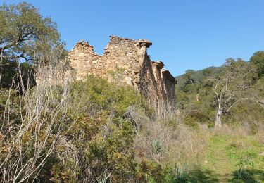
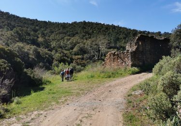
Trail Mountain bike of 17.7 km to be discovered at Provence-Alpes-Côte d'Azur, Var, Hyères. This trail is proposed by tracegps.
Description
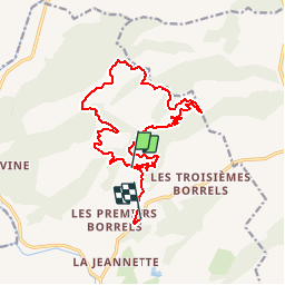
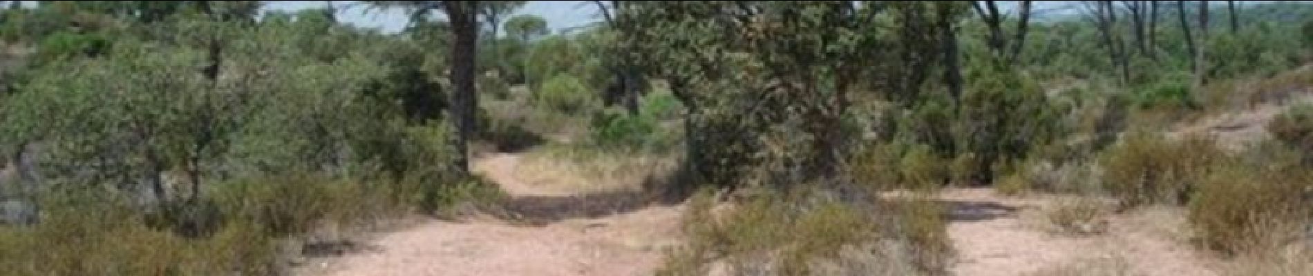
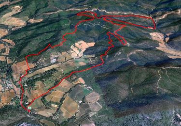
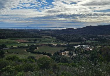
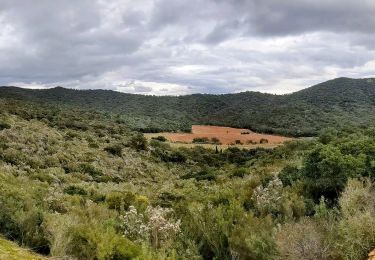
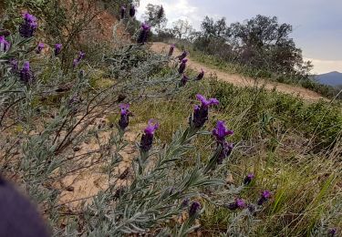
Site VTT FFC Hyères - les Îles d’Or - Tour des Borrels. Circuit officiel labellisé par la Fédération Française de Cyclisme. • Couleur de parcours : Rouge (difficile) • Distance : 19 km • Dénivelé positif : 700 m • Départ du parking du Crapa des Borrels. Descriptif : Au départ du parking du Crapa des Borrels on part sur une petite portion de route goudronnée sur environ 200 m pour tourner à droite et récupérer la piste de la Baisse des Contes. Circuit long de 19 km avec un dénivelé positif très important. Cette randonnée est réservée aux pratiquants habitués aux efforts longs et aimant surtout les longues ascensions sur des pistes larges ou l’on peut prendre beaucoup de vitesse et mettre du braquet. Le retour sur le village des Borrels est descendant, mais attention il faudra aussi pédaler car on rencontrera souvent de petits faux plats montants. Au point culminant du circuit on aura une magnifique vue sur la forêt du massif des Maures, très chère à la célébrité locale « Maurin des Maures ».
Positioning
Comments
Trails nearby
![Trail Walking La Londe-les-Maures - SityTrail - Notre Dame des Maures-12-02-21 - Photo](https://media.geolcdn.com/t/375/260/0b9959c2-5f7c-4a9a-9278-b73c6a0d11e2.jpg&format=jpg&maxdim=2)
![Walking Walking](https://static1.geolcdn.com/sitytour/trail-icons/101.png)
Walking
![](/images/other/stat-length.png)
![](https://static1.geolcdn.com/siteimages/upload/files/16400158638029165_repeat_loop_refresh_sync_direction_icon.png)
![Trail Walking La Londe-les-Maures - Dolmen de Gaoutabry et balade dans les Maures - Photo](https://media.geolcdn.com/t/375/260/f1004697-bd1c-4c2b-9ec9-2754fa4b3e4c.jpg&format=jpg&maxdim=2)
![Walking Walking](https://static1.geolcdn.com/sitytour/trail-icons/101.png)
Walking
![](/images/other/stat-length.png)
![](https://static1.geolcdn.com/siteimages/upload/files/16400158638029165_repeat_loop_refresh_sync_direction_icon.png)
![Trail Walking La Londe-les-Maures - boucle au pas du cerf - Photo](https://media.geolcdn.com/t/375/260/22f13272-a11e-4f2b-b259-ab83ecd6f72d.jpg&format=jpg&maxdim=2)
![Walking Walking](https://static1.geolcdn.com/sitytour/trail-icons/101.png)
Walking
![](/images/other/stat-length.png)
![](https://static1.geolcdn.com/siteimages/upload/files/16400158638029165_repeat_loop_refresh_sync_direction_icon.png)
![Trail Walking La Crau - la navarre 3 - Photo](https://media.geolcdn.com/t/375/260/9d287709-14c0-49e0-b7ea-0c5e58c58fd2.jpg&format=jpg&maxdim=2)
![Walking Walking](https://static1.geolcdn.com/sitytour/trail-icons/101.png)
Walking
![](/images/other/stat-length.png)
![](https://static1.geolcdn.com/siteimages/upload/files/16400158638029165_repeat_loop_refresh_sync_direction_icon.png)
![Trail Walking La Crau - La Navarre - Photo](https://media.geolcdn.com/t/375/260/324326e5-fc90-4ffb-ad39-599324ef28a6.jpg&format=jpg&maxdim=2)
![Walking Walking](https://static1.geolcdn.com/sitytour/trail-icons/101.png)
Walking
![](/images/other/stat-length.png)
![](https://static1.geolcdn.com/siteimages/upload/files/16400158638029165_repeat_loop_refresh_sync_direction_icon.png)
![Trail Walking La Londe-les-Maures - La LONDE DOLMEN GAUTABRY - Photo](https://media.geolcdn.com/t/375/260/a97f7fdf-f5c1-4f54-b5b7-9fb7d78f65c6.jpg&format=jpg&maxdim=2)
![Walking Walking](https://static1.geolcdn.com/sitytour/trail-icons/101.png)
Walking
![](/images/other/stat-length.png)
![](https://static1.geolcdn.com/siteimages/upload/files/16400158638029165_repeat_loop_refresh_sync_direction_icon.png)
![Trail Walking Hyères - Les Borels 2 VTT - Photo](https://media.geolcdn.com/t/375/260/6cb77d4b-2e3d-49b3-b6ba-9c8faa89e408.jpg&format=jpg&maxdim=2)
![Walking Walking](https://static1.geolcdn.com/sitytour/trail-icons/101.png)
Walking
![](/images/other/stat-length.png)
![](https://static1.geolcdn.com/siteimages/upload/files/16400158638029165_repeat_loop_refresh_sync_direction_icon.png)
![Trail Walking La Londe-les-Maures - gaoutabry - Photo](https://media.geolcdn.com/t/375/260/38b30efd-9345-42c5-ba31-48ae41d6a52f.jpg&format=jpg&maxdim=2)
![Walking Walking](https://static1.geolcdn.com/sitytour/trail-icons/101.png)
Walking
![](/images/other/stat-length.png)
![](https://static1.geolcdn.com/siteimages/upload/files/16400158638029165_repeat_loop_refresh_sync_direction_icon.png)
![Trail Walking Hyères - Boucle au dessus des Borrels - Photo](https://media.geolcdn.com/t/375/260/bb3fd077-0919-4546-bed4-7c3cd8c34573.jpg&format=jpg&maxdim=2)
![Walking Walking](https://static1.geolcdn.com/sitytour/trail-icons/101.png)
Walking
![](/images/other/stat-length.png)
![](https://static1.geolcdn.com/siteimages/upload/files/16400158638029165_repeat_loop_refresh_sync_direction_icon.png)