Trail Mountain bike Hyères - Site VTT FFC Hyères - les Îles d'Or - La Jean Marc   - Photo

Site VTT FFC Hyères - les Îles d'Or - La Jean Marc

 tracegps
tracegps

User

© OpenStreetMap contributors
Length
Length
3 km
Max alt
Max alt
184 m
Uphill gradient
Uphill gradient
121 m
Km-Effort
Km-Effort  
4.6 km
Min alt
Min alt
70 m
Downhill gradient
Downhill gradient
117 m
Boucle
Boucle
Yes
Creation date :
2014-12-10 00:00:00.0
Updated on :
2014-12-10 00:00:00.0

(0 Reviews)

Mountain bike
Mountain bike
30m
Difficulty : Difficult

Scan this QR Code to open this trail in the SityTrail application

FREE GPS app for hiking

Logo SityTrail SityTrail

IGN / Geographical institutes

Download SityTrail from the App Store Download SityTrail from Google Play

Logo SityTrail SityTrail World

The world is yours!

Download SityTrail from the App Store Download SityTrail from Google Play Download SityTrail on Huawei AppGallery

About

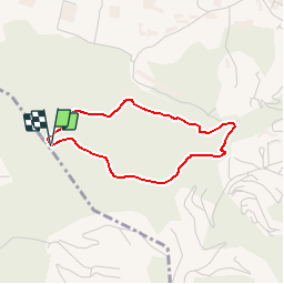
Trail Mountain bike of 3 km to be discovered at Provence-Alpes-Côte d'Azur, Var, Hyères. This trail is proposed by tracegps.

Description

Site VTT FFC Hyères - les Îles d’Or - La Jean Marc. Circuit officiel labellisé par la Fédération Française de Cyclisme. • Couleur de parcours : Rouge (difficile) • Distance : 3,100 km si départ parking stand de tir, si départ vélodrome liaison de 1,6 km. • Dénivelé positif : 144 m • Départ du parking stand de tir ou parking vélodrome Toulon Provence Méditerranée. Descriptif : Circuit pour les pratiquants de l’enduro qui emprunte une ascension accessible sur une piste large mais rendue technique sur la partie finale due aux nombreux cailloux. La descente est technique avec de nombreux sauts fossés, marches en pierres, petites restanques…Pour chaque saut des échappatoires ont été aménagés afin de la rendre accessible à un plus grand nombre de vététistes. Descente technique ou l’on peut prendre beaucoup de vitesse, attention à bien maîtriser sa technique et sa vitesse.

Elevation profile

Photos

Positioning

Country:
France
Region :
Provence-Alpes-Côte d'Azur
Department/Province :
Var
Municipality :
Hyères
Location:
Unknown
Start:(Dec)
Start:(UTM)
263801 ; 4776263 (32T) N.

Trails nearby

Trail Walking La Crau - Le Paradis et le mont des oiseaux - Photo
Walking
GUIDE
affinetataille

Walking

Medium
(1)
La Crau, Provence-Alpes-Côte d'Azur, Var, France
12.5 km | 19.9 km-effort
6h 30min
Yes
Trail Walking La Crau - fenouillet Daniel Louis - Photo
Walking
cdanielrando

Walking

Medium
(1)
La Crau, Provence-Alpes-Côte d'Azur, Var, France
18.1 km | 25 km-effort
4h 36min
Yes
Trail Walking La Crau - le fenouillet un après-midi d'automne  - Photo
Walking
le.noceur

Walking

Easy
(2)
La Crau, Provence-Alpes-Côte d'Azur, Var, France
7.6 km | 10.7 km-effort
1h 48min
Yes
Trail Trail La Crau - Le Fenouillet et château d' Hyères  - Photo
Trail
GUIDE
nadd73

Trail

Medium
La Crau, Provence-Alpes-Côte d'Azur, Var, France
13.1 km | 18.8 km-effort
2h 9min
No
Trail Walking La Crau - Fenouillet - Chateau de Hyères - retour par les vignes - Photo
Walking
GUIDE
affinetataille

Walking

Medium
(2)
La Crau, Provence-Alpes-Côte d'Azur, Var, France
14.1 km | 19.7 km-effort
5h 0min
Yes
Trail Walking Hyères - La Capte Tour fondue - Photo
Walking
Marchopier

Walking

Easy
Hyères, Provence-Alpes-Côte d'Azur, Var, France
14.6 km | 17.2 km-effort
4h 50min
Yes
Trail Walking La Crau - fenouillet plan du pont - Photo
Walking
cdanielrando

Walking

Very difficult
La Crau, Provence-Alpes-Côte d'Azur, Var, France
16.2 km | 24 km-effort
5h 24min
Yes
Trail Walking Carqueiranne - la grotte du paradis  - Photo
Walking
cdanielrando

Walking

Easy
(1)
Carqueiranne, Provence-Alpes-Côte d'Azur, Var, France
3.9 km | 6.6 km-effort
1h 35min
Yes
Trail Walking Hyères - Ayguade plage port - Photo
Walking
001659.1362f64359af4990b089f4e6d026b710.1503

Walking

Easy
Hyères, Provence-Alpes-Côte d'Azur, Var, France
13.4 km | 14.7 km-effort
2h 32min
Yes


Close
My subscriptions