Trail Snowshoes Stosswihr - Crêtes des Vosges en hiver - De Schallern à Steinlebach - Photo

Crêtes des Vosges en hiver - De Schallern à Steinlebach

 tracegps
tracegps

User

© OpenStreetMap contributors
Length
Length
24 km
Max alt
Max alt
1268 m
Uphill gradient
Uphill gradient
879 m
Km-Effort
Km-Effort  
35 km
Min alt
Min alt
798 m
Downhill gradient
Downhill gradient
833 m
Boucle
Boucle
No
Creation date :
2014-12-10 00:00:00.0
Updated on :
2014-12-10 00:00:00.0

(0 Reviews)

Snowshoes
Snowshoes
8h00
Difficulty : Difficult

Scan this QR Code to open this trail in the SityTrail application

FREE GPS app for hiking

Logo SityTrail SityTrail

IGN / Geographical institutes

Download SityTrail from the App Store Download SityTrail from Google Play

Logo SityTrail SityTrail World

The world is yours!

Download SityTrail from the App Store Download SityTrail from Google Play Download SityTrail on Huawei AppGallery

About

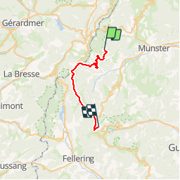
Trail Snowshoes of 24 km to be discovered at Grand Est, Haut-Rhin, Stosswihr. This trail is proposed by tracegps.

Description

Étape 4 - Crêtes des Vosges en hiver – De Schallern à Steinlebach Partir tôt (essayer de négocier l'heure du petit-déjeuner) car l'étape est longue surtout si l'on marche avec les raquettes. On descend par le sentier triangle bleu à la station du Gaschney pour prendre ensuite le sentier rectangle bleu jusqu'au lac de la Schiessrothried. Rejoindre le lac du Fischboedele par le sentier rectangle rouge (GR5). Au lac du Fischboedele, prendre le sentier balisé croix bleue qui monte à Kerbholz et continuer sur le sentier rectangle bleu jusqu'à Fermuss et refuge du Rainkopf... La suite du récit est ICI.

Elevation profile

Photos

Positioning

Country:
France
Region :
Grand Est
Department/Province :
Haut-Rhin
Municipality :
Stosswihr
Location:
Unknown
Start:(UTM)
353911 ; 5322317 (32U) N.

Trails nearby

Trail Walking La Bresse - 2023-04-16 Marche Abri Lac de Blanchemer vers Lac de Lispach - Photo
Walking
GUIDE
holtzv

Walking

Very difficult
(1)
La Bresse, Grand Est, Vosges, France
23 km | 36 km-effort
8h 4min
No
Trail Walking Le Valtin - Les Rochers des Hirschsteine - Lac Vert - Photo
Walking
GUIDE
Michel1963

Walking

Difficult
(2)
Le Valtin, Grand Est, Vosges, France
14.4 km | 22 km-effort
5h 2min
Yes
Trail Walking Le Valtin - Le Sentier des Roches - Photo
Walking
GUIDE
Michel1963

Walking

Difficult
(2)
Le Valtin, Grand Est, Vosges, France
20 km | 34 km-effort
7h 43min
Yes
Trail Walking Stosswihr - Tour du belvedere avec le passage sur les crêtes  - Photo
Walking
ocepee

Walking

Very easy
(2)
Stosswihr, Grand Est, Haut-Rhin, France
8.5 km | 0 m-effort
2h 28min
Yes
Trail Walking La Bresse - Kastelberg des pierres, des lacs, des panoramas magnifiques  - Photo
Walking
Alfredy

Walking

Difficult
(1)
La Bresse, Grand Est, Vosges, France
15.1 km | 26 km-effort
6h 11min
Yes
Trail Walking La Bresse - Les 5 lacs autour du Hohneck - Photo
Walking
tiene

Walking

Very difficult
(1)
La Bresse, Grand Est, Vosges, France
21 km | 36 km-effort
7h 21min
Yes
Trail Walking Le Valtin - Les Hirschsteine - Photo
Walking
VacheKiri67

Walking

Difficult
(1)
Le Valtin, Grand Est, Vosges, France
16.1 km | 25 km-effort
6h 28min
Yes
Trail Walking La Bresse - Du Hohneck au Kastelberg par les Spietzkoepfe et le Sentier des Névées - Photo
Walking
tracegps

Walking

Very difficult
(3)
La Bresse, Grand Est, Vosges, France
7.6 km | 13.7 km-effort
3h 30min
Yes
Trail Walking La Bresse - Rainkopf - Mittlach - Hohneck - Photo
Walking
tracegps

Walking

Difficult
(1)
La Bresse, Grand Est, Vosges, France
22 km | 41 km-effort
8h 0min
Yes


Close
My subscriptions