Trail Walking Bassuet - Circuit de Bassuet. - Photo

Circuit de Bassuet.

 tracegps
tracegps

User

© OpenStreetMap contributors
Length
Length
14 km
Max alt
Max alt
230 m
Uphill gradient
Uphill gradient
210 m
Km-Effort
Km-Effort  
16.8 km
Min alt
Min alt
123 m
Downhill gradient
Downhill gradient
210 m
Boucle
Boucle
Yes
Creation date :
2014-12-10 00:00:00.0
Updated on :
2014-12-10 00:00:00.0

(0 Reviews)

Walking
Walking
3h30
Difficulty : Difficult

Scan this QR Code to open this trail in the SityTrail application

FREE GPS app for hiking

Logo SityTrail SityTrail

IGN / Geographical institutes

Download SityTrail from the App Store Download SityTrail from Google Play

Logo SityTrail SityTrail World

The world is yours!

Download SityTrail from the App Store Download SityTrail from Google Play Download SityTrail on Huawei AppGallery

About

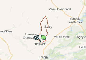
Trail Walking of 14 km to be discovered at Grand Est, Marne, Bassuet. This trail is proposed by tracegps.

Description

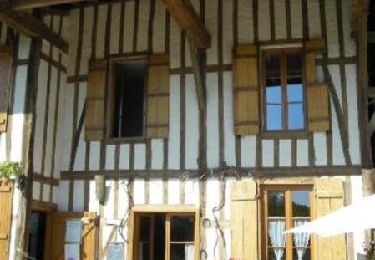
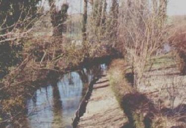
Circuit proposé par l'Association Promouvoir Saint Amand et la Vallée du Fion afin de vous faire découvrir cette magnifique vallée à l’habitat traditionnel « à pans de bois ». Départ du village de Bassuet. Retrouvez le plan et le descriptif du circuit à la rubrique documentation sur « le site de l'auteur ».

Elevation profile

Photos

Positioning

Country:
France
Region :
Grand Est
Department/Province :
Marne
Municipality :
Bassuet
Location:
Unknown
Start:(UTM)
622651 ; 5406659 (31U) N.

Trails nearby

Trail Walking Saint-Amand-sur-Fion - Circuit des éoliennes  16kms - St-Amand-sur-Fion - Photo
Walking
tracegps

Walking

Difficult
Saint-Amand-sur-Fion, Grand Est, Marne, France
16 km | 19.7 km-effort
4h 0min
Yes
Trail Walking Saint-Amand-sur-Fion - Circuit des éoliennes 10 kms - St-Amand-sur-Fion - Photo
Walking
tracegps

Walking

Medium
(1)
Saint-Amand-sur-Fion, Grand Est, Marne, France
10.1 km | 12.5 km-effort
2h 30min
Yes
Trail Walking Saint-Amand-sur-Fion - Circuit de St-Amand-sur-Fion  - Photo
Walking
tracegps

Walking

Difficult
Saint-Amand-sur-Fion, Grand Est, Marne, France
15.8 km | 19.6 km-effort
4h 0min
Yes
Trail On foot Vitry-en-Perthois - Circuit du Mont de Fourche - Photo
On foot
GUIDE+

On foot

Easy
Vitry-en-Perthois, Grand Est, Marne, France
5 km | 6 km-effort
1h 21min
No
Trail Walking Val-de-Vière - Boucle à travers les vignes - Val de Vière - Photo
Walking
tracegps

Walking

Easy
Val-de-Vière, Grand Est, Marne, France
6.9 km | 8.8 km-effort
1h 45min
Yes
Trail Walking Changy - Changy 08-04-2014 - Photo
Walking
JD51290

Walking

Very easy
Changy, Grand Est, Marne, France
11.5 km | 13.1 km-effort
2h 49min
Yes
Trail Walking Outrepont - Outrepont 03/04/2014 - Photo
Walking
JD51290

Walking

Very easy
Outrepont, Grand Est, Marne, France
12.1 km | 12.6 km-effort
2h 56min
Yes


Close
My subscriptions