![](/images/other/stat-length.png)
![Trail Mountain bike Le Havre - Le Havre Montgeon - Fontaine - Rouelle - Le Havre Montgeon - Photo](https://media.geolcdn.com/t/1900/400/ext.pjpeg?maxdim=2&url=https%3A%2F%2Fservices.sitytrail.com%2FGeolivesWS%2FDownloadMedia.ashx%3FTrailID%3D106334%26Media%3D10788_4.jpg)
Le Havre Montgeon - Fontaine - Rouelle - Le Havre Montgeon
tracegps
User
![Length](/images/other/stat-length.png)
Length
14.2 km
![Max alt](https://static1.geolcdn.com/siteimages/upload/files/1508320355ic_sort_altitude_max_24dp.png)
Max alt
90 m
![Uphill gradient](https://static1.geolcdn.com/siteimages/upload/files/1508320355ic_sort_den_pos_24dp.png)
Uphill gradient
239 m
![Km-Effort](/images/other/stat-length.png)
Km-Effort
17.4 km
![Min alt](https://static1.geolcdn.com/siteimages/upload/files/1508320355ic_sort_altitude_min_24dp.png)
Min alt
14 m
![Downhill gradient](https://static1.geolcdn.com/siteimages/upload/files/1508320355ic_sort_den_neg_24dp.png)
Downhill gradient
241 m
![Boucle](https://static1.geolcdn.com/siteimages/upload/files/16400158638029165_repeat_loop_refresh_sync_direction_icon.png)
Boucle
Yes
Creation date :
2014-12-10 00:00:00.0
Updated on :
2014-12-10 00:00:00.0
![Mountain bike](https://static1.geolcdn.com/sitytour/trail-icons/202.png)
1h19
Difficulty : Medium
![Scan this QR Code to open this trail in the SityTrail application](https://capi.geolives.com/qq0zvz2zws4bq2lad0pu/sitytour/trails/106334/qr.png?size=200)
FREE GPS app for hiking
About
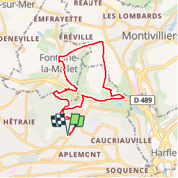
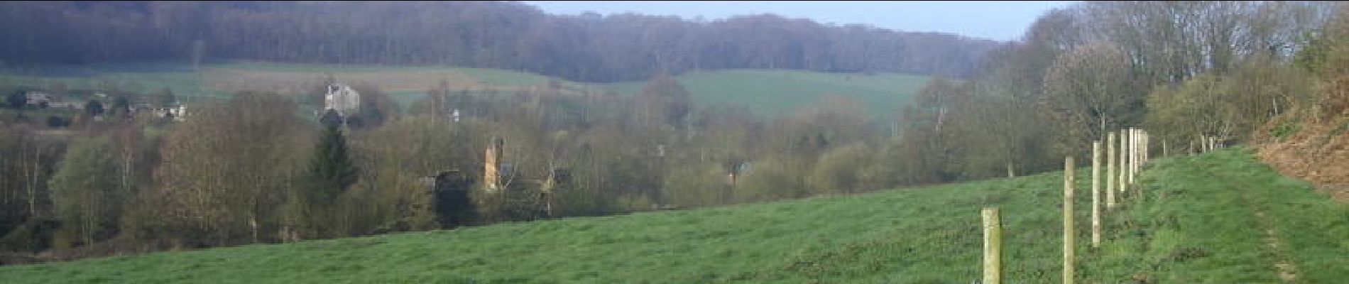
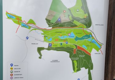
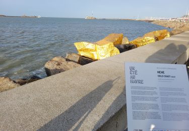
Trail Mountain bike of 14.2 km to be discovered at Normandy, Seine-Maritime, Le Havre. This trail is proposed by tracegps.
Description
Bonjour à tous. Fraicheur matinale et soleil pour ce circuit VTT qui m'a bien réveillé. Il y a des bonnes montées, il ne faut pas lâcher. Bonne balade !
Positioning
Country:
France
Region :
Normandy
Department/Province :
Seine-Maritime
Municipality :
Le Havre
Location:
Unknown
Start:(Dec)
Start:(UTM)
293744 ; 5488376 (31U) N.
Comments
Trails nearby
![Trail Walking Harfleur - Turner's walk - Photo](https://media.geolcdn.com/t/375/260/ext.jpg?maxdim=2&url=https%3A%2F%2Fservices.sitytrail.com%2FGeolivesWS%2FDownloadMedia.ashx%3FTrailID%3D338140%26Media%3D38869f3e-a905-416b-990a-9713f7dd7e14.jpg)
![Walking Walking](https://static1.geolcdn.com/sitytour/trail-icons/101.png)
Turner's walk
Walking
Easy
(1)
Harfleur,
Normandy,
Seine-Maritime,
France
![](/images/other/stat-length.png)
7.7 km | 9.1 km-effort
3h 0min
![](https://static1.geolcdn.com/siteimages/upload/files/16400158638029165_repeat_loop_refresh_sync_direction_icon.png)
Yes
![Trail Walking Le Havre - Découvrir Le Havre - Photo](https://media.geolcdn.com/t/375/260/ext.jpg?maxdim=2&url=https%3A%2F%2Fservices.sitytrail.com%2FGeolivesWS%2FDownloadMedia.ashx%3FTrailID%3D173067%26Media%3D14597_6.jpg)
![Walking Walking](https://static1.geolcdn.com/sitytour/trail-icons/101.png)
Découvrir Le Havre
Walking
Difficult
(1)
Le Havre,
Normandy,
Seine-Maritime,
France
![](/images/other/stat-length.png)
14.2 km | 17 km-effort
3h 30min
![](https://static1.geolcdn.com/siteimages/upload/files/16400158638029165_repeat_loop_refresh_sync_direction_icon.png)
Yes
![Trail On foot Fontaine-la-Mallet - Les Bassins des Vallées - Photo](https://media.geolcdn.com/t/375/260/ce57ffe6-f4ea-486c-bc79-47861158f9a7.jpeg&format=jpg&maxdim=2)
![On foot On foot](https://static1.geolcdn.com/sitytour/trail-icons/100.png)
Les Bassins des Vallées
On foot
Easy
Fontaine-la-Mallet,
Normandy,
Seine-Maritime,
France
![](/images/other/stat-length.png)
5.1 km | 6 km-effort
1h 21min
![](https://static1.geolcdn.com/siteimages/upload/files/16400158638029165_repeat_loop_refresh_sync_direction_icon.png)
No
![Trail On foot Le Havre - Autour du Cap - Photo](https://media.geolcdn.com/t/375/260/5d7ac9de-0a46-49c7-8cfc-4f8d63e71135.jpeg&format=jpg&maxdim=2)
![On foot On foot](https://static1.geolcdn.com/sitytour/trail-icons/100.png)
Autour du Cap
On foot
Easy
Le Havre,
Normandy,
Seine-Maritime,
France
![](/images/other/stat-length.png)
4.8 km | 5.9 km-effort
1h 20min
![](https://static1.geolcdn.com/siteimages/upload/files/16400158638029165_repeat_loop_refresh_sync_direction_icon.png)
No
![Trail Walking Le Havre - 076-05-Le Havre A-Midi 9km - Photo](https://media.geolcdn.com/t/375/260/d02b20a6-0462-4a95-b9ff-2029e3ab179d.jpg&format=jpg&maxdim=2)
![Walking Walking](https://static1.geolcdn.com/sitytour/trail-icons/101.png)
076-05-Le Havre A-Midi 9km
Walking
Easy
(1)
Le Havre,
Normandy,
Seine-Maritime,
France
![](/images/other/stat-length.png)
8.8 km | 11.5 km-effort
2h 49min
![](https://static1.geolcdn.com/siteimages/upload/files/16400158638029165_repeat_loop_refresh_sync_direction_icon.png)
Yes
![Trail On foot Le Havre - Parc de Rouelles - GR - 16-09-2024 - Photo](https://media.geolcdn.com/t/375/260/ext.jpg?maxdim=2&url=https%3A%2F%2Fstatic1.geolcdn.com%2Fsiteimages%2Fupload%2Ffiles%2F1545311037marcheuse_200dpi.jpg)
![On foot On foot](https://static1.geolcdn.com/sitytour/trail-icons/100.png)
Parc de Rouelles - GR - 16-09-2024
On foot
Easy
(1)
Le Havre,
Normandy,
Seine-Maritime,
France
![](/images/other/stat-length.png)
9.4 km | 11.6 km-effort
2h 37min
![](https://static1.geolcdn.com/siteimages/upload/files/16400158638029165_repeat_loop_refresh_sync_direction_icon.png)
Yes
![Trail Walking Le Havre - le havre parcs - Photo](https://media.geolcdn.com/t/375/260/96da9185-4728-4bbd-baaf-9500c4363780.jpg&format=jpg&maxdim=2)
![Walking Walking](https://static1.geolcdn.com/sitytour/trail-icons/101.png)
le havre parcs
Walking
Difficult
Le Havre,
Normandy,
Seine-Maritime,
France
![](/images/other/stat-length.png)
12.1 km | 14.5 km-effort
3h 25min
![](https://static1.geolcdn.com/siteimages/upload/files/16400158638029165_repeat_loop_refresh_sync_direction_icon.png)
Yes
![Trail Walking Le Havre - parc rouelles mini pas - Photo](https://media.geolcdn.com/t/375/260/4828ec3b-0ba5-48a6-a7b6-2d96d2df242a.jpg&format=jpg&maxdim=2)
![Walking Walking](https://static1.geolcdn.com/sitytour/trail-icons/101.png)
parc rouelles mini pas
Walking
Easy
Le Havre,
Normandy,
Seine-Maritime,
France
![](/images/other/stat-length.png)
3.1 km | 3.6 km-effort
49min
![](https://static1.geolcdn.com/siteimages/upload/files/16400158638029165_repeat_loop_refresh_sync_direction_icon.png)
Yes
![Trail Walking Le Havre - Le havre front de mer - Photo](https://media.geolcdn.com/t/375/260/3dca226e-3bee-4d91-903b-81db7c6a4339.jpg&format=jpg&maxdim=2)
![Walking Walking](https://static1.geolcdn.com/sitytour/trail-icons/101.png)
Le havre front de mer
Walking
Medium
Le Havre,
Normandy,
Seine-Maritime,
France
![](/images/other/stat-length.png)
8.2 km | 9.7 km-effort
3h 14min
![](https://static1.geolcdn.com/siteimages/upload/files/16400158638029165_repeat_loop_refresh_sync_direction_icon.png)
Yes