Trail Mountain bike Cametours - VTT au départ de Cametours - Photo

VTT au départ de Cametours

 tracegps
tracegps

User

© OpenStreetMap contributors
Length
Length
38 km
Max alt
Max alt
148 m
Uphill gradient
Uphill gradient
569 m
Km-Effort
Km-Effort  
46 km
Min alt
Min alt
42 m
Downhill gradient
Downhill gradient
568 m
Boucle
Boucle
No
Creation date :
2014-12-10 00:00:00.0
Updated on :
2014-12-10 00:00:00.0

(0 Reviews)

Mountain bike
Mountain bike
3h00
Difficulty : Difficult

Scan this QR Code to open this trail in the SityTrail application

FREE GPS app for hiking

Logo SityTrail SityTrail

IGN / Geographical institutes

Download SityTrail from the App Store Download SityTrail from Google Play

Logo SityTrail SityTrail World

The world is yours!

Download SityTrail from the App Store Download SityTrail from Google Play Download SityTrail on Huawei AppGallery

About

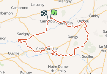
Trail Mountain bike of 38 km to be discovered at Normandy, Manche, Cametours. This trail is proposed by tracegps.

Description

Circuit au départ de Cametours et qui emprunte une série de GR. Ciruit sportif qui monte jusqu'à Monpinchon. A noter que la fin du circuit emprunte la route sur les 7 derniers Kms.

Elevation profile

Positioning

Country:
France
Region :
Normandy
Department/Province :
Manche
Municipality :
Cametours
Location:
Unknown
Start:(UTM)
625838 ; 5436815 (30U) N.

Trails nearby

Trail Mountain bike Cerisy-la-Salle - Cerisy La Salle - Photo
Mountain bike
stephbab1

Mountain bike

Medium
Cerisy-la-Salle, Normandy, Manche, France
9 km | 11.8 km-effort
59min
Yes
Trail Walking Marigny-Le-Lozon - Marigny - Photo
Walking
Roulland

Walking

Very easy
Marigny-Le-Lozon, Normandy, Manche, France
11.3 km | 13.4 km-effort
2h 18min
Yes
Trail Equestrian Le Lorey - le lorey - Photo
Equestrian
pleviautre

Equestrian

Very easy
Le Lorey, Normandy, Manche, France
9.6 km | 10.8 km-effort
1h 37min
Yes
Trail Other activity Montpinchon - 18mai2013 - Photo
Other activity
pleviautre

Other activity

Very easy
Montpinchon, Normandy, Manche, France
23 km | 28 km-effort
3h 19min
No
Trail Mountain bike Savigny - VTT entre Soulles et Sauvagère II - Photo
Mountain bike
tracegps

Mountain bike

Difficult
Savigny, Normandy, Manche, France
43 km | 53 km-effort
3h 0min
Yes
Trail Mountain bike Carantilly - Cametours par Montpinchon - Photo
Mountain bike
tracegps

Mountain bike

Difficult
Carantilly, Normandy, Manche, France
48 km | 57 km-effort
3h 30min
No
Trail Walking Marigny-Le-Lozon - Marigny le lozon - Photo
Walking
Yvon59

Walking

Medium
Marigny-Le-Lozon, Normandy, Manche, France
10.3 km | 11.7 km-effort
2h 35min
Yes
Trail Walking Le Mesnil-Amey - Le Mesnil Hamey - Photo
Walking
Bubux

Walking

Medium
Le Mesnil-Amey, Normandy, Manche, France
8.3 km | 9.9 km-effort
2h 41min
No
Trail Walking Marigny-Le-Lozon - MARIGNY 23K - Photo
Walking
UDGI54

Walking

Very difficult
Marigny-Le-Lozon, Normandy, Manche, France
23 km | 28 km-effort
6h 16min
Yes


Close
My subscriptions