![](/images/other/stat-length.png)
![Trail Equestrian Ruaudin - Circuit des Bondes - Ruaudin - Photo](https://media.geolcdn.com/t/1900/400/ext.pjpeg?maxdim=2&url=https%3A%2F%2Fservices.sitytrail.com%2FGeolivesWS%2FDownloadMedia.ashx%3FTrailID%3D106203%26Media%3D10492_4.jpg)
Circuit des Bondes - Ruaudin
tracegps
User
![Length](/images/other/stat-length.png)
Length
12.9 km
![Max alt](https://static1.geolcdn.com/siteimages/upload/files/1508320355ic_sort_altitude_max_24dp.png)
Max alt
76 m
![Uphill gradient](https://static1.geolcdn.com/siteimages/upload/files/1508320355ic_sort_den_pos_24dp.png)
Uphill gradient
88 m
![Km-Effort](/images/other/stat-length.png)
Km-Effort
14.1 km
![Min alt](https://static1.geolcdn.com/siteimages/upload/files/1508320355ic_sort_altitude_min_24dp.png)
Min alt
50 m
![Downhill gradient](https://static1.geolcdn.com/siteimages/upload/files/1508320355ic_sort_den_neg_24dp.png)
Downhill gradient
88 m
![Boucle](https://static1.geolcdn.com/siteimages/upload/files/16400158638029165_repeat_loop_refresh_sync_direction_icon.png)
Boucle
Yes
Creation date :
2014-12-10 00:00:00.0
Updated on :
2014-12-10 00:00:00.0
![Equestrian](https://static1.geolcdn.com/sitytour/trail-icons/300.png)
2h19
Difficulty : Medium
![Scan this QR Code to open this trail in the SityTrail application](https://capi.geolives.com/qq0zvz2zws4bq2lad0pu/sitytour/trails/106203/qr.png?size=200)
FREE GPS app for hiking
About
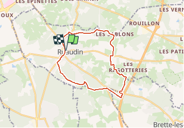
Trail Equestrian of 12.9 km to be discovered at Pays de la Loire, Sarthe, Ruaudin. This trail is proposed by tracegps.
Description
Circuit proposé par la commune de Ruaudin. Départ du parking de l'église de Ruaudin. Retrouvez le circuit sur le site de la commune de Ruaudin.
Positioning
Country:
France
Region :
Pays de la Loire
Department/Province :
Sarthe
Municipality :
Ruaudin
Location:
Unknown
Start:(Dec)
Start:(UTM)
295713 ; 5313682 (31T) N.
Comments
Trails nearby
![Trail Mountain bike Changé - Boucle Le Mans - Changé - Brettes - Parigné - Challes 53 km - Photo](https://media.geolcdn.com/t/375/260/ext.jpg?maxdim=2&url=https%3A%2F%2Fservices.sitytrail.com%2FGeolivesWS%2FDownloadMedia.ashx%3FTrailID%3D172382%26Media%3D13727_1.jpg)
![Mountain bike Mountain bike](https://static1.geolcdn.com/sitytour/trail-icons/202.png)
Boucle Le Mans - Changé - Brettes - Parigné - Challes 53 km
Mountain bike
Medium
(2)
Changé,
Pays de la Loire,
Sarthe,
France
![](/images/other/stat-length.png)
53 km | 60 km-effort
2h 30min
![](https://static1.geolcdn.com/siteimages/upload/files/16400158638029165_repeat_loop_refresh_sync_direction_icon.png)
No
![Trail Mountain bike Ruaudin - Circuit des Bondes - Ruaudin - Photo](https://media.geolcdn.com/t/375/260/ext.jpg?maxdim=2&url=https%3A%2F%2Fservices.sitytrail.com%2FGeolivesWS%2FDownloadMedia.ashx%3FTrailID%3D106202%26Media%3D10492_4.jpg)
![Mountain bike Mountain bike](https://static1.geolcdn.com/sitytour/trail-icons/202.png)
Circuit des Bondes - Ruaudin
Mountain bike
Medium
Ruaudin,
Pays de la Loire,
Sarthe,
France
![](/images/other/stat-length.png)
12.9 km | 14.1 km-effort
1h 45min
![](https://static1.geolcdn.com/siteimages/upload/files/16400158638029165_repeat_loop_refresh_sync_direction_icon.png)
Yes
![Trail Walking Ruaudin - Circuit des Bondes - Ruaudin - Photo](https://media.geolcdn.com/t/375/260/ext.jpg?maxdim=2&url=https%3A%2F%2Fservices.sitytrail.com%2FGeolivesWS%2FDownloadMedia.ashx%3FTrailID%3D106201%26Media%3D10492_4.jpg)
![Walking Walking](https://static1.geolcdn.com/sitytour/trail-icons/101.png)
Circuit des Bondes - Ruaudin
Walking
Difficult
(4)
Ruaudin,
Pays de la Loire,
Sarthe,
France
![](/images/other/stat-length.png)
12.9 km | 14.1 km-effort
3h 15min
![](https://static1.geolcdn.com/siteimages/upload/files/16400158638029165_repeat_loop_refresh_sync_direction_icon.png)
Yes
![Trail sport Changé - 2024-01-20_22h44m29_exp_13-01-24_traces - Photo](https://media.geolcdn.com/t/375/260/ext.jpg?maxdim=2&url=https%3A%2F%2Fsecurestorage.geolives.com%2Fsitytour%2Ftrail-bg%2Fdefault.jpg)
2024-01-20_22h44m29_exp_13-01-24_traces
sport
Very easy
(1)
Changé,
Pays de la Loire,
Sarthe,
France
![](/images/other/stat-length.png)
36 km | 42 km-effort
Unknown
![](https://static1.geolcdn.com/siteimages/upload/files/16400158638029165_repeat_loop_refresh_sync_direction_icon.png)
No
![Trail sport Changé - 2024-01-12_13h36m15_exp_10-01-24_traces - Photo](https://media.geolcdn.com/t/375/260/ext.jpg?maxdim=2&url=https%3A%2F%2Fsecurestorage.geolives.com%2Fsitytour%2Ftrail-bg%2Fdefault.jpg)
2024-01-12_13h36m15_exp_10-01-24_traces
sport
Very easy
Changé,
Pays de la Loire,
Sarthe,
France
![](/images/other/stat-length.png)
36 km | 42 km-effort
Unknown
![](https://static1.geolcdn.com/siteimages/upload/files/16400158638029165_repeat_loop_refresh_sync_direction_icon.png)
Yes
![Trail Hybrid bike Changé - reco le mans sept 2021 - Photo](https://media.geolcdn.com/t/375/260/e04116a1-4473-42b8-850e-ac7426d645c6.jpg&format=jpg&maxdim=2)
![Hybrid bike Hybrid bike](https://static1.geolcdn.com/sitytour/trail-icons/203.png)
reco le mans sept 2021
Hybrid bike
Easy
Changé,
Pays de la Loire,
Sarthe,
France
![](/images/other/stat-length.png)
15.4 km | 17 km-effort
1h 38min
![](https://static1.geolcdn.com/siteimages/upload/files/16400158638029165_repeat_loop_refresh_sync_direction_icon.png)
No
![Trail Walking Mulsanne - Marche a pied - Photo](https://media.geolcdn.com/t/375/260/5ef32b5e-c4b8-432e-ac82-e2f5840abe7a.jpg&format=jpg&maxdim=2)
![Walking Walking](https://static1.geolcdn.com/sitytour/trail-icons/101.png)
Marche a pied
Walking
Very easy
Mulsanne,
Pays de la Loire,
Sarthe,
France
![](/images/other/stat-length.png)
11.9 km | 13.4 km-effort
2h 46min
![](https://static1.geolcdn.com/siteimages/upload/files/16400158638029165_repeat_loop_refresh_sync_direction_icon.png)
Yes
![Trail Walking Changé - grand tour des bois de changé le Mans - Photo](https://media.geolcdn.com/t/375/260/ext.jpg?maxdim=2&url=https%3A%2F%2Fstatic1.geolcdn.com%2Fsiteimages%2Fupload%2Ffiles%2F1553511878bg_sport_marche.png)
![Walking Walking](https://static1.geolcdn.com/sitytour/trail-icons/101.png)
grand tour des bois de changé le Mans
Walking
Very easy
Changé,
Pays de la Loire,
Sarthe,
France
![](/images/other/stat-length.png)
11.9 km | 13.6 km-effort
2h 45min
![](https://static1.geolcdn.com/siteimages/upload/files/16400158638029165_repeat_loop_refresh_sync_direction_icon.png)
Yes
![Trail Walking Changé - des Chalottières aux Perdrielles - Photo](https://media.geolcdn.com/t/375/260/ext.jpg?maxdim=2&url=https%3A%2F%2Fstatic1.geolcdn.com%2Fsiteimages%2Fupload%2Ffiles%2F1553511878bg_sport_marche.png)
![Walking Walking](https://static1.geolcdn.com/sitytour/trail-icons/101.png)
des Chalottières aux Perdrielles
Walking
Very easy
Changé,
Pays de la Loire,
Sarthe,
France
![](/images/other/stat-length.png)
4.2 km | 4.8 km-effort
1h 4min
![](https://static1.geolcdn.com/siteimages/upload/files/16400158638029165_repeat_loop_refresh_sync_direction_icon.png)
No