Trail Walking Lagardelle-sur-Lèze - boucle lagardelle beaumont - Photo

boucle lagardelle beaumont

 VACHER31
VACHER31

User

© OpenStreetMap contributors
Length
Length
9.1 km
Max alt
Max alt
225 m
Uphill gradient
Uphill gradient
108 m
Km-Effort
Km-Effort  
10.5 km
Min alt
Min alt
181 m
Downhill gradient
Downhill gradient
108 m
Boucle
Boucle
Yes
Creation date :
2019-01-15 17:56:19.977
Updated on :
2019-07-28 06:59:59.743

(0 Reviews)

Walking
Walking
1h52
Difficulty : Easy

Scan this QR Code to open this trail in the SityTrail application

FREE GPS app for hiking

Logo SityTrail SityTrail

IGN / Geographical institutes

Download SityTrail from the App Store Download SityTrail from Google Play

Logo SityTrail SityTrail World

The world is yours!

Download SityTrail from the App Store Download SityTrail from Google Play Download SityTrail on Huawei AppGallery

About

Trail Walking of 9.1 km to be discovered at Occitania, Haute-Garonne, Lagardelle-sur-Lèze. This trail is proposed by VACHER31.

Elevation profile

Positioning

Country:
France
Region :
Occitania
Department/Province :
Haute-Garonne
Municipality :
Lagardelle-sur-Lèze
Location:
Unknown
Start:(UTM)
370100 ; 4806663 (31T) N.

Trails nearby

Trail Walking Beaumont-sur-Lèze - Beaumont Hournet - Photo
Walking
pidjam

Walking

Easy
(1)
Beaumont-sur-Lèze, Occitania, Haute-Garonne, France
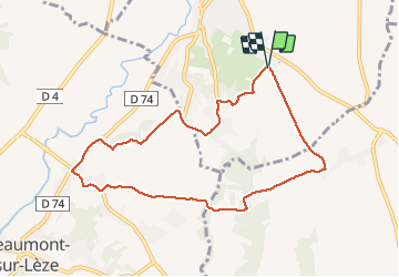
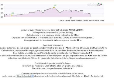
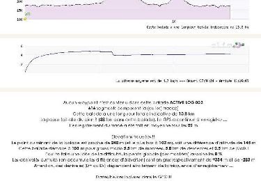
10.7 km | 13.7 km-effort
2h 35min
Yes
Trail Walking Eaunes - EAUNES-CHAPELLE ST AMANS en boucle - Photo
Walking
chrisgps

Walking

Easy
Eaunes, Occitania, Haute-Garonne, France
10.9 km | 14.3 km-effort
2h 49min
Yes
Trail Walking Eaunes - EAUNES-CHAPELLE ST AMANS en boucle - Photo
Walking
chrisgps

Walking

Medium
Eaunes, Occitania, Haute-Garonne, France
11 km | 14.5 km-effort
2h 34min
Yes
Trail Mountain bike Lagardelle-sur-Lèze - anniversaire Lilian  - Photo
Mountain bike
Zoïa Pascal

Mountain bike

Very easy
Lagardelle-sur-Lèze, Occitania, Haute-Garonne, France
10.8 km | 11.7 km-effort
41min
Yes
Trail Walking Grépiac - Randonnée autour de Grépiac  - Photo
Walking
tracegps

Walking

Medium
(1)
Grépiac, Occitania, Haute-Garonne, France
13 km | 16.1 km-effort
4h 0min
Yes
Trail Walking Venerque - Boucle à Venerque - Photo
Walking
tracegps

Walking

Medium
Venerque, Occitania, Haute-Garonne, France
13.8 km | 16.3 km-effort
3h 30min
Yes
Trail Canoe - kayak Vernet - Ariège 2023 - Photo
Canoe - kayak
pates_au_chaud

Canoe - kayak

Very easy
Vernet, Occitania, Haute-Garonne, France
12.6 km | 14.1 km-effort
4h 44min
No
Trail Walking Venerque - vener crepiac - Photo
Walking
Bernard24

Walking

Very easy
(1)
Venerque, Occitania, Haute-Garonne, France
8.3 km | 9.6 km-effort
2h 43min
Yes
Trail Walking Beaumont-sur-Lèze - silo eaunes - Photo
Walking
Bernard24

Walking

Medium
Beaumont-sur-Lèze, Occitania, Haute-Garonne, France
8.3 km | 11.2 km-effort
2h 51min
Yes


Close
My subscriptions