Trail Walking Heuvelland - Loker - Le Mont Rouge - Photo

Loker - Le Mont Rouge

 tracegps
tracegps

User

© OpenStreetMap contributors
Length
Length
8.7 km
Max alt
Max alt
142 m
Uphill gradient
Uphill gradient
154 m
Km-Effort
Km-Effort  
10.8 km
Min alt
Min alt
61 m
Downhill gradient
Downhill gradient
152 m
Boucle
Boucle
Yes
Creation date :
2014-12-10 00:00:00.0
Updated on :
2014-12-10 00:00:00.0

(3 Reviews)

Walking
Walking
2h19
Difficulty : Medium

Scan this QR Code to open this trail in the SityTrail application

FREE GPS app for hiking

Logo SityTrail SityTrail

IGN / Geographical institutes

Download SityTrail from the App Store Download SityTrail from Google Play

Logo SityTrail SityTrail World

The world is yours!

Download SityTrail from the App Store Download SityTrail from Google Play Download SityTrail on Huawei AppGallery

About

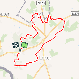
Trail Walking of 8.7 km to be discovered at Flanders, West Flanders, Heuvelland. This trail is proposed by tracegps.

Description

Procurez vous si possible à l'O.T. de Kemmel la carte du réseau pédestre des 'Monts de Flandre'. La balade proposée suit les balises : 36 - 37 - 40 - 41 - 43 - 44 - 45 - 49 - 50 - 52 - 70 - 71 - 13 - 12 - 28 - 29 - 27 - 26 - 25 - 33 - 35 - 36. Le départ est fixé au Lijstermolen. Ce moulin en bois fut construit en 1805 et mis en service à Beernem. En 1960 il fut transféré ici et remis en service l'année suivante. Après de superbes vues sur la France toute proche (Bailleul) vous arrivez au Scherpenberg (Mont Aïgu) culminant à 125 mètres. Cet endroit fut utilisé par les troupes britanniques pour pouvoir se localiser. Vous traverserez ensuite les réserves naturelles du Scherpenberg, du Branderbos et du 'Sulferberg' popur revenir vers le bois du 'Kotje Piepers' et le Mont Rouge. En mai, ce bois est largement couvert jacinthes sauvages.

Elevation profile

Photos

Positioning

Country:
Belgium
Region :
Flanders
Department/Province :
West Flanders
Municipality :
Heuvelland
Location:
Westouter
Start:(UTM)
482977 ; 5625914 (31U) N.

Comments

Please log in to post a review or rate the element


Très belle balade.


Super


Trails nearby

Trail Walking Heuvelland - Monts Rouge et Noir - Photo
Walking
Greg813

Walking

Difficult
(1)
Heuvelland, Flanders, West Flanders, Belgium
24 km | 30 km-effort
5h 27min
Yes
Trail On foot Heuvelland - Geuzen wandelroute - Photo
On foot
GUIDE+

On foot

Easy
Heuvelland, Flanders, West Flanders, Belgium
9.7 km | 11.4 km-effort
2h 35min
Yes
Trail On foot Heuvelland - Kemmelberg wandelroute - Photo
On foot
GUIDE+

On foot

Easy
Heuvelland, Flanders, West Flanders, Belgium
8.9 km | 11.4 km-effort
2h 36min
Yes
Trail On foot Heuvelland - Tweebergen wandelroute - Photo
On foot
GUIDE+

On foot

Easy
Heuvelland, Flanders, West Flanders, Belgium
7.3 km | 9 km-effort
2h 2min
Yes
Trail Walking Heuvelland - Westouter langs tweetermen - Photo
Walking
Wesley Samyn

Walking

Difficult
(1)
Heuvelland, Flanders, West Flanders, Belgium
7.5 km | 9.1 km-effort
2h 4min
Yes
Trail Motor Bailleul - 104 - Photo
Motor
abalcerek

Motor

Very easy
(3)
Bailleul, Hauts-de-France, Nord, France
127 km | 140 km-effort
3h 49min
No
Trail Walking Saint-Jans-Cappel - sentier des jacynthes - Photo
Walking
Bernard.voyageur

Walking

Medium
(1)
Saint-Jans-Cappel, Hauts-de-France, Nord, France
7.3 km | 9.2 km-effort
2h 1min
Yes
Trail Walking Bailleul - camping de la Ferme des Saules à côté de Bailleul, arrivée Deulemont - Photo
Walking
jeff2

Walking

Medium
Bailleul, Hauts-de-France, Nord, France
32 km | 34 km-effort
9h 10min
No
Trail Walking Heuvelland - Dranouter 12,3 km - Photo
Walking
GUIDE
rvapeldo

Walking

Easy
Heuvelland, Flanders, West Flanders, Belgium
12.4 km | 14.5 km-effort
3h 32min
Yes


Close
My subscriptions