![](/images/other/stat-length.png)
![Trail Mountain bike Lascelle - Espace VTT FFC - Grand Site du Puy Mary - Vallée de la Jordanne - Circuit N°6 Pempadouyre - Photo](https://media.geolcdn.com/t/1900/400/ext.pjpeg?maxdim=2&url=https%3A%2F%2Fstatic1.geolcdn.com%2Fsiteimages%2Fupload%2Ffiles%2F1524743154velo.jpg)
Espace VTT FFC - Grand Site du Puy Mary - Vallée de la Jordanne - Circuit N°6 Pempadouyre
tracegps
User
![Length](/images/other/stat-length.png)
![Max alt](https://static1.geolcdn.com/siteimages/upload/files/1508320355ic_sort_altitude_max_24dp.png)
![Uphill gradient](https://static1.geolcdn.com/siteimages/upload/files/1508320355ic_sort_den_pos_24dp.png)
![Km-Effort](/images/other/stat-length.png)
![Min alt](https://static1.geolcdn.com/siteimages/upload/files/1508320355ic_sort_altitude_min_24dp.png)
![Downhill gradient](https://static1.geolcdn.com/siteimages/upload/files/1508320355ic_sort_den_neg_24dp.png)
![Boucle](https://static1.geolcdn.com/siteimages/upload/files/16400158638029165_repeat_loop_refresh_sync_direction_icon.png)
![Mountain bike](https://static1.geolcdn.com/sitytour/trail-icons/202.png)
3h00
Difficulty : Difficult
![Scan this QR Code to open this trail in the SityTrail application](https://capi.geolives.com/qq0zvz2zws4bq2lad0pu/sitytour/trails/106130/qr.png?size=200)
FREE GPS app for hiking
About
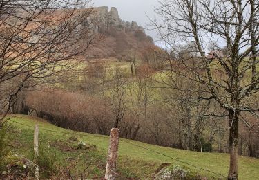
Trail Mountain bike of 18 km to be discovered at Auvergne-Rhône-Alpes, Cantal, Lascelle. This trail is proposed by tracegps.
Description
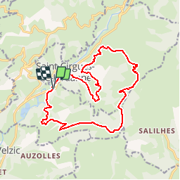
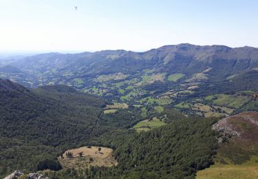
Espace VTT FFC – Grand Site du Puy Mary – Vallée de la Jordanne - Circuit N°6 Pempadouyre Circuit officiel labellisé par la Fédération Française de Cyclisme. Un coup de coeur… (Regardez la forme du circuit...).L’itinéraire résume à lui seul la variété des paysages du Volcan cantalien et la valeur « vététistique » de ses sentiers. Une montée alpine (montade en patois) vous conduit au Pempadouyre (1 289m). N’attendez pas alors la St-Géraud* pour la « dévalade » sur le sentier technique de la Glèbe en direction du Chaumeil et de St-Cirguesde-Jordanne… Un bon circuit pour débuter votre visite du site VTT-FFC N°58 ! * St Géraud : 15 octobre, descente des troupeaux.
Positioning
Comments
Trails nearby
![Trail Hybrid bike Mandailles-Saint-Julien - Tournemire - Photo](https://media.geolcdn.com/t/375/260/e14f03b2-11fc-4b1e-a416-809203cb4d66.jpg&format=jpg&maxdim=2)
![Hybrid bike Hybrid bike](https://static1.geolcdn.com/sitytour/trail-icons/203.png)
Hybrid bike
![](/images/other/stat-length.png)
![](https://static1.geolcdn.com/siteimages/upload/files/16400158638029165_repeat_loop_refresh_sync_direction_icon.png)
![Trail On foot Saint-Cirgues-de-Jordanne - Le Chaumeil - Photo](https://media.geolcdn.com/t/375/260/53ff843e-c80c-4472-b970-b0e67f3b101f.jpeg&format=jpg&maxdim=2)
![On foot On foot](https://static1.geolcdn.com/sitytour/trail-icons/100.png)
On foot
![](/images/other/stat-length.png)
![](https://static1.geolcdn.com/siteimages/upload/files/16400158638029165_repeat_loop_refresh_sync_direction_icon.png)
![Trail Walking Lascelle - Roman de Jordanne - Photo](https://media.geolcdn.com/t/375/260/ext.jpg?maxdim=2&url=https%3A%2F%2Fstatic1.geolcdn.com%2Fsiteimages%2Fupload%2Ffiles%2F1553511878bg_sport_marche.png)
![Walking Walking](https://static1.geolcdn.com/sitytour/trail-icons/101.png)
Walking
![](/images/other/stat-length.png)
![](https://static1.geolcdn.com/siteimages/upload/files/16400158638029165_repeat_loop_refresh_sync_direction_icon.png)
![Trail Trail Vic-sur-Cère - Cascade, la Garde, grotte des anglais - Photo](https://media.geolcdn.com/t/375/260/2f654d5e-2308-4101-8214-c057fbfbda64.jpg&format=jpg&maxdim=2)
![Trail Trail](https://static1.geolcdn.com/sitytour/trail-icons/104.png)
Trail
![](/images/other/stat-length.png)
![](https://static1.geolcdn.com/siteimages/upload/files/16400158638029165_repeat_loop_refresh_sync_direction_icon.png)
![Trail Walking Lascelle - Arbre de quenouille, rocher saint curial, col de berganti - Photo](https://media.geolcdn.com/t/375/260/7c9d82cf-6b3d-4485-8853-0a39a0f6136c.jpg&format=jpg&maxdim=2)
![Walking Walking](https://static1.geolcdn.com/sitytour/trail-icons/101.png)
Walking
![](/images/other/stat-length.png)
![](https://static1.geolcdn.com/siteimages/upload/files/16400158638029165_repeat_loop_refresh_sync_direction_icon.png)
![Trail Walking Laroquevieille - col du bruel - Photo](https://media.geolcdn.com/t/375/260/d47dbd1d-15d2-46f9-87a2-ab30b3adeb21.jpg&format=jpg&maxdim=2)
![Walking Walking](https://static1.geolcdn.com/sitytour/trail-icons/101.png)
Walking
![](/images/other/stat-length.png)
![](https://static1.geolcdn.com/siteimages/upload/files/16400158638029165_repeat_loop_refresh_sync_direction_icon.png)
![Trail Walking Mandailles-Saint-Julien - Roches folles - Photo](https://media.geolcdn.com/t/375/260/8984fadf-4f9b-4d7e-9bc1-4440944bdfaa.jpg&format=jpg&maxdim=2)
![Walking Walking](https://static1.geolcdn.com/sitytour/trail-icons/101.png)
Walking
![](/images/other/stat-length.png)
![](https://static1.geolcdn.com/siteimages/upload/files/16400158638029165_repeat_loop_refresh_sync_direction_icon.png)
![Trail Walking Saint-Cirgues-de-Jordanne - La Flandonnière - Photo](https://media.geolcdn.com/t/375/260/ext.jpg?maxdim=2&url=https%3A%2F%2Fstatic1.geolcdn.com%2Fsiteimages%2Fupload%2Ffiles%2F1553511878bg_sport_marche.png)
![Walking Walking](https://static1.geolcdn.com/sitytour/trail-icons/101.png)
Walking
![](/images/other/stat-length.png)
![](https://static1.geolcdn.com/siteimages/upload/files/16400158638029165_repeat_loop_refresh_sync_direction_icon.png)
![Trail Walking Mandailles-Saint-Julien - Puy Griou - Photo](https://media.geolcdn.com/t/375/260/ext.jpg?maxdim=2&url=https%3A%2F%2Fservices.sitytrail.com%2FGeolivesWS%2FDownloadMedia.ashx%3FTrailID%3D809793%26Media%3Dfix__20170814154553.jpg)
![Walking Walking](https://static1.geolcdn.com/sitytour/trail-icons/101.png)
Walking
![](/images/other/stat-length.png)
![](https://static1.geolcdn.com/siteimages/upload/files/16400158638029165_repeat_loop_refresh_sync_direction_icon.png)