![](/images/other/stat-length.png)
![Trail Mountain bike Carry-le-Rouet - Randonnée VTT - L'Estaque - Calanque des Eaux Salées - Photo](https://media.geolcdn.com/t/1900/400/ext.pjpeg?maxdim=2&url=https%3A%2F%2Fservices.sitytrail.com%2FGeolivesWS%2FDownloadMedia.ashx%3FTrailID%3D106079%26Media%3D10261_1.jpg)
Randonnée VTT - L'Estaque - Calanque des Eaux Salées
tracegps
User
![Length](/images/other/stat-length.png)
![Max alt](https://static1.geolcdn.com/siteimages/upload/files/1508320355ic_sort_altitude_max_24dp.png)
![Uphill gradient](https://static1.geolcdn.com/siteimages/upload/files/1508320355ic_sort_den_pos_24dp.png)
![Km-Effort](/images/other/stat-length.png)
![Min alt](https://static1.geolcdn.com/siteimages/upload/files/1508320355ic_sort_altitude_min_24dp.png)
![Downhill gradient](https://static1.geolcdn.com/siteimages/upload/files/1508320355ic_sort_den_neg_24dp.png)
![Boucle](https://static1.geolcdn.com/siteimages/upload/files/16400158638029165_repeat_loop_refresh_sync_direction_icon.png)
![Mountain bike](https://static1.geolcdn.com/sitytour/trail-icons/202.png)
3h00
Difficulty : Medium
![Scan this QR Code to open this trail in the SityTrail application](https://capi.geolives.com/qq0zvz2zws4bq2lad0pu/sitytour/trails/106079/qr.png?size=200)
FREE GPS app for hiking
About
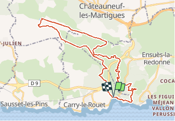
Trail Mountain bike of 22 km to be discovered at Provence-Alpes-Côte d'Azur, Bouches-du-Rhône, Carry-le-Rouet. This trail is proposed by tracegps.
Description
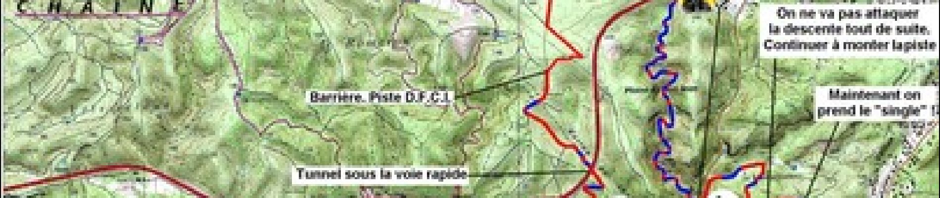
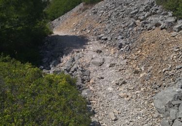
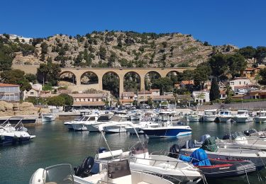
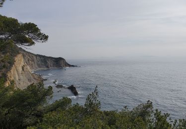
Très joli parcours hivernal. Pas trop long et pas trop de dénivelé. Le départ est un peu rude. On est au niveau de la mer et il faut sortir de là : ça monte tout de suite ! La partie vers le bassin de Valtrède est bien roulante. Le long mono trace du vallon du Bon Jean est très agréable et sans difficulté. La traversée du petit tunnel en tôle ondulée est marrante. La descente sur la calanque des Eaux Salées est très jolie et vaut vraiment le coup, même si on doit porter le vélo 5 minutes pour monter les escaliers du viaduc. Attention, du 01 juin au 30 septembre l'accès aux massifs forestiers est réglementé. Le niveau de danger du jour est défini la veille pour le lendemain à partir de 18h00 et consultable ICI ou en appelant le serveur vocal dédié au 08 11 20 13 13. Bonne randonnée. Vos commentaires et remarques diverses sont les bienvenus. Pour zoomer sur l'image, cliquer sur ce lien puis vous activerez le zoom en cliquant sur la loupe avec le signe plus.
Positioning
Comments
Trails nearby
![Trail Walking Carry-le-Rouet - EnsuesLaRedonneDépartCarryObservatoire - Photo](https://media.geolcdn.com/t/375/260/ext.jpg?maxdim=2&url=https%3A%2F%2Fstatic1.geolcdn.com%2Fsiteimages%2Fupload%2Ffiles%2F1553511878bg_sport_marche.png)
![Walking Walking](https://static1.geolcdn.com/sitytour/trail-icons/101.png)
Walking
![](/images/other/stat-length.png)
![](https://static1.geolcdn.com/siteimages/upload/files/16400158638029165_repeat_loop_refresh_sync_direction_icon.png)
![Trail On foot Carry-le-Rouet - Le Vallon de Jaume par les Grottes - Photo](https://media.geolcdn.com/t/375/260/0b2898cd-0732-4408-b545-ff0a18859a39.jpeg&format=jpg&maxdim=2)
![On foot On foot](https://static1.geolcdn.com/sitytour/trail-icons/100.png)
On foot
![](/images/other/stat-length.png)
![](https://static1.geolcdn.com/siteimages/upload/files/16400158638029165_repeat_loop_refresh_sync_direction_icon.png)
![Trail On foot Carry-le-Rouet - Le Tour du Romaron - Photo](https://media.geolcdn.com/t/375/260/1a32f56d-69e4-4cf2-b186-82726e0bad5b.jpeg&format=jpg&maxdim=2)
![On foot On foot](https://static1.geolcdn.com/sitytour/trail-icons/100.png)
On foot
![](/images/other/stat-length.png)
![](https://static1.geolcdn.com/siteimages/upload/files/16400158638029165_repeat_loop_refresh_sync_direction_icon.png)
![Trail On foot Carry-le-Rouet - Entre calanques et collines - Photo](https://media.geolcdn.com/t/375/260/1a32f56d-69e4-4cf2-b186-82726e0bad5b.jpeg&format=jpg&maxdim=2)
![On foot On foot](https://static1.geolcdn.com/sitytour/trail-icons/100.png)
On foot
![](/images/other/stat-length.png)
![](https://static1.geolcdn.com/siteimages/upload/files/16400158638029165_repeat_loop_refresh_sync_direction_icon.png)
![Trail On foot Ensuès-la-Redonne - Grand Sentier de la Côte Bleue - Photo](https://media.geolcdn.com/t/375/260/e6d2f765-bb75-419b-b14b-35c0d85ab7e2.jpeg&format=jpg&maxdim=2)
![On foot On foot](https://static1.geolcdn.com/sitytour/trail-icons/100.png)
On foot
![](/images/other/stat-length.png)
![](https://static1.geolcdn.com/siteimages/upload/files/16400158638029165_repeat_loop_refresh_sync_direction_icon.png)
![Trail Walking Ensuès-la-Redonne - 13 Méjean ebeverine redonne 02.06.24 - Photo](https://media.geolcdn.com/t/375/260/30275aea-f634-4b8c-9c44-057ae4001fc3.jpg&format=jpg&maxdim=2)
![Walking Walking](https://static1.geolcdn.com/sitytour/trail-icons/101.png)
Walking
![](/images/other/stat-length.png)
![](https://static1.geolcdn.com/siteimages/upload/files/16400158638029165_repeat_loop_refresh_sync_direction_icon.png)
![Trail Walking Ensuès-la-Redonne - La Redonne - Calanques des Anthénors et de Figuières - Photo](https://media.geolcdn.com/t/375/260/8a6fb41f-97ad-44cb-8c06-9a4b2c8de457.jpg&format=jpg&maxdim=2)
![Walking Walking](https://static1.geolcdn.com/sitytour/trail-icons/101.png)
Walking
![](/images/other/stat-length.png)
![](https://static1.geolcdn.com/siteimages/upload/files/16400158638029165_repeat_loop_refresh_sync_direction_icon.png)
![Trail Walking Carry-le-Rouet - L'Estaque - Le Sentier du Lézard - Photo](https://media.geolcdn.com/t/375/260/5c48ce05-c987-4dd3-ba21-a19c1b71e8fe.jpg&format=jpg&maxdim=2)
![Walking Walking](https://static1.geolcdn.com/sitytour/trail-icons/101.png)
Walking
![](/images/other/stat-length.png)
![](https://static1.geolcdn.com/siteimages/upload/files/16400158638029165_repeat_loop_refresh_sync_direction_icon.png)
![Trail Walking Ensuès-la-Redonne - laRedonne le grand Méjan - Photo](https://media.geolcdn.com/t/375/260/7a6cd11d-21b3-489a-b0eb-328fab0c5232.jpg&format=jpg&maxdim=2)
![Walking Walking](https://static1.geolcdn.com/sitytour/trail-icons/101.png)
Walking
![](/images/other/stat-length.png)
![](https://static1.geolcdn.com/siteimages/upload/files/16400158638029165_repeat_loop_refresh_sync_direction_icon.png)