![](/images/other/stat-length.png)
![Trail Mountain bike Saint-Jean-d'Hérans - Les vignes de Masserange - Saint Jean d'Hérans - Photo](https://media.geolcdn.com/t/1900/400/ext.pjpeg?maxdim=2&url=https%3A%2F%2Fstatic1.geolcdn.com%2Fsiteimages%2Fupload%2Ffiles%2F1524743154velo.jpg)
Les vignes de Masserange - Saint Jean d'Hérans
tracegps
User
![Length](/images/other/stat-length.png)
Length
5.2 km
![Max alt](https://static1.geolcdn.com/siteimages/upload/files/1508320355ic_sort_altitude_max_24dp.png)
Max alt
874 m
![Uphill gradient](https://static1.geolcdn.com/siteimages/upload/files/1508320355ic_sort_den_pos_24dp.png)
Uphill gradient
129 m
![Km-Effort](/images/other/stat-length.png)
Km-Effort
6.9 km
![Min alt](https://static1.geolcdn.com/siteimages/upload/files/1508320355ic_sort_altitude_min_24dp.png)
Min alt
778 m
![Downhill gradient](https://static1.geolcdn.com/siteimages/upload/files/1508320355ic_sort_den_neg_24dp.png)
Downhill gradient
128 m
![Boucle](https://static1.geolcdn.com/siteimages/upload/files/16400158638029165_repeat_loop_refresh_sync_direction_icon.png)
Boucle
Yes
Creation date :
2014-12-10 00:00:00.0
Updated on :
2014-12-10 00:00:00.0
![Mountain bike](https://static1.geolcdn.com/sitytour/trail-icons/202.png)
19m
Difficulty : Easy
![Scan this QR Code to open this trail in the SityTrail application](https://capi.geolives.com/qq0zvz2zws4bq2lad0pu/sitytour/trails/106049/qr.png?size=200)
FREE GPS app for hiking
About
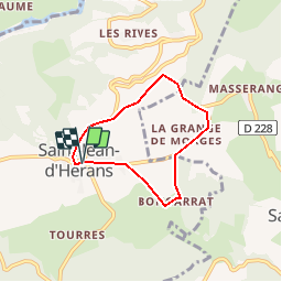
Trail Mountain bike of 5.2 km to be discovered at Auvergne-Rhône-Alpes, Isère, Saint-Jean-d'Hérans. This trail is proposed by tracegps.
Description
Circuit n°11 (vert) de la base VTT FFCT du Trièves. Empruntant des chemins herbeux ou gravillonnés, des routes peu fréquentées, ce parcours sur le plateau de St Jean d'Hérans est idéal pour faire ses premiers pas en VTT, ou pour une sortie facile en famille
Positioning
Country:
France
Region :
Auvergne-Rhône-Alpes
Department/Province :
Isère
Municipality :
Saint-Jean-d'Hérans
Location:
Unknown
Start:(Dec)
Start:(UTM)
718231 ; 4970339 (31T) N.
Comments
Trails nearby
![Trail Walking Châtel-en-Trièves - Arête de Rattier depuis le col de la brêche - Photo](https://media.geolcdn.com/t/375/260/645aac14-c825-4b01-9c22-da781fdfea33.jpg&format=jpg&maxdim=2)
![Walking Walking](https://static1.geolcdn.com/sitytour/trail-icons/101.png)
Arête de Rattier depuis le col de la brêche
Walking
Difficult
(1)
Châtel-en-Trièves,
Auvergne-Rhône-Alpes,
Isère,
France
![](/images/other/stat-length.png)
10.3 km | 24 km-effort
8h 12min
![](https://static1.geolcdn.com/siteimages/upload/files/16400158638029165_repeat_loop_refresh_sync_direction_icon.png)
Yes
![Trail Walking Mens - Bonnet Calvin reco - Photo](https://media.geolcdn.com/t/375/260/71237d58-2b29-4521-9351-2dded8929675.jpg&format=jpg&maxdim=2)
![Walking Walking](https://static1.geolcdn.com/sitytour/trail-icons/101.png)
Bonnet Calvin reco
Walking
Difficult
(1)
Mens,
Auvergne-Rhône-Alpes,
Isère,
France
![](/images/other/stat-length.png)
10.7 km | 21 km-effort
4h 25min
![](https://static1.geolcdn.com/siteimages/upload/files/16400158638029165_repeat_loop_refresh_sync_direction_icon.png)
No
![Trail Walking Mayres-Savel - Passerelles Hymalayene Mayres + 250 - Photo](https://media.geolcdn.com/t/375/260/e79ec6b2-c62a-43e0-95ca-91baa034bf5d.jpg&format=jpg&maxdim=2)
![Walking Walking](https://static1.geolcdn.com/sitytour/trail-icons/101.png)
Passerelles Hymalayene Mayres + 250
Walking
Medium
Mayres-Savel,
Auvergne-Rhône-Alpes,
Isère,
France
![](/images/other/stat-length.png)
4.9 km | 8.2 km-effort
1h 59min
![](https://static1.geolcdn.com/siteimages/upload/files/16400158638029165_repeat_loop_refresh_sync_direction_icon.png)
Yes
![Trail Walking Mens - bonnet de Calvin - Photo](https://media.geolcdn.com/t/375/260/809ecc75-03b4-4bae-9bda-776611be3043.jpg&format=jpg&maxdim=2)
![Walking Walking](https://static1.geolcdn.com/sitytour/trail-icons/101.png)
bonnet de Calvin
Walking
Medium
Mens,
Auvergne-Rhône-Alpes,
Isère,
France
![](/images/other/stat-length.png)
8.3 km | 16.9 km-effort
6h 10min
![](https://static1.geolcdn.com/siteimages/upload/files/16400158638029165_repeat_loop_refresh_sync_direction_icon.png)
Yes
![Trail Trail Prunières - Trail du 3ème Poste - Photo](https://media.geolcdn.com/t/375/260/b349c434-6c73-4e6c-8ff8-79e71a74ca19.jpg&format=jpg&maxdim=2)
![Trail Trail](https://static1.geolcdn.com/sitytour/trail-icons/104.png)
Trail du 3ème Poste
Trail
Medium
Prunières,
Auvergne-Rhône-Alpes,
Isère,
France
![](/images/other/stat-length.png)
17.7 km | 28 km-effort
2h 33min
![](https://static1.geolcdn.com/siteimages/upload/files/16400158638029165_repeat_loop_refresh_sync_direction_icon.png)
No
![Trail Walking Mens - bonnet de Calvin - Photo](https://media.geolcdn.com/t/375/260/e0867dac-c8ad-4bc3-be49-12c40a0ad975.jpg&format=jpg&maxdim=2)
![Walking Walking](https://static1.geolcdn.com/sitytour/trail-icons/101.png)
bonnet de Calvin
Walking
Easy
Mens,
Auvergne-Rhône-Alpes,
Isère,
France
![](/images/other/stat-length.png)
9.5 km | 18.9 km-effort
4h 15min
![](https://static1.geolcdn.com/siteimages/upload/files/16400158638029165_repeat_loop_refresh_sync_direction_icon.png)
Yes
![Trail Walking Mens - LE CHATEL depuis MENS-25-09-2016 - Photo](https://media.geolcdn.com/t/375/260/ext.jpg?maxdim=2&url=https%3A%2F%2Fservices.sitytrail.com%2FGeolivesWS%2FDownloadMedia.ashx%3FTrailID%3D636626%26Media%3D20160925155801.jpg)
![Walking Walking](https://static1.geolcdn.com/sitytour/trail-icons/101.png)
LE CHATEL depuis MENS-25-09-2016
Walking
Easy
Mens,
Auvergne-Rhône-Alpes,
Isère,
France
![](/images/other/stat-length.png)
11.9 km | 22 km-effort
4h 20min
![](https://static1.geolcdn.com/siteimages/upload/files/16400158638029165_repeat_loop_refresh_sync_direction_icon.png)
No
![Trail Walking Mens - Le Bonnet de Calvin - Photo](https://media.geolcdn.com/t/375/260/ext.jpg?maxdim=2&url=https%3A%2F%2Fstatic1.geolcdn.com%2Fsiteimages%2Fupload%2Ffiles%2F1553511878bg_sport_marche.png)
![Walking Walking](https://static1.geolcdn.com/sitytour/trail-icons/101.png)
Le Bonnet de Calvin
Walking
Medium
(2)
Mens,
Auvergne-Rhône-Alpes,
Isère,
France
![](/images/other/stat-length.png)
9.5 km | 18.7 km-effort
4h 58min
![](https://static1.geolcdn.com/siteimages/upload/files/16400158638029165_repeat_loop_refresh_sync_direction_icon.png)
Yes
![Trail Walking Saint-Jean-d'Hérans - Sur les Pas des Huguenots - Saint-Jean-D'Hérans - La Mure - Photo](https://media.geolcdn.com/t/375/260/ext.jpg?maxdim=2&url=https%3A%2F%2Fservices.sitytrail.com%2FGeolivesWS%2FDownloadMedia.ashx%3FTrailID%3D107593%26Media%3D12553_5.jpg)
![Walking Walking](https://static1.geolcdn.com/sitytour/trail-icons/101.png)
Sur les Pas des Huguenots - Saint-Jean-D'Hérans - La Mure
Walking
Difficult
Saint-Jean-d'Hérans,
Auvergne-Rhône-Alpes,
Isère,
France
![](/images/other/stat-length.png)
10.4 km | 15.5 km-effort
3h 0min
![](https://static1.geolcdn.com/siteimages/upload/files/16400158638029165_repeat_loop_refresh_sync_direction_icon.png)
No