![](/images/other/stat-length.png)
![Trail Running Cornillon-en-Trièves - Le Serre des 9 églises - Le Grand Oriol - Photo](https://media.geolcdn.com/t/1900/400/ext.pjpeg?maxdim=2&url=https%3A%2F%2Fstatic1.geolcdn.com%2Fsiteimages%2Fupload%2Ffiles%2F1524743154running.jpg)
Le Serre des 9 églises - Le Grand Oriol
tracegps
User
![Length](/images/other/stat-length.png)
Length
6.6 km
![Max alt](https://static1.geolcdn.com/siteimages/upload/files/1508320355ic_sort_altitude_max_24dp.png)
Max alt
892 m
![Uphill gradient](https://static1.geolcdn.com/siteimages/upload/files/1508320355ic_sort_den_pos_24dp.png)
Uphill gradient
217 m
![Km-Effort](/images/other/stat-length.png)
Km-Effort
9.5 km
![Min alt](https://static1.geolcdn.com/siteimages/upload/files/1508320355ic_sort_altitude_min_24dp.png)
Min alt
718 m
![Downhill gradient](https://static1.geolcdn.com/siteimages/upload/files/1508320355ic_sort_den_neg_24dp.png)
Downhill gradient
217 m
![Boucle](https://static1.geolcdn.com/siteimages/upload/files/16400158638029165_repeat_loop_refresh_sync_direction_icon.png)
Boucle
Yes
Creation date :
2014-12-10 00:00:00.0
Updated on :
2014-12-10 00:00:00.0
![Running](https://static1.geolcdn.com/sitytour/trail-icons/103.png)
40m
Difficulty : Medium
![Scan this QR Code to open this trail in the SityTrail application](https://capi.geolives.com/qq0zvz2zws4bq2lad0pu/sitytour/trails/106046/qr.png?size=200)
FREE GPS app for hiking
About
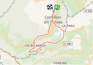
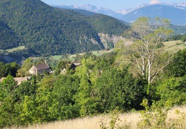
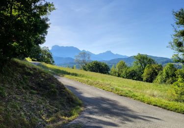
Trail Running of 6.6 km to be discovered at Auvergne-Rhône-Alpes, Isère, Cornillon-en-Trièves. This trail is proposed by tracegps.
Description
Circuit n°9 (bleu) de la base VTT FFCT du Trièves. Circuit agréable et roulant, idéal pour une pratique familiale, qui vous permet d'évoluer dans un décor agréable : panorama sur la chaîne de l'Obiou, champs cultivés, sous-bois.
Positioning
Country:
France
Region :
Auvergne-Rhône-Alpes
Department/Province :
Isère
Municipality :
Cornillon-en-Trièves
Location:
Unknown
Start:(Dec)
Start:(UTM)
714799 ; 4968098 (31T) N.
Comments
Trails nearby
![Trail Equestrian Roissard - Trieves - Devoluy - Photo](https://media.geolcdn.com/t/375/260/532091fd-ff63-40b6-9790-4b260fef3e51.jpg&format=jpg&maxdim=2)
![Equestrian Equestrian](https://static1.geolcdn.com/sitytour/trail-icons/300.png)
Trieves - Devoluy
Equestrian
Difficult
Roissard,
Auvergne-Rhône-Alpes,
Isère,
France
![](/images/other/stat-length.png)
131 km | 200 km-effort
Unknown
![](https://static1.geolcdn.com/siteimages/upload/files/16400158638029165_repeat_loop_refresh_sync_direction_icon.png)
Yes
![Trail Walking Mayres-Savel - Passerelles Hymalayene Mayres + 250 - Photo](https://media.geolcdn.com/t/375/260/e79ec6b2-c62a-43e0-95ca-91baa034bf5d.jpg&format=jpg&maxdim=2)
![Walking Walking](https://static1.geolcdn.com/sitytour/trail-icons/101.png)
Passerelles Hymalayene Mayres + 250
Walking
Medium
Mayres-Savel,
Auvergne-Rhône-Alpes,
Isère,
France
![](/images/other/stat-length.png)
4.9 km | 8.2 km-effort
1h 59min
![](https://static1.geolcdn.com/siteimages/upload/files/16400158638029165_repeat_loop_refresh_sync_direction_icon.png)
Yes
![Trail Walking Mayres-Savel - Randonnée des passerelles - Photo](https://media.geolcdn.com/t/375/260/f81885ad-9d99-466e-990d-175fbd3a925e.jpg&format=jpg&maxdim=2)
![Walking Walking](https://static1.geolcdn.com/sitytour/trail-icons/101.png)
Randonnée des passerelles
Walking
Easy
Mayres-Savel,
Auvergne-Rhône-Alpes,
Isère,
France
![](/images/other/stat-length.png)
11.9 km | 17.9 km-effort
4h 51min
![](https://static1.geolcdn.com/siteimages/upload/files/16400158638029165_repeat_loop_refresh_sync_direction_icon.png)
No
![Trail Walking Mens - Esclops Trièves Tour de Mens - Photo](https://media.geolcdn.com/t/375/260/009e9f5f-8365-4132-9701-b10e3311f406.jpg&format=jpg&maxdim=2)
![Walking Walking](https://static1.geolcdn.com/sitytour/trail-icons/101.png)
Esclops Trièves Tour de Mens
Walking
Easy
Mens,
Auvergne-Rhône-Alpes,
Isère,
France
![](/images/other/stat-length.png)
17.7 km | 26 km-effort
6h 40min
![](https://static1.geolcdn.com/siteimages/upload/files/16400158638029165_repeat_loop_refresh_sync_direction_icon.png)
Yes
![Trail Walking Lavars - Serre de la Fayolle - Photo](https://media.geolcdn.com/t/375/260/95bdaed1-9210-48db-8488-a02aafbf5b89.jpg&format=jpg&maxdim=2)
![Walking Walking](https://static1.geolcdn.com/sitytour/trail-icons/101.png)
Serre de la Fayolle
Walking
Medium
Lavars,
Auvergne-Rhône-Alpes,
Isère,
France
![](/images/other/stat-length.png)
13.3 km | 19.9 km-effort
5h 53min
![](https://static1.geolcdn.com/siteimages/upload/files/16400158638029165_repeat_loop_refresh_sync_direction_icon.png)
Yes
![Trail Walking Saint-Jean-d'Hérans - Sur les Pas des Huguenots - Saint-Jean-D'Hérans - La Mure - Photo](https://media.geolcdn.com/t/375/260/ext.jpg?maxdim=2&url=https%3A%2F%2Fservices.sitytrail.com%2FGeolivesWS%2FDownloadMedia.ashx%3FTrailID%3D107593%26Media%3D12553_5.jpg)
![Walking Walking](https://static1.geolcdn.com/sitytour/trail-icons/101.png)
Sur les Pas des Huguenots - Saint-Jean-D'Hérans - La Mure
Walking
Difficult
Saint-Jean-d'Hérans,
Auvergne-Rhône-Alpes,
Isère,
France
![](/images/other/stat-length.png)
10.4 km | 15.5 km-effort
3h 0min
![](https://static1.geolcdn.com/siteimages/upload/files/16400158638029165_repeat_loop_refresh_sync_direction_icon.png)
No
![Trail Walking Mens - Sur les Pas des Huguenots - Mens - Saint-Jean-D'Hérans - Photo](https://media.geolcdn.com/t/375/260/ext.jpg?maxdim=2&url=https%3A%2F%2Fservices.sitytrail.com%2FGeolivesWS%2FDownloadMedia.ashx%3FTrailID%3D107592%26Media%3D12549_6.jpg)
![Walking Walking](https://static1.geolcdn.com/sitytour/trail-icons/101.png)
Sur les Pas des Huguenots - Mens - Saint-Jean-D'Hérans
Walking
Medium
(1)
Mens,
Auvergne-Rhône-Alpes,
Isère,
France
![](/images/other/stat-length.png)
7.4 km | 11.3 km-effort
2h 0min
![](https://static1.geolcdn.com/siteimages/upload/files/16400158638029165_repeat_loop_refresh_sync_direction_icon.png)
No
![Trail Walking Mayres-Savel - Mayres..La Beauté 250 + - Photo](https://media.geolcdn.com/t/375/260/5e3a451e-b45b-433c-9f01-b5cf056dd88f.jpg&format=jpg&maxdim=2)
![Walking Walking](https://static1.geolcdn.com/sitytour/trail-icons/101.png)
Mayres..La Beauté 250 +
Walking
Medium
Mayres-Savel,
Auvergne-Rhône-Alpes,
Isère,
France
![](/images/other/stat-length.png)
8.3 km | 11.6 km-effort
2h 55min
![](https://static1.geolcdn.com/siteimages/upload/files/16400158638029165_repeat_loop_refresh_sync_direction_icon.png)
Yes
![Trail Walking Mayres-Savel - Mayres..St Arey 70 + - Photo](https://media.geolcdn.com/t/375/260/f86ad6e4-2bf6-4563-97dd-aeb39fddb9b1.jpg&format=jpg&maxdim=2)
![Walking Walking](https://static1.geolcdn.com/sitytour/trail-icons/101.png)
Mayres..St Arey 70 +
Walking
Easy
Mayres-Savel,
Auvergne-Rhône-Alpes,
Isère,
France
![](/images/other/stat-length.png)
4.2 km | 5.3 km-effort
1h 13min
![](https://static1.geolcdn.com/siteimages/upload/files/16400158638029165_repeat_loop_refresh_sync_direction_icon.png)
Yes