![](/images/other/stat-length.png)
![Trail Walking Pierrefort - Pierrefort - Montrosier - Chabridet - Photo](https://media.geolcdn.com/t/1900/400/ext.pjpeg?maxdim=2&url=https%3A%2F%2Fservices.sitytrail.com%2FGeolivesWS%2FDownloadMedia.ashx%3FTrailID%3D105991%26Media%3D10111_2.jpg)
Pierrefort - Montrosier - Chabridet
tracegps
User
![Length](/images/other/stat-length.png)
Length
17.9 km
![Max alt](https://static1.geolcdn.com/siteimages/upload/files/1508320355ic_sort_altitude_max_24dp.png)
Max alt
1112 m
![Uphill gradient](https://static1.geolcdn.com/siteimages/upload/files/1508320355ic_sort_den_pos_24dp.png)
Uphill gradient
351 m
![Km-Effort](/images/other/stat-length.png)
Km-Effort
23 km
![Min alt](https://static1.geolcdn.com/siteimages/upload/files/1508320355ic_sort_altitude_min_24dp.png)
Min alt
910 m
![Downhill gradient](https://static1.geolcdn.com/siteimages/upload/files/1508320355ic_sort_den_neg_24dp.png)
Downhill gradient
351 m
![Boucle](https://static1.geolcdn.com/siteimages/upload/files/16400158638029165_repeat_loop_refresh_sync_direction_icon.png)
Boucle
Yes
Creation date :
2014-12-10 00:00:00.0
Updated on :
2014-12-10 00:00:00.0
![Walking](https://static1.geolcdn.com/sitytour/trail-icons/101.png)
4h30
Difficulty : Medium
![Scan this QR Code to open this trail in the SityTrail application](https://capi.geolives.com/qq0zvz2zws4bq2lad0pu/sitytour/trails/105991/qr.png?size=200)
FREE GPS app for hiking
About
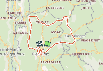
Trail Walking of 17.9 km to be discovered at Auvergne-Rhône-Alpes, Cantal, Pierrefort. This trail is proposed by tracegps.
Description
Circuit partant de Pierrefort (15), très facile, chemin en sable et petits cailloux, quelques petites routes à traverser, des bois (Chabridet et Montrosier), chemin bien large, on ne peut pas le perdre.
Positioning
Country:
France
Region :
Auvergne-Rhône-Alpes
Department/Province :
Cantal
Municipality :
Pierrefort
Location:
Unknown
Start:(Dec)
Start:(UTM)
487608 ; 4974590 (31T) N.
Comments
Trails nearby
![Trail Equestrian Pierrefort - Pierrefort - Montrosier - Chabridet - Photo](https://media.geolcdn.com/t/375/260/ext.jpg?maxdim=2&url=https%3A%2F%2Fservices.sitytrail.com%2FGeolivesWS%2FDownloadMedia.ashx%3FTrailID%3D105993%26Media%3D10111_2.jpg)
![Equestrian Equestrian](https://static1.geolcdn.com/sitytour/trail-icons/300.png)
Pierrefort - Montrosier - Chabridet
Equestrian
Medium
Pierrefort,
Auvergne-Rhône-Alpes,
Cantal,
France
![](/images/other/stat-length.png)
17.9 km | 23 km-effort
3h 0min
![](https://static1.geolcdn.com/siteimages/upload/files/16400158638029165_repeat_loop_refresh_sync_direction_icon.png)
Yes
![Trail Mountain bike Pierrefort - Pierrefort - Montrosier - Chabridet - Photo](https://media.geolcdn.com/t/375/260/ext.jpg?maxdim=2&url=https%3A%2F%2Fservices.sitytrail.com%2FGeolivesWS%2FDownloadMedia.ashx%3FTrailID%3D105992%26Media%3D10111_2.jpg)
![Mountain bike Mountain bike](https://static1.geolcdn.com/sitytour/trail-icons/202.png)
Pierrefort - Montrosier - Chabridet
Mountain bike
Medium
Pierrefort,
Auvergne-Rhône-Alpes,
Cantal,
France
![](/images/other/stat-length.png)
17.9 km | 23 km-effort
1h 30min
![](https://static1.geolcdn.com/siteimages/upload/files/16400158638029165_repeat_loop_refresh_sync_direction_icon.png)
Yes
![Trail Walking Pierrefort - Vezou (Faverolles-Boussac) - Photo](https://media.geolcdn.com/t/375/260/ext.jpg?maxdim=2&url=https%3A%2F%2Fstatic1.geolcdn.com%2Fsiteimages%2Fupload%2Ffiles%2F1553511878bg_sport_marche.png)
![Walking Walking](https://static1.geolcdn.com/sitytour/trail-icons/101.png)
Vezou (Faverolles-Boussac)
Walking
Very easy
Pierrefort,
Auvergne-Rhône-Alpes,
Cantal,
France
![](/images/other/stat-length.png)
13.2 km | 18.5 km-effort
3h 51min
![](https://static1.geolcdn.com/siteimages/upload/files/16400158638029165_repeat_loop_refresh_sync_direction_icon.png)
No
![Trail Walking Neuvéglise-sur-Truyère - La Roche Recoules - Photo](https://media.geolcdn.com/t/375/260/ext.jpg?maxdim=2&url=https%3A%2F%2Fstatic1.geolcdn.com%2Fsiteimages%2Fupload%2Ffiles%2F1553511878bg_sport_marche.png)
![Walking Walking](https://static1.geolcdn.com/sitytour/trail-icons/101.png)
La Roche Recoules
Walking
Very easy
Neuvéglise-sur-Truyère,
Auvergne-Rhône-Alpes,
Cantal,
France
![](/images/other/stat-length.png)
5 km | 6.7 km-effort
1h 51min
![](https://static1.geolcdn.com/siteimages/upload/files/16400158638029165_repeat_loop_refresh_sync_direction_icon.png)
Yes
![Trail Walking Pierrefort - le colombier le théron - Photo](https://media.geolcdn.com/t/375/260/ext.jpg?maxdim=2&url=https%3A%2F%2Fstatic1.geolcdn.com%2Fsiteimages%2Fupload%2Ffiles%2F1553511878bg_sport_marche.png)
![Walking Walking](https://static1.geolcdn.com/sitytour/trail-icons/101.png)
le colombier le théron
Walking
Very easy
Pierrefort,
Auvergne-Rhône-Alpes,
Cantal,
France
![](/images/other/stat-length.png)
4.4 km | 5.8 km-effort
1h 30min
![](https://static1.geolcdn.com/siteimages/upload/files/16400158638029165_repeat_loop_refresh_sync_direction_icon.png)
Yes
![Trail Walking Pierrefort - Le Monteil-Turlande - Photo](https://media.geolcdn.com/t/375/260/ext.jpg?maxdim=2&url=https%3A%2F%2Fstatic1.geolcdn.com%2Fsiteimages%2Fupload%2Ffiles%2F1553511878bg_sport_marche.png)
![Walking Walking](https://static1.geolcdn.com/sitytour/trail-icons/101.png)
Le Monteil-Turlande
Walking
Very easy
Pierrefort,
Auvergne-Rhône-Alpes,
Cantal,
France
![](/images/other/stat-length.png)
5.7 km | 6.6 km-effort
1h 24min
![](https://static1.geolcdn.com/siteimages/upload/files/16400158638029165_repeat_loop_refresh_sync_direction_icon.png)
No
![Trail Walking Neuvéglise-sur-Truyère - laroche champs - Photo](https://media.geolcdn.com/t/375/260/ext.jpg?maxdim=2&url=https%3A%2F%2Fstatic1.geolcdn.com%2Fsiteimages%2Fupload%2Ffiles%2F1553511878bg_sport_marche.png)
![Walking Walking](https://static1.geolcdn.com/sitytour/trail-icons/101.png)
laroche champs
Walking
Easy
Neuvéglise-sur-Truyère,
Auvergne-Rhône-Alpes,
Cantal,
France
![](/images/other/stat-length.png)
3.6 km | 5 km-effort
1h 25min
![](https://static1.geolcdn.com/siteimages/upload/files/16400158638029165_repeat_loop_refresh_sync_direction_icon.png)
Yes
![Trail Walking Paulhenc - la garde-estradié - Photo](https://media.geolcdn.com/t/375/260/ext.jpg?maxdim=2&url=https%3A%2F%2Fstatic1.geolcdn.com%2Fsiteimages%2Fupload%2Ffiles%2F1553511878bg_sport_marche.png)
![Walking Walking](https://static1.geolcdn.com/sitytour/trail-icons/101.png)
la garde-estradié
Walking
Easy
Paulhenc,
Auvergne-Rhône-Alpes,
Cantal,
France
![](/images/other/stat-length.png)
2.8 km | 3.6 km-effort
59min
![](https://static1.geolcdn.com/siteimages/upload/files/16400158638029165_repeat_loop_refresh_sync_direction_icon.png)
No
![Trail Electric bike Saint-Martin-sous-Vigouroux - 6_280423 - Photo](https://media.geolcdn.com/t/375/260/ext.jpg?maxdim=2&url=https%3A%2F%2Fstatic1.geolcdn.com%2Fsiteimages%2Fupload%2Ffiles%2F1524743154velo.jpg)
![Electric bike Electric bike](https://static1.geolcdn.com/sitytour/trail-icons/205.png)
6_280423
Electric bike
Difficult
Saint-Martin-sous-Vigouroux,
Auvergne-Rhône-Alpes,
Cantal,
France
![](/images/other/stat-length.png)
71 km | 90 km-effort
10h 6min
![](https://static1.geolcdn.com/siteimages/upload/files/16400158638029165_repeat_loop_refresh_sync_direction_icon.png)
No