Trail Walking Sainte-Juliette-sur-Viaur - Ste Juliette sur Viaur -  Vallée du Viaur - Photo

Ste Juliette sur Viaur - Vallée du Viaur

 tracegps
tracegps

User

© OpenStreetMap contributors
Length
Length
8.4 km
Max alt
Max alt
614 m
Uphill gradient
Uphill gradient
311 m
Km-Effort
Km-Effort  
12.6 km
Min alt
Min alt
440 m
Downhill gradient
Downhill gradient
311 m
Boucle
Boucle
Yes
Creation date :
2014-12-10 00:00:00.0
Updated on :
2014-12-10 00:00:00.0

(0 Reviews)

Walking
Walking
3h30
Difficulty : Medium

Scan this QR Code to open this trail in the SityTrail application

FREE GPS app for hiking

Logo SityTrail SityTrail

IGN / Geographical institutes

Download SityTrail from the App Store Download SityTrail from Google Play

Logo SityTrail SityTrail World

The world is yours!

Download SityTrail from the App Store Download SityTrail from Google Play Download SityTrail on Huawei AppGallery

About

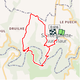
Trail Walking of 8.4 km to be discovered at Occitania, Aveyron, Sainte-Juliette-sur-Viaur. This trail is proposed by tracegps.

Description

Départ du Village Ste JULIETTE S/VIAUR. Au sud, descendre, à travers bois, dans la Vallée du VIAUR, le traverser sur une passerelle et remonter sur l'autre versant jusqu'à RECOULES. Revenir,à nouveau dans la Vallée jusqu'au VIAUR, après l'avoir traversé sur une autre passerelle, remonter, par un magnifique sentier jusqu'à GARY et rejoindre le point de départ Ste JULIETTE.

Elevation profile

Photos

Positioning

Country:
France
Region :
Occitania
Department/Province :
Aveyron
Municipality :
Sainte-Juliette-sur-Viaur
Location:
Unknown
Start:(UTM)
461761 ; 4895799 (31T) N.

Trails nearby

Trail Walking Salmiech - Salmiech, Rocher de Peyrelevade  - Photo
Walking
tracegps

Walking

Medium
Salmiech, Occitania, Aveyron, France
9.9 km | 13 km-effort
2h 45min
Yes
Trail Walking Manhac - Manhac, au coeur du Ségala - Photo
Walking
tracegps

Walking

Medium
(1)
Manhac, Occitania, Aveyron, France
11.3 km | 16.1 km-effort
3h 0min
Yes
Trail Walking Comps-la-Grand-Ville - Abbaye de Bonnecombe via Comps La Grand Ville - Photo
Walking
tercla

Walking

Very difficult
Comps-la-Grand-Ville, Occitania, Aveyron, France
21 km | 27 km-effort
6h 18min
Yes
Trail sport Comps-la-Grand-Ville - Pont de Grandfuel - Versailles - Photo
sport
Sébastien LANDEAU

sport

Very easy
Comps-la-Grand-Ville, Occitania, Aveyron, France
13.9 km | 18.8 km-effort
Unknown
No
Trail Walking Sainte-Juliette-sur-Viaur - st Juliette  - Photo
Walking
Pascal Lemaire

Walking

Very difficult
Sainte-Juliette-sur-Viaur, Occitania, Aveyron, France
13.6 km | 21 km-effort
4h 22min
Yes
Trail Walking Salmiech - Salmiech  - Photo
Walking
yvesmonteillet

Walking

Difficult
Salmiech, Occitania, Aveyron, France
10.6 km | 14 km-effort
2h 1min
Yes
Trail Motor Calmont - rieupeyroux 2018 - Photo
Motor
frank12

Motor

Very easy
Calmont, Occitania, Aveyron, France
93 km | 129 km-effort
2h 30min
No
Trail Motor Calmont - rieupeyroux 2018 - Photo
Motor
frank12

Motor

Very easy
Calmont, Occitania, Aveyron, France
93 km | 129 km-effort
2h 30min
No
Trail Walking Cassagnes-Bégonhès - viaur - Photo
Walking
bouscaillou

Walking

Very easy
Cassagnes-Bégonhès, Occitania, Aveyron, France
2.3 km | 4 km-effort
58min
No


Close
My subscriptions