![](/images/other/stat-length.png)
![Trail Walking Sangatte - Les Noires Mottes - Sangatte - Photo](https://media.geolcdn.com/t/1900/400/ext.pjpeg?maxdim=2&url=https%3A%2F%2Fservices.sitytrail.com%2FGeolivesWS%2FDownloadMedia.ashx%3FTrailID%3D105835%26Media%3D9798_1.jpg)
Les Noires Mottes - Sangatte
tracegps
User
![Length](/images/other/stat-length.png)
Length
19.6 km
![Max alt](https://static1.geolcdn.com/siteimages/upload/files/1508320355ic_sort_altitude_max_24dp.png)
Max alt
143 m
![Uphill gradient](https://static1.geolcdn.com/siteimages/upload/files/1508320355ic_sort_den_pos_24dp.png)
Uphill gradient
407 m
![Km-Effort](/images/other/stat-length.png)
Km-Effort
25 km
![Min alt](https://static1.geolcdn.com/siteimages/upload/files/1508320355ic_sort_altitude_min_24dp.png)
Min alt
0 m
![Downhill gradient](https://static1.geolcdn.com/siteimages/upload/files/1508320355ic_sort_den_neg_24dp.png)
Downhill gradient
407 m
![Boucle](https://static1.geolcdn.com/siteimages/upload/files/16400158638029165_repeat_loop_refresh_sync_direction_icon.png)
Boucle
No
Creation date :
2014-12-10 00:00:00.0
Updated on :
2014-12-10 00:00:00.0
![Walking](https://static1.geolcdn.com/sitytour/trail-icons/101.png)
4h00
Difficulty : Medium
![Scan this QR Code to open this trail in the SityTrail application](https://capi.geolives.com/qq0zvz2zws4bq2lad0pu/sitytour/trails/105835/qr.png?size=200)
FREE GPS app for hiking
About
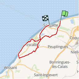
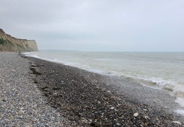
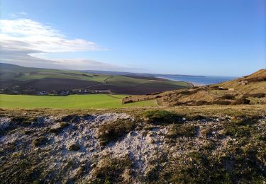
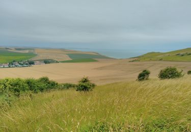
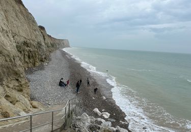
Trail Walking of 19.6 km to be discovered at Hauts-de-France, Pas-de-Calais, Sangatte. This trail is proposed by tracegps.
Description
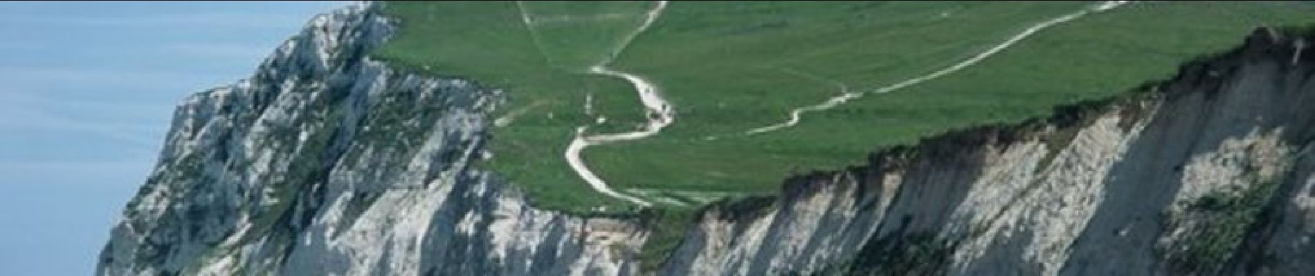
Parcours qui emprunte les nombreux petits chemins qui serpentent le site naturel des Noires Mottes au dessus de Sangatte et du Cap Blanc-Nez.
Positioning
Country:
France
Region :
Hauts-de-France
Department/Province :
Pas-de-Calais
Municipality :
Sangatte
Location:
Unknown
Start:(Dec)
Start:(UTM)
413969 ; 5645211 (31U) N.
Comments
Trails nearby
![Trail Walking Escalles - Les balcons d'Escalles - Photo](https://media.geolcdn.com/t/375/260/ext.jpg?maxdim=2&url=https%3A%2F%2Fservices.sitytrail.com%2FGeolivesWS%2FDownloadMedia.ashx%3FTrailID%3D110282%26Media%3D5677_6.jpg)
![Walking Walking](https://static1.geolcdn.com/sitytour/trail-icons/101.png)
Les balcons d'Escalles
Walking
Medium
(5)
Escalles,
Hauts-de-France,
Pas-de-Calais,
France
![](/images/other/stat-length.png)
7.8 km | 10.5 km-effort
2h 0min
![](https://static1.geolcdn.com/siteimages/upload/files/16400158638029165_repeat_loop_refresh_sync_direction_icon.png)
Yes
![Trail Walking Sangatte - Le Site des 2 Caps - Les Falaises du Cap Blanc Nez et le Mont d'Hubert - Photo](https://media.geolcdn.com/t/375/260/ext.jpg?maxdim=2&url=https%3A%2F%2Fservices.sitytrail.com%2FGeolivesWS%2FDownloadMedia.ashx%3FTrailID%3D109468%26Media%3D4011_6.jpg)
![Walking Walking](https://static1.geolcdn.com/sitytour/trail-icons/101.png)
Le Site des 2 Caps - Les Falaises du Cap Blanc Nez et le Mont d'Hubert
Walking
Medium
(3)
Sangatte,
Hauts-de-France,
Pas-de-Calais,
France
![](/images/other/stat-length.png)
11.2 km | 14.7 km-effort
3h 0min
![](https://static1.geolcdn.com/siteimages/upload/files/16400158638029165_repeat_loop_refresh_sync_direction_icon.png)
Yes
![Trail Walking Sangatte - Le Site des 2 Caps - Les Falaises du Cap Blanc Nez et le Mont d'Hubert - Photo](https://media.geolcdn.com/t/375/260/ext.jpg?maxdim=2&url=https%3A%2F%2Fstatic1.geolcdn.com%2Fsiteimages%2Fupload%2Ffiles%2F1553511878bg_sport_marche.png)
![Walking Walking](https://static1.geolcdn.com/sitytour/trail-icons/101.png)
Le Site des 2 Caps - Les Falaises du Cap Blanc Nez et le Mont d'Hubert
Walking
Easy
(4)
Sangatte,
Hauts-de-France,
Pas-de-Calais,
France
![](/images/other/stat-length.png)
11.2 km | 14.7 km-effort
2h 50min
![](https://static1.geolcdn.com/siteimages/upload/files/16400158638029165_repeat_loop_refresh_sync_direction_icon.png)
Yes
![Trail Walking Escalles - ⛺️ Les Érables - Cap Blanc-Nez - Photo](https://media.geolcdn.com/t/375/260/4ecc3ab4-bceb-4584-bd93-230747ad2605.jpg&format=jpg&maxdim=2)
![Walking Walking](https://static1.geolcdn.com/sitytour/trail-icons/101.png)
⛺️ Les Érables - Cap Blanc-Nez
Walking
Medium
Escalles,
Hauts-de-France,
Pas-de-Calais,
France
![](/images/other/stat-length.png)
6.9 km | 9.3 km-effort
1h 53min
![](https://static1.geolcdn.com/siteimages/upload/files/16400158638029165_repeat_loop_refresh_sync_direction_icon.png)
Yes
![Trail Walking Sangatte - Cap Blanc Nez - Photo](https://media.geolcdn.com/t/375/260/620a253a-d967-4e18-ac2d-409afd338c62.jpg&format=jpg&maxdim=2)
![Walking Walking](https://static1.geolcdn.com/sitytour/trail-icons/101.png)
Cap Blanc Nez
Walking
Easy
Sangatte,
Hauts-de-France,
Pas-de-Calais,
France
![](/images/other/stat-length.png)
6.7 km | 8.8 km-effort
1h 36min
![](https://static1.geolcdn.com/siteimages/upload/files/16400158638029165_repeat_loop_refresh_sync_direction_icon.png)
Yes
![Trail Walking Escalles - Sangatte jours 2 - Photo](https://media.geolcdn.com/t/375/260/9ea72cd3-a648-4be8-88ec-3d913bc95911.jpg&format=jpg&maxdim=2)
![Walking Walking](https://static1.geolcdn.com/sitytour/trail-icons/101.png)
Sangatte jours 2
Walking
Medium
Escalles,
Hauts-de-France,
Pas-de-Calais,
France
![](/images/other/stat-length.png)
8.3 km | 10.9 km-effort
1h 42min
![](https://static1.geolcdn.com/siteimages/upload/files/16400158638029165_repeat_loop_refresh_sync_direction_icon.png)
No
![Trail Walking Sangatte - Le Cap Blanc-Nez et les hauts de Sangatte - Photo](https://media.geolcdn.com/t/375/260/55b9ffed-0c3c-4e17-b124-ad9ca4783a4f.jpg&format=jpg&maxdim=2)
![Walking Walking](https://static1.geolcdn.com/sitytour/trail-icons/101.png)
Le Cap Blanc-Nez et les hauts de Sangatte
Walking
Easy
(4)
Sangatte,
Hauts-de-France,
Pas-de-Calais,
France
![](/images/other/stat-length.png)
7 km | 9.1 km-effort
2h 15min
![](https://static1.geolcdn.com/siteimages/upload/files/16400158638029165_repeat_loop_refresh_sync_direction_icon.png)
Yes
![Trail Walking Sangatte - CANI-RADO TOUR (boucle Cap Blanc nez) - Photo](https://media.geolcdn.com/t/375/260/4937a010-2b80-4292-a3b1-bc4cc7ac7e06.jpg&format=jpg&maxdim=2)
![Walking Walking](https://static1.geolcdn.com/sitytour/trail-icons/101.png)
CANI-RADO TOUR (boucle Cap Blanc nez)
Walking
Medium
Sangatte,
Hauts-de-France,
Pas-de-Calais,
France
![](/images/other/stat-length.png)
19 km | 23 km-effort
5h 45min
![](https://static1.geolcdn.com/siteimages/upload/files/16400158638029165_repeat_loop_refresh_sync_direction_icon.png)
Yes
![Trail Walking Escalles - Cap Blanc Nez-Wissant-mont de Couple 25 km - Photo](https://media.geolcdn.com/t/375/260/fcd56ec8-a107-46c9-b8ce-7618ca7048cf.jpg&format=jpg&maxdim=2)
![Walking Walking](https://static1.geolcdn.com/sitytour/trail-icons/101.png)
Cap Blanc Nez-Wissant-mont de Couple 25 km
Walking
Medium
Escalles,
Hauts-de-France,
Pas-de-Calais,
France
![](/images/other/stat-length.png)
25 km | 31 km-effort
7h 16min
![](https://static1.geolcdn.com/siteimages/upload/files/16400158638029165_repeat_loop_refresh_sync_direction_icon.png)
Yes
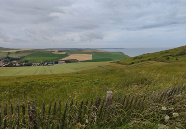
super parcours avec des vues magnifiques...