![](/images/other/stat-length.png)
![Trail Mountain bike Chalain-d'Uzore - VTT Chalain d'Uzore - 8ème Croix d'automne - Photo](https://media.geolcdn.com/t/1900/400/ext.pjpeg?maxdim=2&url=https%3A%2F%2Fservices.sitytrail.com%2FGeolivesWS%2FDownloadMedia.ashx%3FTrailID%3D105801%26Media%3D9714_6.jpg)
VTT Chalain d'Uzore - 8ème Croix d'automne
tracegps
User
![Length](/images/other/stat-length.png)
![Max alt](https://static1.geolcdn.com/siteimages/upload/files/1508320355ic_sort_altitude_max_24dp.png)
![Uphill gradient](https://static1.geolcdn.com/siteimages/upload/files/1508320355ic_sort_den_pos_24dp.png)
![Km-Effort](/images/other/stat-length.png)
![Min alt](https://static1.geolcdn.com/siteimages/upload/files/1508320355ic_sort_altitude_min_24dp.png)
![Downhill gradient](https://static1.geolcdn.com/siteimages/upload/files/1508320355ic_sort_den_neg_24dp.png)
![Boucle](https://static1.geolcdn.com/siteimages/upload/files/16400158638029165_repeat_loop_refresh_sync_direction_icon.png)
![Mountain bike](https://static1.geolcdn.com/sitytour/trail-icons/202.png)
5h00
Difficulty : Very difficult
![Scan this QR Code to open this trail in the SityTrail application](https://capi.geolives.com/qq0zvz2zws4bq2lad0pu/sitytour/trails/105801/qr.png?size=200)
FREE GPS app for hiking
About
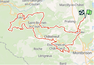
Trail Mountain bike of 67 km to be discovered at Auvergne-Rhône-Alpes, Loire, Chalain-d'Uzore. This trail is proposed by tracegps.
Description
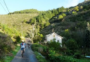
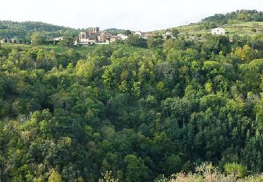
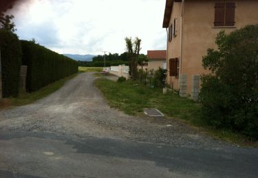
Chalain d'Uzore - Parking et départ de la salle des fêtes. Cette randonnée VTT appelée "Les Croix d'automne" est organisée chaque année par les "Amis du Vélo" de Chalain d'Uzore et se déroule le 4ème samedi du mois d'octobre (trace du samedi 23 octobre 2010). Ce parcours dans les Monts du Forez est ardu et technique mais de toute beauté. Vos efforts seront récompensés par la splendeur des paysages. Vous passerez d'un vallon à l'autre tantôt en longeant un torrent agité et bruyant dans une étroite vallée, tantôt en traversant de belles forêts de résineux. Au détour d'un virage, vous apercevrez une cascade, traverserez de beaux villages perchés dans la montagne, longerez des près où broutent les vaches et vous continuerez à grimper pour atteindre une altitude maxi de 1130 m. Fin de la boucle par une belle dégringolade (frissons garantis) vers Champdieu que vous traverserez, puis retour au calme dans la plaine du Forez jusqu'à la salle des fêtes de Chalain d’Uzore. Topoguides : Randonnée Pédestre - Le Haut Forez ; Randonnée Pédestre - Forez entre Loire et Crêtes (à pied et à VTT) ; Randonnée Pédestre - Les Monts du Forez.
Positioning
Comments
Trails nearby
![Trail Walking Champdieu - Randonnée sur les hauteurs de Champdieu - Photo](https://media.geolcdn.com/t/375/260/ea48d69b-ff5a-4a85-96d8-226e11083980.jpg&format=jpg&maxdim=2)
![Walking Walking](https://static1.geolcdn.com/sitytour/trail-icons/101.png)
Walking
![](/images/other/stat-length.png)
![](https://static1.geolcdn.com/siteimages/upload/files/16400158638029165_repeat_loop_refresh_sync_direction_icon.png)
![Trail Walking Montverdun - Randonnée autour de Montverdun - Photo](https://media.geolcdn.com/t/375/260/64d529f3-750c-4edd-b848-97cd9687592e.jpg&format=jpg&maxdim=2)
![Walking Walking](https://static1.geolcdn.com/sitytour/trail-icons/101.png)
Walking
![](/images/other/stat-length.png)
![](https://static1.geolcdn.com/siteimages/upload/files/16400158638029165_repeat_loop_refresh_sync_direction_icon.png)
![Trail Walking Marcilly-le-Châtel - Marcillyvers Goutteras - Photo](https://media.geolcdn.com/t/375/260/ext.jpg?maxdim=2&url=https%3A%2F%2Fstatic1.geolcdn.com%2Fsiteimages%2Fupload%2Ffiles%2F1553511878bg_sport_marche.png)
![Walking Walking](https://static1.geolcdn.com/sitytour/trail-icons/101.png)
Walking
![](/images/other/stat-length.png)
![](https://static1.geolcdn.com/siteimages/upload/files/16400158638029165_repeat_loop_refresh_sync_direction_icon.png)
![Trail Mountain bike Chalain-d'Uzore - 11ème Croix d'Automne (2013-VTT-50km) - Chalain d'Uzore - Photo](https://media.geolcdn.com/t/375/260/ext.jpg?maxdim=2&url=https%3A%2F%2Fservices.sitytrail.com%2FGeolivesWS%2FDownloadMedia.ashx%3FTrailID%3D317102%26Media%3D16250_6.jpg)
![Mountain bike Mountain bike](https://static1.geolcdn.com/sitytour/trail-icons/202.png)
Mountain bike
![](/images/other/stat-length.png)
![](https://static1.geolcdn.com/siteimages/upload/files/16400158638029165_repeat_loop_refresh_sync_direction_icon.png)
![Trail Mountain bike Chalain-d'Uzore - 10ème Croix d'Automne (2012-VTT-70km) - Chalain d'Uzore - Photo](https://media.geolcdn.com/t/375/260/ext.jpg?maxdim=2&url=https%3A%2F%2Fservices.sitytrail.com%2FGeolivesWS%2FDownloadMedia.ashx%3FTrailID%3D172893%26Media%3D14352_6.jpg)
![Mountain bike Mountain bike](https://static1.geolcdn.com/sitytour/trail-icons/202.png)
Mountain bike
![](/images/other/stat-length.png)
![](https://static1.geolcdn.com/siteimages/upload/files/16400158638029165_repeat_loop_refresh_sync_direction_icon.png)
![Trail Mountain bike Champdieu - Champdieu - La Grande Tentative VTT - Photo](https://media.geolcdn.com/t/375/260/ext.jpg?maxdim=2&url=https%3A%2F%2Fservices.sitytrail.com%2FGeolivesWS%2FDownloadMedia.ashx%3FTrailID%3D105629%26Media%3D9406_6.jpg)
![Mountain bike Mountain bike](https://static1.geolcdn.com/sitytour/trail-icons/202.png)
Mountain bike
![](/images/other/stat-length.png)
![](https://static1.geolcdn.com/siteimages/upload/files/16400158638029165_repeat_loop_refresh_sync_direction_icon.png)
![Trail Other activity Champdieu - Vaugirard 10.09.17 - Photo](https://media.geolcdn.com/t/375/260/ext.jpg?maxdim=2&url=https%3A%2F%2Fservices.sitytrail.com%2FGeolivesWS%2FDownloadMedia.ashx%3FTrailID%3D827752%26Media%3Dfix__20170910181154.jpg)
![Other activity Other activity](https://static1.geolcdn.com/sitytour/trail-icons/900.png)
Other activity
![](/images/other/stat-length.png)
![](https://static1.geolcdn.com/siteimages/upload/files/16400158638029165_repeat_loop_refresh_sync_direction_icon.png)
![Trail Walking Mornand-en-Forez - Mornand le Moulin - Photo](https://media.geolcdn.com/t/375/260/ext.jpg?maxdim=2&url=https%3A%2F%2Fservices.sitytrail.com%2FGeolivesWS%2FDownloadMedia.ashx%3FTrailID%3D343705%26Media%3D20140603152022.jpg)
![Walking Walking](https://static1.geolcdn.com/sitytour/trail-icons/101.png)
Walking
![](/images/other/stat-length.png)
![](https://static1.geolcdn.com/siteimages/upload/files/16400158638029165_repeat_loop_refresh_sync_direction_icon.png)
![Trail Mountain bike Mornand-en-Forez - t - Photo](https://media.geolcdn.com/t/375/260/ext.jpg?maxdim=2&url=https%3A%2F%2Fstatic1.geolcdn.com%2Fsiteimages%2Fupload%2Ffiles%2F1524743154velo.jpg)
![Mountain bike Mountain bike](https://static1.geolcdn.com/sitytour/trail-icons/202.png)
Mountain bike
![](/images/other/stat-length.png)
![](https://static1.geolcdn.com/siteimages/upload/files/16400158638029165_repeat_loop_refresh_sync_direction_icon.png)