![](/images/other/stat-length.png)
![Trail Mountain bike Saint-Dié-des-Vosges - Le Kemberg à VTT - St Die des Vosges - Photo](https://media.geolcdn.com/t/1900/400/ext.pjpeg?maxdim=2&url=https%3A%2F%2Fstatic1.geolcdn.com%2Fsiteimages%2Fupload%2Ffiles%2F1524743154velo.jpg)
Le Kemberg à VTT - St Die des Vosges
tracegps
User
![Length](/images/other/stat-length.png)
Length
21 km
![Max alt](https://static1.geolcdn.com/siteimages/upload/files/1508320355ic_sort_altitude_max_24dp.png)
Max alt
688 m
![Uphill gradient](https://static1.geolcdn.com/siteimages/upload/files/1508320355ic_sort_den_pos_24dp.png)
Uphill gradient
692 m
![Km-Effort](/images/other/stat-length.png)
Km-Effort
30 km
![Min alt](https://static1.geolcdn.com/siteimages/upload/files/1508320355ic_sort_altitude_min_24dp.png)
Min alt
405 m
![Downhill gradient](https://static1.geolcdn.com/siteimages/upload/files/1508320355ic_sort_den_neg_24dp.png)
Downhill gradient
692 m
![Boucle](https://static1.geolcdn.com/siteimages/upload/files/16400158638029165_repeat_loop_refresh_sync_direction_icon.png)
Boucle
Yes
Creation date :
2014-12-10 00:00:00.0
Updated on :
2014-12-10 00:00:00.0
![Mountain bike](https://static1.geolcdn.com/sitytour/trail-icons/202.png)
2h00
Difficulty : Difficult
![Scan this QR Code to open this trail in the SityTrail application](https://capi.geolives.com/qq0zvz2zws4bq2lad0pu/sitytour/trails/105751/qr.png?size=200)
FREE GPS app for hiking
About
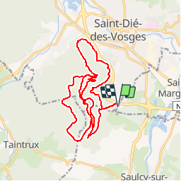
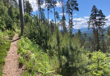
Trail Mountain bike of 21 km to be discovered at Grand Est, Vosges, Saint-Dié-des-Vosges. This trail is proposed by tracegps.
Description
Un parcours typé "All mountain" de 20Km. On monte progressivement par de larges routes forestières, les descentes, quant à elles se font par de petit "single" qui peuvent êtres assez techniques. On s’amuse vraiment sur ce circuit avec un VTT tout suspendu.
Positioning
Country:
France
Region :
Grand Est
Department/Province :
Vosges
Municipality :
Saint-Dié-des-Vosges
Location:
Unknown
Start:(Dec)
Start:(UTM)
347707 ; 5347476 (32U) N.
Comments
Trails nearby
![Trail Walking Saint-Michel-sur-Meurthe - massif de la madeleine - Photo](https://media.geolcdn.com/t/375/260/ext.jpg?maxdim=2&url=https%3A%2F%2Fservices.sitytrail.com%2FGeolivesWS%2FDownloadMedia.ashx%3FTrailID%3D1148232%26Media%3D20190421153638.jpg)
![Walking Walking](https://static1.geolcdn.com/sitytour/trail-icons/101.png)
massif de la madeleine
Walking
Medium
(1)
Saint-Michel-sur-Meurthe,
Grand Est,
Vosges,
France
![](/images/other/stat-length.png)
14.7 km | 22 km-effort
4h 10min
![](https://static1.geolcdn.com/siteimages/upload/files/16400158638029165_repeat_loop_refresh_sync_direction_icon.png)
Yes
![Trail On foot Taintrux - GR de Pays de Déodatie - Photo](https://media.geolcdn.com/t/375/260/8c9d86c2-6a8a-421f-b627-7552051e9313.jpeg&format=jpg&maxdim=2)
![On foot On foot](https://static1.geolcdn.com/sitytour/trail-icons/100.png)
GR de Pays de Déodatie
On foot
Easy
Taintrux,
Grand Est,
Vosges,
France
![](/images/other/stat-length.png)
7.9 km | 12.5 km-effort
2h 49min
![](https://static1.geolcdn.com/siteimages/upload/files/16400158638029165_repeat_loop_refresh_sync_direction_icon.png)
No
![Trail Walking Saint-Dié-des-Vosges - 2019-03-07 Marche Montée des Schlitteurs - Photo](https://media.geolcdn.com/t/375/260/b6c7faad-e93b-4a65-8c3b-cd428aea5e79.jpg&format=jpg&maxdim=2)
![Walking Walking](https://static1.geolcdn.com/sitytour/trail-icons/101.png)
2019-03-07 Marche Montée des Schlitteurs
Walking
Very easy
Saint-Dié-des-Vosges,
Grand Est,
Vosges,
France
![](/images/other/stat-length.png)
11.3 km | 19.6 km-effort
4h 35min
![](https://static1.geolcdn.com/siteimages/upload/files/16400158638029165_repeat_loop_refresh_sync_direction_icon.png)
Yes
![Trail Walking Taintrux - suuntoapp-Hiking-2024-05-10T08-54-36Z - Photo](https://media.geolcdn.com/t/375/260/9fe93acc-f8ea-40c3-b435-6f108f3a2d6d.jpg&format=jpg&maxdim=2)
![Walking Walking](https://static1.geolcdn.com/sitytour/trail-icons/101.png)
suuntoapp-Hiking-2024-05-10T08-54-36Z
Walking
Medium
Taintrux,
Grand Est,
Vosges,
France
![](/images/other/stat-length.png)
18.8 km | 32 km-effort
7h 14min
![](https://static1.geolcdn.com/siteimages/upload/files/16400158638029165_repeat_loop_refresh_sync_direction_icon.png)
No
![Trail Walking Saint-Dié-des-Vosges - Massif de l'Ormont et ses rochers remarquables - Photo](https://media.geolcdn.com/t/375/260/5bfc527b-060c-4d01-aae8-b360a5c8e4f1.jpg&format=jpg&maxdim=2)
![Walking Walking](https://static1.geolcdn.com/sitytour/trail-icons/101.png)
Massif de l'Ormont et ses rochers remarquables
Walking
Very difficult
Saint-Dié-des-Vosges,
Grand Est,
Vosges,
France
![](/images/other/stat-length.png)
15.9 km | 25 km-effort
5h 38min
![](https://static1.geolcdn.com/siteimages/upload/files/16400158638029165_repeat_loop_refresh_sync_direction_icon.png)
Yes
![Trail Walking Saulcy-sur-Meurthe - Massif du KEMBERG - Photo](https://media.geolcdn.com/t/375/260/a0e83b61-8364-418a-96af-6be211e18cd3.jpg&format=jpg&maxdim=2)
![Walking Walking](https://static1.geolcdn.com/sitytour/trail-icons/101.png)
Massif du KEMBERG
Walking
Very difficult
Saulcy-sur-Meurthe,
Grand Est,
Vosges,
France
![](/images/other/stat-length.png)
12.6 km | 20 km-effort
4h 45min
![](https://static1.geolcdn.com/siteimages/upload/files/16400158638029165_repeat_loop_refresh_sync_direction_icon.png)
Yes
![Trail Walking Taintrux - Marche 09-07-22 18Km - Photo](https://media.geolcdn.com/t/375/260/dffd94f9-cf6a-45ad-8857-0cc31d7aeb13.jpg&format=jpg&maxdim=2)
![Walking Walking](https://static1.geolcdn.com/sitytour/trail-icons/101.png)
Marche 09-07-22 18Km
Walking
Difficult
Taintrux,
Grand Est,
Vosges,
France
![](/images/other/stat-length.png)
15.4 km | 24 km-effort
4h 13min
![](https://static1.geolcdn.com/siteimages/upload/files/16400158638029165_repeat_loop_refresh_sync_direction_icon.png)
Yes
![Trail Walking Taintrux - Marche 06-06-22 24km - Photo](https://media.geolcdn.com/t/375/260/0cc2cfac-96ee-423b-8767-12701e4ef6de.jpg&format=jpg&maxdim=2)
![Walking Walking](https://static1.geolcdn.com/sitytour/trail-icons/101.png)
Marche 06-06-22 24km
Walking
Difficult
Taintrux,
Grand Est,
Vosges,
France
![](/images/other/stat-length.png)
23 km | 32 km-effort
5h 48min
![](https://static1.geolcdn.com/siteimages/upload/files/16400158638029165_repeat_loop_refresh_sync_direction_icon.png)
Yes
![Trail Walking Taintrux - Marche 25-05-22 18Km Climont - Photo](https://media.geolcdn.com/t/375/260/3f6a4b19-ce20-42f2-b08d-3fcf1fa7acba.jpg&format=jpg&maxdim=2)
![Walking Walking](https://static1.geolcdn.com/sitytour/trail-icons/101.png)
Marche 25-05-22 18Km Climont
Walking
Difficult
Taintrux,
Grand Est,
Vosges,
France
![](/images/other/stat-length.png)
16 km | 27 km-effort
4h 50min
![](https://static1.geolcdn.com/siteimages/upload/files/16400158638029165_repeat_loop_refresh_sync_direction_icon.png)
Yes