Trail Walking Loison - Chemin de Forbeuvillers - Loison - Photo

Chemin de Forbeuvillers - Loison

 tracegps
tracegps

User

© OpenStreetMap contributors
Length
Length
12.3 km
Max alt
Max alt
256 m
Uphill gradient
Uphill gradient
88 m
Km-Effort
Km-Effort  
13.5 km
Min alt
Min alt
220 m
Downhill gradient
Downhill gradient
88 m
Boucle
Boucle
Yes
Creation date :
2014-12-10 00:00:00.0
Updated on :
2014-12-10 00:00:00.0

(0 Reviews)

Walking
Walking
3h04
Difficulty : Difficult

Scan this QR Code to open this trail in the SityTrail application

FREE GPS app for hiking

Logo SityTrail SityTrail

IGN / Geographical institutes

Download SityTrail from the App Store Download SityTrail from Google Play

Logo SityTrail SityTrail World

The world is yours!

Download SityTrail from the App Store Download SityTrail from Google Play Download SityTrail on Huawei AppGallery

About

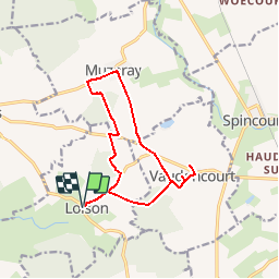
Trail Walking of 12.3 km to be discovered at Grand Est, Meuse, Loison. This trail is proposed by tracegps.

Description

Circuit proposé par la Communauté de Communes du Pays de Spincourt. Départ de l’église de Loison. Au détour des rues de Loison, on peut admirer le lavoir érigé à la source même du Loison, ainsi que l’église, ancienne forteresse qui a servi de refuge aux habitants durant la guerre de 30 ans. A Vaudoncourt vous pouvez voir la chapelle Saint-Anne qui constitue un lieu de pèlerinage et a Muzeray vous pouvez découvrir son musée permanant présentant plus de 120 crèches, vous pourrez voir aussi un château d’eau allemand, vestige de la guerre 14-18. Retrouvez les circuits de la Communauté de Communes du Pays de Spincourt.

Elevation profile

Photos

Positioning

Country:
France
Region :
Grand Est
Department/Province :
Meuse
Municipality :
Loison
Location:
Unknown
Start:(UTM)
689913 ; 5465281 (31U) N.

Trails nearby

Trail Cycle Spincourt - Le temps où l'on faillou la  Buaië - Spincourt - Photo
Cycle
tracegps

Cycle

Medium
Spincourt, Grand Est, Meuse, France
40 km | 45 km-effort
2h 15min
Yes
Trail Walking Billy-sous-Mangiennes - Du lavoir au Gué - Billy-sous-Mangiennes - Photo
Walking
tracegps

Walking

Difficult
Billy-sous-Mangiennes, Grand Est, Meuse, France
17.6 km | 19.9 km-effort
4h 25min
Yes
Trail Walking Senon - Amel_2023-04-23 - Photo
Walking
patdecosnes

Walking

Difficult
Senon, Grand Est, Meuse, France
14.5 km | 16.2 km-effort
3h 10min
Yes
Trail Walking Loison - loison champ - Photo
Walking
veroberton

Walking

Easy
Loison, Grand Est, Meuse, France
3.5 km | 3.8 km-effort
2h 30min
No
Trail Walking Senon - Amel etain - Photo
Walking
AlainQuent

Walking

Very easy
Senon, Grand Est, Meuse, France
55 km | 65 km-effort
8h 33min
No
Trail Walking Vaudoncourt - Vaudoncourt 13-02-20 - Photo
Walking
patdecosnes

Walking

Easy
Vaudoncourt, Grand Est, Meuse, France
9.9 km | 10.8 km-effort
2h 44min
Yes
Trail Walking Muzeray - Muzeray 05-12-19 - Photo
Walking
patdecosnes

Walking

Very easy
Muzeray, Grand Est, Meuse, France
10.8 km | 12.6 km-effort
3h 0min
Yes
Trail Walking Spincourt - Spincourt 03-10-19 - Photo
Walking
patdecosnes

Walking

Very easy
Spincourt, Grand Est, Meuse, France
9.9 km | 11.5 km-effort
2h 23min
Yes
Trail Walking Spincourt - spin - Photo
Walking
AlainQuent

Walking

Very easy
Spincourt, Grand Est, Meuse, France
11.5 km | 13 km-effort
2h 28min
No


Close
My subscriptions