Trail Walking Joux-la-Ville - Joux la Ville - Photo
 tracegps
tracegps

User

© OpenStreetMap contributors
Length
Length
17.5 km
Max alt
Max alt
347 m
Uphill gradient
Uphill gradient
299 m
Km-Effort
Km-Effort  
21 km
Min alt
Min alt
226 m
Downhill gradient
Downhill gradient
299 m
Boucle
Boucle
Yes
Creation date :
2014-12-10 00:00:00.0
Updated on :
2014-12-10 00:00:00.0

(0 Reviews)

Walking
Walking
6h00
Difficulty : Medium

Scan this QR Code to open this trail in the SityTrail application

FREE GPS app for hiking

Logo SityTrail SityTrail

IGN / Geographical institutes

Download SityTrail from the App Store Download SityTrail from Google Play

Logo SityTrail SityTrail World

The world is yours!

Download SityTrail from the App Store Download SityTrail from Google Play Download SityTrail on Huawei AppGallery

About

Trail Walking of 17.5 km to be discovered at Bourgogne-Franche-Comté, Yonne, Joux-la-Ville. This trail is proposed by tracegps.

Description

Randonnée à travers la forêt domaniale du Val de la Nef.

Elevation profile

Positioning

Country:
France
Region :
Bourgogne-Franche-Comté
Department/Province :
Yonne
Municipality :
Joux-la-Ville
Location:
Unknown
Start:(UTM)
564727 ; 5274673 (31T) N.

Trails nearby

Trail Walking Deux Rivières - SLV-120825-Vincelles - Cravant-Vermenton - Photo
Walking
randodan

Walking

Very easy
(1)
Deux Rivières, Bourgogne-Franche-Comté, Yonne, France
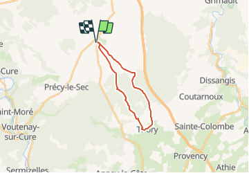
15.6 km | 17.8 km-effort
4h 40min
Yes
Trail On foot Deux Rivières - CRAVANT - Photo
On foot
JMC89

On foot

Easy
(1)
Deux Rivières, Bourgogne-Franche-Comté, Yonne, France
8 km | 9.6 km-effort
2h 11min
Yes
Trail Walking Avallon - Trek Morvan J1/5 : D'Avallon à Foissy les Vézelay - Photo
Walking
GUIDE
chessyca

Walking

Easy
Avallon, Bourgogne-Franche-Comté, Yonne, France
23 km | 28 km-effort
5h 42min
No
Trail Mountain bike Avallon - grimpette morvan 2017 - Photo
Mountain bike
Tollard

Mountain bike

Difficult
(1)
Avallon, Bourgogne-Franche-Comté, Yonne, France
53 km | 69 km-effort
3h 39min
Yes
Trail Walking Vézelay - Vezelay - Saligny mai 2017 - Photo
Walking
Decelle

Walking

Easy
(1)
Vézelay, Bourgogne-Franche-Comté, Yonne, France
19.7 km | 24 km-effort
5h 7min
No
Trail Walking Arcy-sur-Cure - arcy grottes - Photo
Walking
fabrixte

Walking

Difficult
(1)
Arcy-sur-Cure, Bourgogne-Franche-Comté, Yonne, France
11.7 km | 15.8 km-effort
3h 25min
Yes
Trail Walking Saint-Moré - Les grottes de Saint Moré - Photo
Walking
tracegps

Walking

Difficult
(1)
Saint-Moré, Bourgogne-Franche-Comté, Yonne, France
14.2 km | 18.1 km-effort
4h 0min
Yes
Trail Walking Noyers - Randonnée à Noyers sur Serein - Photo
Walking
HF89

Walking

Easy
Noyers, Bourgogne-Franche-Comté, Yonne, France
9.2 km | 11.2 km-effort
2h 41min
Yes
Trail Walking Irancy - Boucle des coteaux d 'Irancy - Photo
Walking
HF89

Walking

Easy
Irancy, Bourgogne-Franche-Comté, Yonne, France
10.5 km | 13.7 km-effort
2h 5min
Yes


Close
My subscriptions