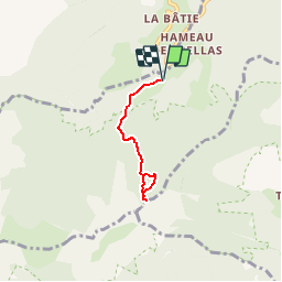
![](/images/other/stat-length.png)
![Trail Walking Saint-Michel-les-Portes - Le Rocher de Pansaret (tentative) - Photo](https://media.geolcdn.com/t/1900/400/ext.pjpeg?maxdim=2&url=https%3A%2F%2Fservices.sitytrail.com%2FGeolivesWS%2FDownloadMedia.ashx%3FTrailID%3D105612%26Media%3D9382_1.jpg)
Le Rocher de Pansaret (tentative)
tracegps
User
![Length](/images/other/stat-length.png)
![Max alt](https://static1.geolcdn.com/siteimages/upload/files/1508320355ic_sort_altitude_max_24dp.png)
![Uphill gradient](https://static1.geolcdn.com/siteimages/upload/files/1508320355ic_sort_den_pos_24dp.png)
![Km-Effort](/images/other/stat-length.png)
![Min alt](https://static1.geolcdn.com/siteimages/upload/files/1508320355ic_sort_altitude_min_24dp.png)
![Downhill gradient](https://static1.geolcdn.com/siteimages/upload/files/1508320355ic_sort_den_neg_24dp.png)
![Boucle](https://static1.geolcdn.com/siteimages/upload/files/16400158638029165_repeat_loop_refresh_sync_direction_icon.png)
![Walking](https://static1.geolcdn.com/sitytour/trail-icons/101.png)
3h15
Difficulty : Medium
![Scan this QR Code to open this trail in the SityTrail application](https://capi.geolives.com/qq0zvz2zws4bq2lad0pu/sitytour/trails/105612/qr.png?size=200)
FREE GPS app for hiking
About
Trail Walking of 4.4 km to be discovered at Auvergne-Rhône-Alpes, Isère, Saint-Michel-les-Portes. This trail is proposed by tracegps.
Description
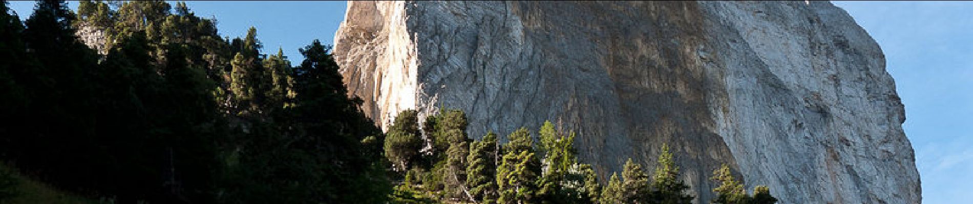
Le Rocher du Pansaret est connu pour la vue saisissante qu'il offre sur le formidable escarpement Nord-Est du Mont Aiguille. Seulement depuis la route forestière de Font-Rousse – hameau des Pellas – l'accès raide au belvédère par le Bois de la Draye ne permet pas d'imaginer un sommet herbeux à la vue imprenable. Alors sans plus d'information, la large clairière herbeuse du versant Nord-Ouest de la crête est attirante. Traverser l'espace libre permet d'atteindre la crête du Rocher du Pansaret par une ravine pierreuse dans un raide couloir terreux et herbeux au pied d'un ressaut rocheux, 1660m. La formidable falaise du Mont Aiguille domine toute la fin du parcours. Description complète sur sentier-nature.com : Le Rocher de Pansaret (tentative) Avertissement [Franchissement 2/5 ; Exposition 2/5 ; Orientation 1/5 ; Pénibilité 2/5].Certains passages de cet itinéraire de montagne sont escarpés et/ou très exposés, il est déconseillé aux enfants non accompagnés et aux personnes sujettes au vertige. Certains passages de cet itinéraire de montagne sont escarpés et/ou exposés, il est déconseillé aux enfants non accompagnés et aux personnes sujettes au vertige. Pour votre sécurité, nous vous invitons à respecter les règles suivantes : être bien chaussé, ne pas s'engager par mauvais temps, ne pas s'écarter de l'itinéraire ni des sentiers.
Positioning
Comments
Trails nearby
![Trail Walking Saint-Michel-les-Portes - Grand Ceymont par la face Sud - Photo](https://media.geolcdn.com/t/375/260/d58be866-4722-407f-9e9c-e7428ea96660.jpg&format=jpg&maxdim=2)
![Walking Walking](https://static1.geolcdn.com/sitytour/trail-icons/101.png)
Walking
![](/images/other/stat-length.png)
![](https://static1.geolcdn.com/siteimages/upload/files/16400158638029165_repeat_loop_refresh_sync_direction_icon.png)
![Trail Walking Gresse-en-Vercors - Quinquambaye - crête du Brisou - Photo](https://media.geolcdn.com/t/375/260/686aed71-19ef-4a34-8333-a2b65dd9c4d5.jpg&format=jpg&maxdim=2)
![Walking Walking](https://static1.geolcdn.com/sitytour/trail-icons/101.png)
Walking
![](/images/other/stat-length.png)
![](https://static1.geolcdn.com/siteimages/upload/files/16400158638029165_repeat_loop_refresh_sync_direction_icon.png)
![Trail Walking Gresse-en-Vercors - Traversée du Rocher du Baconnet - Photo](https://media.geolcdn.com/t/375/260/ext.jpg?maxdim=2&url=https%3A%2F%2Fservices.sitytrail.com%2FGeolivesWS%2FDownloadMedia.ashx%3FTrailID%3D105962%26Media%3D10040_1.jpg)
![Walking Walking](https://static1.geolcdn.com/sitytour/trail-icons/101.png)
Walking
![](/images/other/stat-length.png)
![](https://static1.geolcdn.com/siteimages/upload/files/16400158638029165_repeat_loop_refresh_sync_direction_icon.png)
![Trail Walking Gresse-en-Vercors - traversée Sud nord du Grand Veymont - Photo](https://media.geolcdn.com/t/375/260/3004a1b5-ea0f-48e3-8863-72e77652ad4d.jpg&format=jpg&maxdim=2)
![Walking Walking](https://static1.geolcdn.com/sitytour/trail-icons/101.png)
Walking
![](/images/other/stat-length.png)
![](https://static1.geolcdn.com/siteimages/upload/files/16400158638029165_repeat_loop_refresh_sync_direction_icon.png)
![Trail Walking Chichilianne - 14923554-Tour du Mont Aiguille - Photo](https://media.geolcdn.com/t/375/260/ext.jpg?maxdim=2&url=https%3A%2F%2Fstatic1.geolcdn.com%2Fsiteimages%2Fupload%2Ffiles%2F1553511878bg_sport_marche.png)
![Walking Walking](https://static1.geolcdn.com/sitytour/trail-icons/101.png)
Walking
![](/images/other/stat-length.png)
![](https://static1.geolcdn.com/siteimages/upload/files/16400158638029165_repeat_loop_refresh_sync_direction_icon.png)
![Trail Walking Saint-Michel-les-Portes - Tour du Mont Aiguille - Photo](https://media.geolcdn.com/t/375/260/13641da4-549e-49b9-8e23-d4a17f7e4345.jpg&format=jpg&maxdim=2)
![Walking Walking](https://static1.geolcdn.com/sitytour/trail-icons/101.png)
Walking
![](/images/other/stat-length.png)
![](https://static1.geolcdn.com/siteimages/upload/files/16400158638029165_repeat_loop_refresh_sync_direction_icon.png)
![Trail Walking Gresse-en-Vercors - le grand veymont depuis gresse en vercors et par le pas de la ville - Photo](https://media.geolcdn.com/t/375/260/ext.jpg?maxdim=2&url=https%3A%2F%2Fstatic1.geolcdn.com%2Fsiteimages%2Fupload%2Ffiles%2F1553511878bg_sport_marche.png)
![Walking Walking](https://static1.geolcdn.com/sitytour/trail-icons/101.png)
Walking
![](/images/other/stat-length.png)
![](https://static1.geolcdn.com/siteimages/upload/files/16400158638029165_repeat_loop_refresh_sync_direction_icon.png)
![Trail Walking Saint-Michel-les-Portes - Pas de Bachassons et de la Selle - Photo](https://media.geolcdn.com/t/375/260/10e42988-cabf-4bc0-8c6b-1118178d695b.jpg&format=jpg&maxdim=2)
![Walking Walking](https://static1.geolcdn.com/sitytour/trail-icons/101.png)
Walking
![](/images/other/stat-length.png)
![](https://static1.geolcdn.com/siteimages/upload/files/16400158638029165_repeat_loop_refresh_sync_direction_icon.png)
![Trail Walking Gresse-en-Vercors - Pas de Serpaton et crêtes, de Gresse en Vercors - Photo](https://media.geolcdn.com/t/375/260/184f68f2-62ff-4093-8bd0-69314b118936.jpg&format=jpg&maxdim=2)
![Walking Walking](https://static1.geolcdn.com/sitytour/trail-icons/101.png)
Walking
![](/images/other/stat-length.png)
![](https://static1.geolcdn.com/siteimages/upload/files/16400158638029165_repeat_loop_refresh_sync_direction_icon.png)