![](/images/other/stat-length.png)
![Trail Mountain bike Plestin-les-Grèves - Circuit des chapelles, coté terre - Plestin-les-Grèves - Photo](https://media.geolcdn.com/t/1900/400/ext.pjpeg?maxdim=2&url=https%3A%2F%2Fservices.sitytrail.com%2FGeolivesWS%2FDownloadMedia.ashx%3FTrailID%3D105558%26Media%3D9320_2.jpg)
Circuit des chapelles, coté terre - Plestin-les-Grèves
tracegps
User
![Length](/images/other/stat-length.png)
Length
17.1 km
![Max alt](https://static1.geolcdn.com/siteimages/upload/files/1508320355ic_sort_altitude_max_24dp.png)
Max alt
124 m
![Uphill gradient](https://static1.geolcdn.com/siteimages/upload/files/1508320355ic_sort_den_pos_24dp.png)
Uphill gradient
228 m
![Km-Effort](/images/other/stat-length.png)
Km-Effort
20 km
![Min alt](https://static1.geolcdn.com/siteimages/upload/files/1508320355ic_sort_altitude_min_24dp.png)
Min alt
6 m
![Downhill gradient](https://static1.geolcdn.com/siteimages/upload/files/1508320355ic_sort_den_neg_24dp.png)
Downhill gradient
229 m
![Boucle](https://static1.geolcdn.com/siteimages/upload/files/16400158638029165_repeat_loop_refresh_sync_direction_icon.png)
Boucle
Yes
Creation date :
2014-12-10 00:00:00.0
Updated on :
2014-12-10 00:00:00.0
![Mountain bike](https://static1.geolcdn.com/sitytour/trail-icons/202.png)
2h00
Difficulty : Medium
![Scan this QR Code to open this trail in the SityTrail application](https://capi.geolives.com/qq0zvz2zws4bq2lad0pu/sitytour/trails/105558/qr.png?size=200)
FREE GPS app for hiking
About
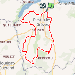
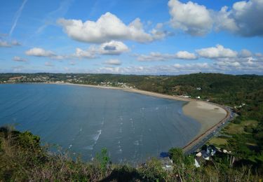
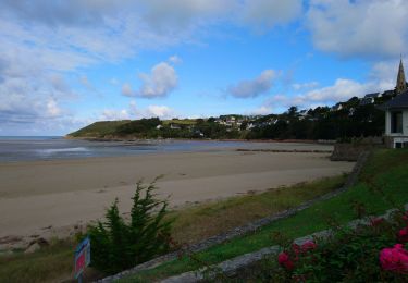
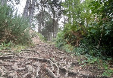
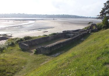
Trail Mountain bike of 17.1 km to be discovered at Brittany, Côtes-d'Armor, Plestin-les-Grèves. This trail is proposed by tracegps.
Description
Circuit VTC proposé par Office de Tourisme de la Lieue de Grève . Départ du parking des magasins en direction de Coat Carric à Plestin-les-Grèves. Téléchargez la fiche du circuit.
Positioning
Country:
France
Region :
Brittany
Department/Province :
Côtes-d'Armor
Municipality :
Plestin-les-Grèves
Location:
Unknown
Start:(Dec)
Start:(UTM)
453867 ; 5390131 (30U) N.
Comments
Trails nearby
![Trail Walking Saint-Michel-en-Grève - Saint-Michel-en-Grève - GR34 le Grand Rocher - 12km 300m 4h05 - 2023 09 13 - Photo](https://media.geolcdn.com/t/375/260/40f0733a-b9f3-4dc8-a8b9-5b02748d9947.jpg&format=jpg&maxdim=2)
![Walking Walking](https://static1.geolcdn.com/sitytour/trail-icons/101.png)
Saint-Michel-en-Grève - GR34 le Grand Rocher - 12km 300m 4h05 - 2023 09 13
Walking
Difficult
Saint-Michel-en-Grève,
Brittany,
Côtes-d'Armor,
France
![](/images/other/stat-length.png)
12.1 km | 16 km-effort
4h 5min
![](https://static1.geolcdn.com/siteimages/upload/files/16400158638029165_repeat_loop_refresh_sync_direction_icon.png)
Yes
![Trail Walking Saint-Michel-en-Grève - Saint-Michel-en-Grève - GR34 Beg ar Forn Église - 7.7km 200m 2h15 (50mn) - 2023 09 13 - Photo](https://media.geolcdn.com/t/375/260/bd360931-dba5-41e4-8b43-2e110bb983db.jpg&format=jpg&maxdim=2)
![Walking Walking](https://static1.geolcdn.com/sitytour/trail-icons/101.png)
Saint-Michel-en-Grève - GR34 Beg ar Forn Église - 7.7km 200m 2h15 (50mn) - 20...
Walking
Medium
Saint-Michel-en-Grève,
Brittany,
Côtes-d'Armor,
France
![](/images/other/stat-length.png)
7.7 km | 10.4 km-effort
2h 15min
![](https://static1.geolcdn.com/siteimages/upload/files/16400158638029165_repeat_loop_refresh_sync_direction_icon.png)
Yes
![Trail Walking Saint-Michel-en-Grève - Bretagne nord J6pm : St Michel en Grève - Locquémau - Photo](https://media.geolcdn.com/t/375/260/5addfac7-c616-4bd4-a226-cf31118124b4.jpg&format=jpg&maxdim=2)
![Walking Walking](https://static1.geolcdn.com/sitytour/trail-icons/101.png)
Bretagne nord J6pm : St Michel en Grève - Locquémau
Walking
Very easy
Saint-Michel-en-Grève,
Brittany,
Côtes-d'Armor,
France
![](/images/other/stat-length.png)
8.2 km | 10.3 km-effort
2h 19min
![](https://static1.geolcdn.com/siteimages/upload/files/16400158638029165_repeat_loop_refresh_sync_direction_icon.png)
No
![Trail sport Locquirec - Locquirec aire camping car - Photo](https://media.geolcdn.com/t/375/260/754c0ff3-9b6b-4a66-9c43-1eb5799626ce.jpg&format=jpg&maxdim=2)
Locquirec aire camping car
sport
Very easy
Locquirec,
Brittany,
Finistère,
France
![](/images/other/stat-length.png)
10.5 km | 12.7 km-effort
Unknown
![](https://static1.geolcdn.com/siteimages/upload/files/16400158638029165_repeat_loop_refresh_sync_direction_icon.png)
Yes
![Trail Walking Plestin-les-Grèves - Locquirec 07-06-19 - Photo](https://media.geolcdn.com/t/375/260/233fc2cd-7a83-4647-afd9-9c2802a6d42c.jpg&format=jpg&maxdim=2)
![Walking Walking](https://static1.geolcdn.com/sitytour/trail-icons/101.png)
Locquirec 07-06-19
Walking
Medium
Plestin-les-Grèves,
Brittany,
Côtes-d'Armor,
France
![](/images/other/stat-length.png)
12.4 km | 14.7 km-effort
3h 38min
![](https://static1.geolcdn.com/siteimages/upload/files/16400158638029165_repeat_loop_refresh_sync_direction_icon.png)
No
![Trail Walking Locquirec - lokirec - Photo](https://media.geolcdn.com/t/375/260/ext.jpg?maxdim=2&url=https%3A%2F%2Fservices.sitytrail.com%2FGeolivesWS%2FDownloadMedia.ashx%3FTrailID%3D1007316%26Media%3Dfix__20180720145712.jpg)
![Walking Walking](https://static1.geolcdn.com/sitytour/trail-icons/101.png)
lokirec
Walking
Very easy
Locquirec,
Brittany,
Finistère,
France
![](/images/other/stat-length.png)
4.6 km | 5.7 km-effort
1h 12min
![](https://static1.geolcdn.com/siteimages/upload/files/16400158638029165_repeat_loop_refresh_sync_direction_icon.png)
Yes
![Trail Walking Plestin-les-Grèves - Plestin les grèves - Photo](https://media.geolcdn.com/t/375/260/ext.jpg?maxdim=2&url=https%3A%2F%2Fservices.sitytrail.com%2FGeolivesWS%2FDownloadMedia.ashx%3FTrailID%3D976026%26Media%3Dfix__20180521113044.jpg)
![Walking Walking](https://static1.geolcdn.com/sitytour/trail-icons/101.png)
Plestin les grèves
Walking
Medium
Plestin-les-Grèves,
Brittany,
Côtes-d'Armor,
France
![](/images/other/stat-length.png)
11.9 km | 14.7 km-effort
3h 10min
![](https://static1.geolcdn.com/siteimages/upload/files/16400158638029165_repeat_loop_refresh_sync_direction_icon.png)
Yes
![Trail Walking Plestin-les-Grèves - Embouchure du Douron - Plestin Les Grèves - Photo](https://media.geolcdn.com/t/375/260/ext.jpg?maxdim=2&url=https%3A%2F%2Fservices.sitytrail.com%2FGeolivesWS%2FDownloadMedia.ashx%3FTrailID%3D316909%26Media%3D16007_3.jpg)
![Walking Walking](https://static1.geolcdn.com/sitytour/trail-icons/101.png)
Embouchure du Douron - Plestin Les Grèves
Walking
Medium
Plestin-les-Grèves,
Brittany,
Côtes-d'Armor,
France
![](/images/other/stat-length.png)
10.7 km | 12.9 km-effort
3h 0min
![](https://static1.geolcdn.com/siteimages/upload/files/16400158638029165_repeat_loop_refresh_sync_direction_icon.png)
Yes
![Trail Walking Plestin-les-Grèves - De Plestin Les Grèves à Saint Efflam - Photo](https://media.geolcdn.com/t/375/260/ext.jpg?maxdim=2&url=https%3A%2F%2Fservices.sitytrail.com%2FGeolivesWS%2FDownloadMedia.ashx%3FTrailID%3D215055%26Media%3D15624_6.jpg)
![Walking Walking](https://static1.geolcdn.com/sitytour/trail-icons/101.png)
De Plestin Les Grèves à Saint Efflam
Walking
Medium
(1)
Plestin-les-Grèves,
Brittany,
Côtes-d'Armor,
France
![](/images/other/stat-length.png)
10.7 km | 13.4 km-effort
4h 0min
![](https://static1.geolcdn.com/siteimages/upload/files/16400158638029165_repeat_loop_refresh_sync_direction_icon.png)
Yes
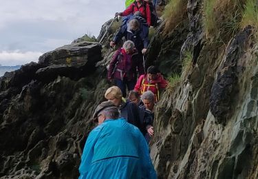
2 ou 3 passage dans les propriétés privées au il faut rebrousser chemin mais sinon très bien