![](/images/other/stat-length.png)
![Trail Mountain bike Bergholtz - Espace VTT - FFC Région de Guebwiller - n°19 - Circuit du Val de Pâtre - Photo](https://media.geolcdn.com/t/1900/400/ext.pjpeg?maxdim=2&url=https%3A%2F%2Fservices.sitytrail.com%2FGeolivesWS%2FDownloadMedia.ashx%3FTrailID%3D105541%26Media%3D9307_1.jpg)
Espace VTT - FFC Région de Guebwiller - n°19 - Circuit du Val de Pâtre
tracegps
User
![Length](/images/other/stat-length.png)
![Max alt](https://static1.geolcdn.com/siteimages/upload/files/1508320355ic_sort_altitude_max_24dp.png)
![Uphill gradient](https://static1.geolcdn.com/siteimages/upload/files/1508320355ic_sort_den_pos_24dp.png)
![Km-Effort](/images/other/stat-length.png)
![Min alt](https://static1.geolcdn.com/siteimages/upload/files/1508320355ic_sort_altitude_min_24dp.png)
![Downhill gradient](https://static1.geolcdn.com/siteimages/upload/files/1508320355ic_sort_den_neg_24dp.png)
![Boucle](https://static1.geolcdn.com/siteimages/upload/files/16400158638029165_repeat_loop_refresh_sync_direction_icon.png)
![Mountain bike](https://static1.geolcdn.com/sitytour/trail-icons/202.png)
2h00
Difficulty : Difficult
![Scan this QR Code to open this trail in the SityTrail application](https://capi.geolives.com/qq0zvz2zws4bq2lad0pu/sitytour/trails/105541/qr.png?size=200)
FREE GPS app for hiking
About
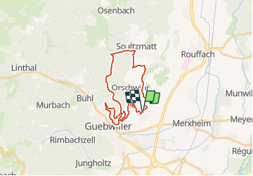
Trail Mountain bike of 24 km to be discovered at Grand Est, Haut-Rhin, Bergholtz. This trail is proposed by tracegps.
Description
Espace VTT - FFC Région de Guebwiller - n°19 - Circuit du Val de Pâtre Circuit officiel labellisé par la Fédération Française de Cyclisme. Magnifique circuit de 24 kilomètres sillonnant vignes et forêts avec de très beaux points de vue. Le val de Pâtre, dans un écrin de verdure, vous permettra de découvrir sa très belle chapelle. A proximité se situe le cimetière militaire roumain de la Gauchmatt. Le menhir du Langenstein, sur le chemin de retour, vous permettra de vous ressourcer. La chapelle du Val de Pâtre est dédiée à la Vierge depuis le XIIIème siècle et est un haut lieu du scoutisme. Le cimetière militaire de la Gauchmatt est l’unique cimetière roumain dans lequel reposent 687 soldats roumains faits prisonniers par les allemands durant la guerre de 1914-18. Déportés en Alsace pour y effectuer des travaux militaires, ils n’ont pu résister aux traitements infligés et sont morts de froid, de faim et de misère. L’entretien de ce cimetière est assuré par le « Souvenir Français ». Topo guide VTT en vente à l’Office du Tourisme de Guebwiller-Soultz et les Pays du Florival - Antenne de Guebwiller - 71 Rue de la République - 68500 – Guebwiller Tel. : 03 89 76 10 63 - Fax :03 89 76 52 72 Crédit photos ; ©Pays d’Art et d’Histoire de la Région de Guebwiller
Positioning
Comments
Trails nearby
![Trail Walking Westhalten - 2021 03 04 Westhalten - Photo](https://media.geolcdn.com/t/375/260/227de508-d68e-430e-b1c3-67de94c52b45.jpg&format=jpg&maxdim=2)
![Walking Walking](https://static1.geolcdn.com/sitytour/trail-icons/101.png)
Walking
![](/images/other/stat-length.png)
![](https://static1.geolcdn.com/siteimages/upload/files/16400158638029165_repeat_loop_refresh_sync_direction_icon.png)
![Trail Walking Rouffach - SityTrail - Rouffach vers Schauenberg variante - Photo](https://media.geolcdn.com/t/375/260/ext.jpg?maxdim=2&url=https%3A%2F%2Fstatic1.geolcdn.com%2Fsiteimages%2Fupload%2Ffiles%2F1553511878bg_sport_marche.png)
![Walking Walking](https://static1.geolcdn.com/sitytour/trail-icons/101.png)
Walking
![](/images/other/stat-length.png)
![](https://static1.geolcdn.com/siteimages/upload/files/16400158638029165_repeat_loop_refresh_sync_direction_icon.png)
![Trail Mountain bike Guebwiller - P4 Circuits du Florival 2021 - Photo](https://media.geolcdn.com/t/375/260/ext.jpg?maxdim=2&url=https%3A%2F%2Fstatic1.geolcdn.com%2Fsiteimages%2Fupload%2Ffiles%2F1524743154velo.jpg)
![Mountain bike Mountain bike](https://static1.geolcdn.com/sitytour/trail-icons/202.png)
Mountain bike
![](/images/other/stat-length.png)
![](https://static1.geolcdn.com/siteimages/upload/files/16400158638029165_repeat_loop_refresh_sync_direction_icon.png)
![Trail Mountain bike Westhalten - Westhalten - Le tour de la vallée Noble - Photo](https://media.geolcdn.com/t/375/260/ext.jpg?maxdim=2&url=https%3A%2F%2Fstatic1.geolcdn.com%2Fsiteimages%2Fupload%2Ffiles%2F1524743154velo.jpg)
![Mountain bike Mountain bike](https://static1.geolcdn.com/sitytour/trail-icons/202.png)
Mountain bike
![](/images/other/stat-length.png)
![](https://static1.geolcdn.com/siteimages/upload/files/16400158638029165_repeat_loop_refresh_sync_direction_icon.png)
![Trail Walking Buhl - AMAELLES - Rando 06/01/2025 - Bulh - Photo](https://media.geolcdn.com/t/375/260/7d3c9dff-b15b-4c79-abbd-c40015be5ccd.jpg&format=jpg&maxdim=2)
![Walking Walking](https://static1.geolcdn.com/sitytour/trail-icons/101.png)
Walking
![](/images/other/stat-length.png)
![](https://static1.geolcdn.com/siteimages/upload/files/16400158638029165_repeat_loop_refresh_sync_direction_icon.png)
![Trail Walking Westhalten - WESTHALTEN ZINKOEPHLE - Photo](https://media.geolcdn.com/t/375/260/bb43cbf9-190d-4da9-9235-1bfdec11bc91.jpg&format=jpg&maxdim=2)
![Walking Walking](https://static1.geolcdn.com/sitytour/trail-icons/101.png)
Walking
![](/images/other/stat-length.png)
![](https://static1.geolcdn.com/siteimages/upload/files/16400158638029165_repeat_loop_refresh_sync_direction_icon.png)
![Trail Walking Jungholtz - Rando Retrouvailles...01/03/2024.par Jean Marc - Photo](https://media.geolcdn.com/t/375/260/a9ee6325-7504-4fd2-a0fe-1e1c5b8164cc.jpg&format=jpg&maxdim=2)
![Walking Walking](https://static1.geolcdn.com/sitytour/trail-icons/101.png)
Walking
![](/images/other/stat-length.png)
![](https://static1.geolcdn.com/siteimages/upload/files/16400158638029165_repeat_loop_refresh_sync_direction_icon.png)
![Trail Walking Westhalten - Westhalten - Rouffach - Photo](https://media.geolcdn.com/t/375/260/573d5f52-f23d-4aea-a093-7c17bce8a144.jpg&format=jpg&maxdim=2)
![Walking Walking](https://static1.geolcdn.com/sitytour/trail-icons/101.png)
Walking
![](/images/other/stat-length.png)
![](https://static1.geolcdn.com/siteimages/upload/files/16400158638029165_repeat_loop_refresh_sync_direction_icon.png)
![Trail Walking Buhl - TL 11/23 avec un petit tour dans le vignoble avec départ du parking Côte de l'Appenthal et repas à la Taverne du Vigneron - Photo](https://media.geolcdn.com/t/375/260/ext.jpg?maxdim=2&url=https%3A%2F%2Fstatic1.geolcdn.com%2Fsiteimages%2Fupload%2Ffiles%2F1553511878bg_sport_marche.png)
![Walking Walking](https://static1.geolcdn.com/sitytour/trail-icons/101.png)
Walking
![](/images/other/stat-length.png)
![](https://static1.geolcdn.com/siteimages/upload/files/16400158638029165_repeat_loop_refresh_sync_direction_icon.png)